Empire State Building
Thursday, 7th April 2005 by James Turnbull
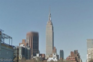
There's loads of cool things to find in Manhattan, but this shot of the Empire State Building is probably the best. The photo is at quite an angle so you can see a lot of the building. Also, over to the West, you can easily spot Madison Square Garden; it's the big circle.


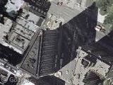
When the photograph is clear down to the highest resolution/zoom, you’re looking at an aerial photograph. The very grainy areas are taken from satellite. Satellites can only achieve a resolution of 30 feet per pixel, I believe. The aerial photographs you’re viewing in New York City and the entire state of New Jersey are likely 1 foot size.
Oooo, makes me feel like I’m standing on my head. Is this what it feels like to live in Australia? 🙂
Actually, some of the new government sattelites can determine an object the size of a softball.
Actually, some of the new government sattelites can determine an object the size of a softball.
I’d like to know where you heard that.
GPS devices can determine where you are within a few centimeters because of the coded signal you receive. But if you are trying to observe something from space using only the radiated energy, you won’t be able to get a clear lock on the object. Even satellites that beam radiation to the surface and record the reflected signal are subject to the interference in the Earth’s atmosphere that make what you speak of impossible.
Unless I misinterpretted what you meant, or if something new came out within the last year, I highly doubt what you claim as actually being feasible.
the IKONOS, Quickbird & OrbView-3 satellites can get a spatial resolution of 1m in the panchromatic band, and 4m in the multispectral bands. These sensors are commercial, owned by private companies, and sell imagery..
The gov’t classified stuff can resoove the stitching on a baseball..THE STITCHING…yes, that’s intense…
…oh, but yes, the hi-res imagery on this site is digital aerial imagery, NOT satellite imagery. The imagery for New Jersey is 2ft. resolution taken in spring 2002. Google doesnt allow you to zoom in far enough to realize the full resolution capabilities of the hi-res stuff..
pastanous, how do you know it’s 2002, besides comparing whats-built-whats-not on the images? Is it listed anywhere on Google’s site? I’m just curious if they got them from the same source as the false color images on the State’s site.
Hello you ignorants (no offense!), FYI:
(Most of these facts should be easily researchable on the Internet in no more than 5 minutes.)
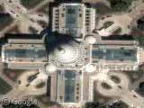
Quite nice. I can easily locate my abode proximate to the hidious Port Authority on 8th Ave and 40 – 42nd St.
Heyy!!! I want to see more maps, like.. where do i go in google?
Kab, they only have satelite imagry for the usa right now
dis iz confuzing……………………………………………………………………………..
I LIVEON 111 BOKA NOCKA ST