Staples Centre, LA
Friday, 8th April 2005 by James Turnbull
Following on from the 'Dave' post yesterday I've created a new category for legible text called 'Large Type'.
The first of which is the Staples Centre, LA (Props: jbum). I'd like to think they put the text there on the off chance that James Bond was passing by in a helicopter and really needed a paperclip to defuse the bomb that was onboard. He'd look out the window, spot the Staples Centre, the world would be safe and he'd be home in time for Tea.
It's more likely that the centre is in a popular flight-path - but you never know 😉
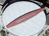
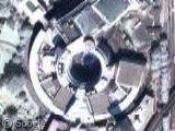
One probable reason the text is there is for blimp-based shots of the venue that show appear during sports broadcsts.
I don’t think it’s on any flight path, LAX is 5 miles to the south and the planes come in from almost due east. The blimp theory makes a lot more sense.
I would have to agree with the blimp theory… big games draw blimps, even if the games are inside… i’m sure when Kobe and Shaq were playing nice and the Lakers didn’t suck, blimps were commonplace (think NBA Finals) and the advertising was well worth it.
Actually, the Staples Center is not only in the flight path to LAX, but it is at almost the exact point that planes make the turn back towards the coast. It’s almost like the planes tilt to get a better look at Staples. Flight from the Bay Area all make the turn, as well as other flights originating from further north. Generally, the flight path follows the coast line, heads inland a bit, makes a left turn at UCLA, flies out to downtown, makes the U-turn and comes straight into one of the four runways.
The FAA approach is actually labeled “Stadium Visual RWY 24L/R”. The flight path is ENE from the Santa Monica VOR, then a right turn at the coliseum to align with the Santa Monica Freeway, then another right turn onto final approach.
FAA approach plate for stadium visual: http://204.108.4.16/d-tpp/0503/00237STADIUM_VIS24LR.PDF
I guess I was thinking more of the immediate approach. Throw in that most of my flights are to points east (we usually make a left turn leaving LAX), and I guess that’s why I didn’t think of Staples Center as being in the flight path. It looks like the planes are about 5000-feet high at that point, is the writing legible at that altitude?
Wow Josh, that is a really cool link, thanks!
Jake- You can definitely see the arena from the air and read the writing. At night there is a disitct purple glow from the lights at the staples center too.