Elmendorf Air Force Base
Friday, 22nd April 2005 by James Turnbull
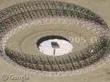
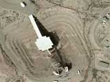
This "Elephant Cage" in Elmendorf Air Force Base, Alaska is part of the DOD World Wide High Frequency Direction Finding System. More information on the system is availble from the Federation of American Scientists.
Thanks: Gabe
Just staring at the thing is giving me headache.
Amazing image.
How bizarre. I can hardly get my bearings looking at that. Great one!
I cannot get my mind around the perspective in this photo. It’s like those optical illusion drawings of three-tined forks.
I guess it’s because of the high latitude, but you’re looking at it such that if you continued toward the ground, you would be upside down.
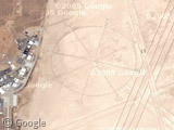
A similar structure actually also exists in San Diego View Placemark
Great image of a facinating facility. High latitude shots like this are a good example of why an appropriate projection can make all the difference. See wikipedia entry:
http://en.wikipedia.org/wiki/Map_projections
Looks like they’ve stopped squishing the maps now that they’ve got more non-US detail..
My OCD kicked in and I found more of these:
View Placemark
View Placemark
View Placemark,.159130&t=k&hl=en
View Placemark
View Placemark
The similar structure in San Diego is part of a Navy Training Area where the Navy trains SEALs. The grid structure north of the antenna is a MOUT (missions on urban terrain) city fighting training area.
I liked the different view. I was stationed there when it was first put to use. I was just in the area in June 06 and saw it was still there. Thans for the memories.
I found another one at Karamusel, Turkey
The previous link is wrong.
The correct link is Karamusel, Turkey
The FLR9 was reffered to as the elephant cage @ clark afb in the phillipines. We referred to it as the Moose Cage at Elmendorf