Liberty Island
Thursday, 7th April 2005 by James Turnbull
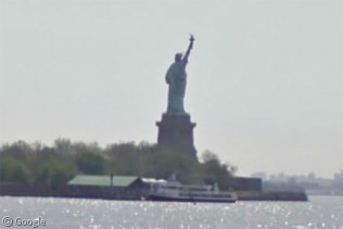
The Statue of Liberty and Liberty Island. You can also see the Staten Island ferry going past in the bottom right.

Not sponsored by or affiliated with Google
Thursday, 7th April 2005 by James Turnbull
The Statue of Liberty and Liberty Island. You can also see the Staten Island ferry going past in the bottom right.

If you scroll to the north you can see Ellis Island, the “Island of Tears”, where 12 million immigrants entered the US from 1892 to 1954. The island is now a fascinating immigration museum.
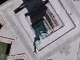
The original natural island was expanded over the years which is why it now has a man-made shape. ” The south side was a hospital and communicable disease ward. The north side was the main hall where immigrant registration took place. The “triangle” on the north side is the current site of the immigrant wall of honor. You can get your immigrant ancestors’ names inscribed there (and read a whole lot about it) at http://www.ellisisland.org. In the center of the island is a ferry port where visitors enter. Currently there is a boat just arriving. Finally, at the “rear” of the island is a bridge to the mainland (Liberty State Park in Jersey City, NJ). The bridge was built in the 1980’s to support the conversion to a museum and is currently used by workers.
Oops. I forgot to mention. Both Liberty Island and Ellis Island are closer to New Jersey than New York, but they are both part of New York except for the south end of Ellis Island which is part of New Jersey. It’s complicated.
That’s not the Staten Island Ferry – it’s a tourist sightseeing boat. The Staten Island Ferry boats are much larger than that:
View Placemark
Looks to me that there is two boats under water at the shouthern side of liberty island. Does anyone know anything about this or am I mistaken?