Rowing On The Charles River
Thursday, 12th May 2005 by Alex Turnbull
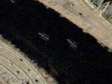
Apparently one of the most popular (and picturesque) sports in Boston/Cambridge is rowing on the Charles River. This view near Harvard University captures several 8-person racing shells in mid-stroke. Very cool.
Cashman Andrus says:
You can clearly see the paddles of these boats (8 rowers plus a coxswain). That's the Harvard boathouse in the lower right corner (The one with the red roof).
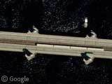
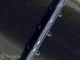
Further down-river you can see one of Boston's "Red Line" subway trains crossing the Longfellow Bridge (aka "the salt and pepper bridge" because of the shape of the towers). The train shown in this shot is travelling from Cambridge to Boston. David says that:
A train crossing this bridge is used in virtually every 'establishing shot' for movies and tv shows that take place in Boston.
And that's good enough for me to put this post in the Movie Locations category 😉
Many thanks to P-Dunny, Cashman Andrus and David
About the author
Alex has decided that his title will be Senior Vice President of Stuff.

The docks immediately south and east of the subway car belong to Community Boating, where kids can sail all summer for just $1. (The boats visible at the docks are mostly mercuries. Moored beyond the docks are larger boats like typhoons.)
And just south of there is the Hatch Shell, the site of many open-air concerts (including those of the Boston Pops).
The Schuykill River upstream of Philadelphia’s famous Boathouse Row is riddled with crew teams out on the water.
For some reason those row boats made me think of caterpillars…
Down the river a bit is the BU Bridge, so named because it takes you to MIT. Supposedly, this is a unique point where, due to flight lanes, it is possible to have an airplane above a car above a train above a boat.
View Placemark
That is nuts when you think about it. You can almost see individual people. It’s part of Googles master plan.
Would you believe Rowing on the Passaic River downtown Newark NJ. It’s either Belleville. Kearny or Nutley High Schools who normally row North of the the Belleville Bridge which was closed for renovation, so date the photo aroun 2003.
View Placemark
I can see the boats with google maps, but when I look in google earth they are gone …
this is proof that google earth is actually government-run and they are really spying on all of us with out-dated sattelites.