Rio-Niterói Bridge
Wednesday, 7th September 2005 by Alex Turnbull
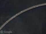
This is the Rio-Niterói Bridge, which connects Rio de Janeiro with Niterói in Brazil. Built between 1969 and 1974, this gargantuan structure is over 13 kilometres long (8.25 miles) and is a record holder for the size of it's central space - the highest in the world at 72 metres (Wikipedia page).

At one point the bridge touches down on an island, and there's also a great curve in the bridge as it passes into Rio.
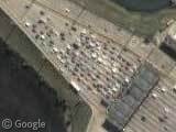
The bridge carries approximately 230,000 vehicles each day, and you can see the large queue of cars waiting to pay their toll in Niterói (and also a very cool spaghetti junction awaiting them on the other side).
Thanks to Fabiano Limeira, Thiago M. F., Halio Freitas, Wilson Baptista Junior, Abrico Panaro and Rob Marshall.

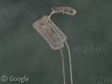
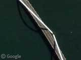
The island under the bridge appears to be some sort of naval facility.
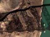
The first island west of the toll booths has two oil rigs under construction. And a bit further southwest in the channel you can see another one being worked on or undertow.
At the other end of the bridge you can see a ship being built: View Placemark
The Google Earth links are not working with the latest version of Google Earth. Shows up empty.
tt, thanks for letting us know! olly’s fixed it now, so everything should be back in business again!
Any problems, please post here 🙂
If you zoom in on the bridge, you see (if you’re using Google Earth) left of the little island that a part of the photo is placed wrong. I just wanted to tell, because it looks very funny!
The island is where Brazilian’s Navy keeps something of its arsenal, it’s the Mocanguê island.
Aircraft carriers!
View Placemark