Sh*t Happens
Tuesday, 4th October 2005 by Alex Turnbull
Please note that some or all of the objects mentioned in this post are no longer visible on Google Earth or Google Maps.
Was this person really not able to think of anything more noteworthy to write in the sand than 'Sh*t Happens'? Mind you, it got posted here I suppose...
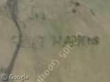
Thanks to Marilyn Largent
About the author
Alex has decided that his title will be Senior Vice President of Stuff.
I thought it was interesting that the maps didn’t show those as islands. I checked my 1981 wall map of Houston, and there is no indication of anything there past Morgan’s Point.
As that’s right next to the Houston Ship Channel, I suspect that’s a bunch of dredging output.
There’s lots of recrational boating on Galveston Bay, so it’s no doubt the timely work of drunken sailors.
I live in Houston, and I’m not entirely sure what this is. This is next to the Galveston/Kemah water line and ship channel (I actually submitted this boating line a few weeks ago for the blue tankers). My guess is someone got bored…
The map shows the upper part of this island, the part we’re concerned with may have been built up, or may be a sandbar… but how could someone write tha tin an underwater sandbar?
On an interesting note, there’s also what looks like a star over here… View Placemark
Ah, Houston, my Houston. =)
I CANT FIND THE THING THAT SAYS SHIT HAPPENS!!!! Im serous though i looked all over the island and i cant find it can some1 give me the latitude and longitude?
Myagooshki, this sight is not longer visible, as noted at the top of the post.