Giant Triangle
Friday, 24th March 2006 by James Turnbull
Here's a mystery for a Friday morning - why is there a giant equilateral triangle in the desert near the city of Surprise, Arizona? And why does the city have such a silly name?
It looks to me like it could be an old airfield but it could, of course, be aliens!
Thanks: Craig Simpson

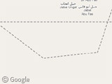
Mike – muhhamed already found what this was and posted a link on the first page of comments. Here it is again for you:
http://members.tripod.com/airfields_freeman/AZ/Airfields_AZ_Phoenix_NW.htm
Scroll to the bottom to see this location. It’s called Luke Auxiliary Army Airfield #4.
if you look under the long road at the bottom of the triangle in the middle and zoom in their is a little feild….wonder what that was used 4?
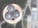
can someone explain the extrange circular shapes by the triangles?
Those are auto manufacturer testing facilities. Chrysler, Volvo, and a third are in the area. Nothing exciting.
Ahhh I would love to say its something more than what Michael has said, but alas I cannot….then again…we could be disinformers hahahaha no just kidding…