Australia Shrunk Shocker!
Friday, 3rd March 2006 by Alex Turnbull
It seems that some evil genius has invented a shrink-ray, and the first thing he shrunk was the whole of Australia! Well, it was too big anyway.
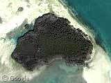
Thanks to a very tiny Adam Lewis.
About the author
Alex has decided that his title will be Senior Vice President of Stuff.
This is just too weird. What’s the story behind this?
Heres a link to the original post on GEC–very funny.
http://tinyurl.com/zz9r8
Topozone calls this island Riding Key. http://www.topozone.com/map.asp?lat=24.753018&lon=-81.549636&datum=NAD83&u=5
Not much info on it except as a minor boating landmark.
Here it is on mapquest: http://www.mapquest.com/maps/map.adp?address=&city=&state=FL&zipcode=&country=US&title=%3cb%3eFL%20US%3c%2fb%3e&cid=lfmaplink2&name=
What happened to the Cape York peninsula?
And what about the Australians????
are they inside as little “australiants”
i once got a beef that was formed like australia… it rocked! and btw: http://www.snopes.com/photos/natural/ozmud.asp also pretty weird… ^_^
Only thing missing is a “Map of Tassie”
For those of you who are not Aussie:
http://www.amazingaustralia.com.au/language.htm