Lindisfarne (Island week 3)
Wednesday, 3rd September 2008 by Alex Turnbull
It’s Island Week 3 here at GSS, which means we’ll mostly be posting about Islands. It'll probably last about a week.
Lindisfarne is a tidal island, off the north-east coast of England, which thanks to having been home to a monastery since the 7th century AD, is also known as Holy Island.
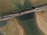
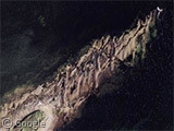
The causeway that connects Lindisfarne to the mainland is flooded twice a day by the tide (you can see the tidemark on this section of the road), so drivers must be careful about when they start to cross. Refuge places are provided for the cars should they become stranded by quickly rising water.
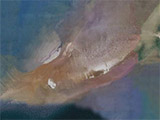
Before the advent of cars those wishing to reach the monastery would have had to cross the sands on foot at low tide. Known as Pilgrim's Way, we can see the markers that still define that path today, as well as small refuge boxes for those who choose a foolish time to attempt the walk.
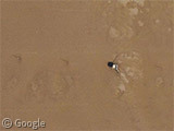
Here's the second refuge box on the Pilgrim's Way, but following the markers along there are no people to be seen, probably because a large section of the path is under water.
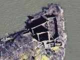
Where the Pilgrim's way finally meets land we find a nice modern-day maze of, er... something, and just south of here we finally come across the ancient ruins of the island's monastery.
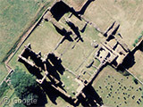
To the east of the monastery, we can also see the small Lindisfarne Castle and the old castle limekilns, which are in the care of the National Trust and open to visitors.
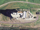
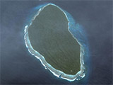
Elsewhere on the island there are monuments, some spectacular sections of coastline, lots of sand, and there's even a lake for all you recursion junkies.
There's more about the long history of Lindisfarne at Wikipedia, or have a look at this PDF of the island's sights.
See also the previously featured Mont Saint Michel tidal island.
Especially for Spamboy.
About the author
Alex has decided that his title will be Senior Vice President of Stuff.

Very impressive, I havent thought about this place in a long time. I was on a school trip at the age of 10 and burried my butties (sandwiches) in that same sand in 1984!!
“Fog on the Tyne is all mine all mine Fog on the Tyne is all mine”
I cant believe you got through a whole post about Lindisfarne without mentioning one of the greatest records ever made.
@cookie monster: lol! I couldn’t bear to link to it 😉
For those of you who are confused, this should clear matters up: Lindisfarne (band)
Dude, you totally made my night with this post — thanks for the great write-up of one of my favorite places.
OH~~How interesting ! I can not help to teavelling there . The bridge is so funny.
The maze you refer to is a ‘Maize Maze’, it’s been open a few years. The Island is one of my favourite places, especially if you stay in one of the few hotels over-night, when you have the place almost to yourself!
Whereabouts is Maize Maze?
I guess it should be pointed out that this “something” is the ruins of one of the very first christian churches of Britain. Iona (another island) and Lindisfarne is often considered as the two principal monasteries of early British christianity.