Chichen Itza
Wednesday, 8th October 2008 by Ian Brown
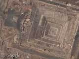
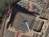
Chichen Itza (Wikipedia) is one of the largest and most significant Mayan sites in Mexico. El Castillo (the Castle) is a 30m high pyramid and temple that is the focal point of the site.

At the spring and autumn equinox, the rising and setting sun hits the corner of the pyramid to form a shadow resembling a serpent. Climbing such pyramids is not for the faint-hearted, and El Castillo has been closed to tourists since 2006 when somebody fell to their death.
Between approximately AD 600 and AD 1000 Chichen Itza dominated social, political and economic aspects of life in this area of the Mayan civilization. Its population is estimated to have been between 40,000 and 50,000.
Archaeologists continue to discover new structures buried in the forest. Significant locations currently visible (map) include the great ball court used for a game vaguely similar to volleyball and the cenotes or wells of sacrifice.


Imagery of other Mayan sites such as Tikal in Guatemala is not so impressive. Let us know if you find other Mayan sites with good resolution.
Thanks to Paul Wilson.
About the author
Ian Brown lives in Ottawa, Canada, and spends his spare time perusing maps to find new routes to ride on his orange bicycle.
I don’t think they closed the El Castillo pyramid because “somebody fell to their death” I believe that many of the structures in major Maya sites where closed after a big hurricane hit the Yucatan Peninsula some years ago. This natural disaster damaged the structures and in order to prevent more damage (caused by humans) the INAH (the mexican governmental entity that looks for all archeological sites in the country) prohibited the climbing to visitors.
Hi,
so if you’re looking for other mayan site with good resolution here are is another one: – Tulum According to many sourcesthis is the only Mayan Site wich is at seaside. The resolution is quite high.
Ciao, Simone
acheteme – My understanding is that protection of the ruins is often given as the official reason for closure because it presents a less negative image. The incident that I heard about is this one: http://www.signonsandiego.com/uniontrib/20060206/news_1m6black.html
Simone – thanks for the Tulum link. I was there a couple of years ago and found it a fascinating site. The beach below the site is wonderful!
Maddeningly the satelite images of Palenque are literally a couple of 100 yards short of mapping one the the best Mayan sites in the world.
View Placemark
Monte Alban near Oaxaca has a good level of detail although I don’t think that’s Mayan :
View Placemark
the first one needs its own or wat ever lol but serious people now fix it