The Morganza Spillway – Spring Flooding Special
Wednesday, 18th May 2011 by Ian Brown
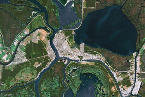
The Morganza Spillway is a flood management system on the Mississippi River in Louisiana, intended to protect the cities of Baton Rouge and New Orleans. It has recently been opened for only the second time since it was constructed 57 years ago.
Catastrophic flooding on the Mississippi in 1927 led to the long-term development of flood-control measures along the river. The Morganza Spillway was designed to divert water from the Mississippi into the Atchafalaya Basin in emergency situations, in order to prevent the inundation of the densely-populated cities to the south-east.
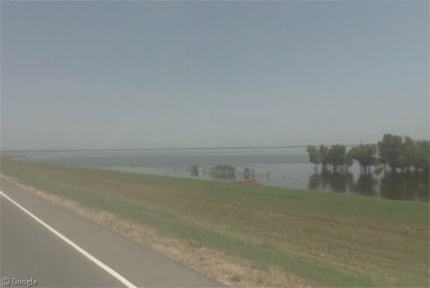
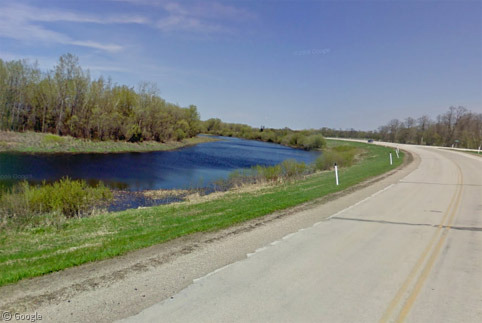
While the land on either side of the spillway is dry for much of the year, the Street View car gives us a clear view of what happens in the spring, with the entire area to the east of the highway under water.
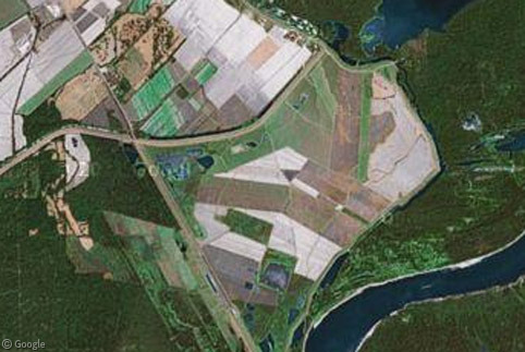
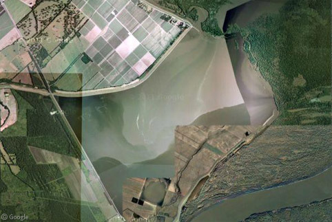
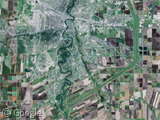
Google's standard satellite images give us a good idea of the extent of spring flooding, with different zoom levels showing cultivated farm land transformed to lake.
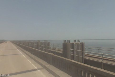
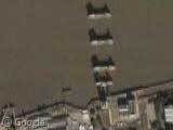
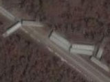
In addition to the two large sluice gates shown in the image at the top of this article, there are 125 smaller gates which allow precise management of water flow into the Spillway. In the only previous opening (in 1973), 42 of these gates were opened.
The process isn't without controversy, as diverting water from one river to another can threaten communities in different areas – such as Morgan City in the heart of the Atchafalaya Basin, which is already surrounded by water on all sides. Generally the justification given is that smaller communities can be devastated to spare millions of people in other areas.
As with many recent crises, Google has quickly responded with updated imagery of the affected area. You can read more on the Google Earth Blog, and use the KML file provided to view updated imagery in Google Earth. The Crisis Response Team has also provided a page with marked locations of flooding, emergency shelters and more.
Activating the Morganza location on that last link reveals a low-resolution image of the water gushing through the open gates.

The Morganza Spillway is used so rarely because of an additional flood-control system further upstream which can manage flood situations in all but the worst years. While it is a newer development (it was built in 1963) it is somewhat confusingly named the Old River Control Structure.
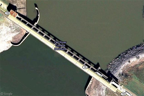
Without this constant control, the Mississippi would gradually shift course and potentially affect the entire region.
The Wikipedia page about the Morganza Spillway has been comprehensively updated over the past couple of days, including links to videos and images on many news sites and anticipated flood scenarios from the Army Corps of Engineers who are managing the operation.
There are also many videos on YouTube showing the gates being opened, including a few that show large numbers of fish leaping from the turbulent waters.
Meanwhile in Canada, Winnipeg is again threatened by record high waters. We visited the Red River Floodway a couple of years ago. The city's other river, the Assiniboine, is not protected in the same way so a dike has had to be cut to the west of the city.
Similar to the situation in Louisiana, this could potentially flood up to 150 homes and farms, while also saving many hundreds more downstream. The cut took place at the delightfully-named Hoop and Holler Bend.
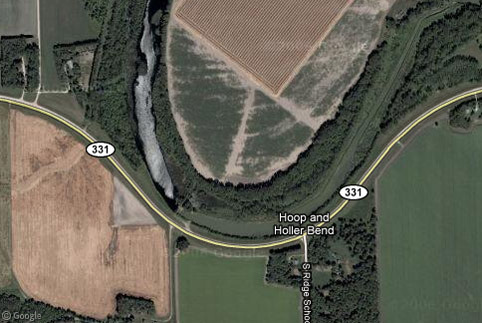
The river looks so placid in the Street View image of the location of the cut, yet the CBC's coverage gives you a sense of the dire situation that is unfolding.
Our thoughts are with everyone currently dealing with flood situations.
About the author
Ian Brown lives in Ottawa, Canada, and spends his spare time perusing maps to find new routes to ride on his orange bicycle.
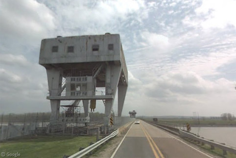
good coverage. I like this photo from street view of the Auxiliary Old River Control Structure (built to take pressure off of the under-designed and poorly maintained original ORCS) a bit better: https://www.googlesightseeing.com/maps?p=&c=&t=h&hl=en&ll=31.060287,-91.593361&z=13&layer=c&cbll=31.063722,-91.590201&cbp=12,7.7,,0,-3.58
I spent awhile browsing around the area to help clarify some of the news articles I was reading about the coming flooding. FWIW, the Old River Control Structure is so named because it controls the “Old River”, which is one of the natural outflows of the Mississippi.
Interestingly, the Old River and the Atchafalya River would be the primary outlet for the Mississippi River, if the Army Corp of Engineers hadn’t built this system. Baton Rouge would be left with no water, the end of the current Mississippi River would fill with salt water leaving New Orleans thirsty, and Morgan City would be underwater.
You’d think I might have noticed that the river in question was named Old River, rather than assuming it somehow indicated the age of the structure. Sorry for the shoddy research!
Just to the west of Hoop and Holler Bend is the start of the other main flood control structure built to protect Winnipeg, the Portage Diversion: View Placemark
This diversion works to protect Winnipeg much like the Morganza Spillway in that it takes water normally destined to flow through Winnipeg, and diverts it north to Lake Manitoba. View Placemark This lowers the flow and height of water flowing along the Assiniboine into Winnipeg, but raises the level of Lake Manitoba in return.
Unfortunately, the flood levels on the Assiniboine are so high this year (1 in 300 year flood), that the Portage Diversion cannot divert enough, so the cut at Hoop and Holler Bend creates a secondary diversion south of the Assiniboine, so that the waters meet up with the Red River instead of flowing through Winnipeg in the Assiniboine, thus helping to further reduce stress on dikes leading into the city.
Thanks Daryl. I just learned about the Diversion and was going to add it to the post. I heard on CBC this evening that the flooding isn’t nearly as bad as expected (3 sq km vs an expected 240 sq km) due to river levels not rising as much as was forecast. Explanation given was that a veteran forecaster with 40 years experience has retired, and the new forecasters weren’t as accurate!
but now apparently the banks/dikes of the Portage Diversion are apparently seeping, so they may have to reduce flows through it, and increase flows into the Hoop and Holler cut, southwards, which would increase the area flooded. They have certainly been working to minimize the flooded area, cutting roads around fields to try and direct the waterflow over the “waffle-iron” pattern of fields and roads, so this may have helped reduce the area.