Greenland (Island week 6)
Friday, 25th November 2011 by James Turnbull
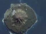
It's surprises me that in 6 years of island-themed posts, and our frequently-documented obsession with all things "largest", that the Google Sightseeing team have yet to feature Greenland1, the largest of all islands.

At its most northerly point Greenland is only 740km from the North Pole, and from there southwards it spans an enormous area – over 2 million km2. Unfortunately that space is largely uninhabitable ice, with the Inuit-majority population recorded at just over 56,000. This makes Greenland the least densely populated dependency or country in the world.
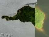
 In some of the stitched-together satellite photos you can see Greenland's huge seasonal shift.
Ittoqqortoormiit, one of Greenland's most remote towns, has a population of just 469. Coincidentally, this is also the number of people in the world who can correctly pronounce the town's name.
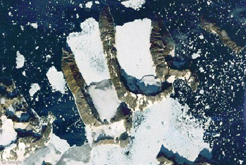
 Having an iceberg sitting outside your bedroom window must be an odd experience.
On the mid-west coast of the island we find Thule Air Base, which is part of the US Air Force's global early warning system, and their northernmost air base.
In 1968 a B-52 bomber crashed near the base, and there was some debate as to whether all the nuclear warheads were accounted for in the cleanup operation.

Even further north is Siorapaluk, which is the northernmost settlement in Greenland, and the whole of the American continent. During the height of summer the sun will stay in the sky for weeks on end.

Despite the name, Greenland has just one forest at Tasermiut Fjord, north of Nanortalik. After numerous failed attempts at forestry dating back to 1892, these willow and birch trees were planted in 1960 and first successfully harvested in 2005.

Naturally there's loads of information about Greenland on Wikipedia, but I encourage you to explore the satellite imagery of Greenland's frozen fjords, as there are some spectacular images to be found.

-
Earlier this week we looked at Greenland's Warming Island. ↩︎
yes great images, i tried to pronounce the Ittoqqortoormiit towns name and it take me 5 minute to understand that i can’t 😉
How come Australia doesn’t count as an island? The wikipedia page says “completely or mostly surrounded by water are classified as continents (when they are large enough) or islands” but doesn’t say what the boundary is.
Good question Craig. The answer is that yes, Australia is generally considered a continent, but the precise definition depends on whether you’re asking a geologist or a geographer…
http://en.wikipedia.org/wiki/Continent#Geology
Depending on where you live you may have learned that there are fewer than seven continents, but in any of the most widely taught definitions Australia is always considered a continent (although sometimes it is referred to as an “island continent”).
http://en.wikipedia.org/wiki/Continent#Number_of_continents
Craig, I’ve wondered that myself – it’s seems there’s been arbitrary decision to say what’s a continent and what’s an island. Australia is on one side of the divide – Greenland on the other!
Here’s a world map using the Dymaxion projection (showing the true relative size of all of Earth’s landmasses), which gives a proper idea of how much bigger Australia is than Greenland.
http://en.wikipedia.org/wiki/File:Dymaxion_map_unfolded.png
(Greenland in the very centre, Australia in the top-right)
I’ve always thought Australasia was the “continent” which includes Australia, New Zealand and a few other island nations.
wow!!! beautiful pictures. i really love those satellite kind of photos it remind me that we are so little in this universe.