Via Appia Antica
Wednesday, 19th September 2012 by Ian Brown
Via Appia (The Appian Way) was one of the earliest Roman Roads, running south-east of the Italian capital towards Brindisi. Via Appia Antica is the oldest section of the road, dating to 312 BC, and is lined with monuments and antiquities. We're able to take a detailed tour using a combination of satellite, 45° and Street View car and trike imagery. Travelling from north to south, we begin at the Porta San Sebastiano, a huge turreted gate in the city walls.
It's slightly inconceivable to those of us who live in much younger countries, but this ancient roadway is still in use today, so after passing through the gate, the first kilometre or so are busy with traffic.


However, it's just a matter of metres before we reach the first historical artefact - a column with a plaque identifying it as the location of first milestone of the Appian Way1.

A short distance later, the old road turns slightly to the left, and the Via Appia Nuova (New Appian Way - built in the late 18th century) runs parallel to it for a short distance.

At this intersection stands the Church of Domine Quo Vadis, constructed in the 17th century to mark the location where - according to the Acts of the Apostles - Saint Peter met Jesus.

A small doorway from the road leads to the small cluster of buildings around the Catacombs of Callixtus which contains the tombs of several 2nd — 4th century Popes.


Continuing south, we reach San Sebastiano fuori le mura (outside the walls) which is a large basilica and pilgrimage site, built over the catacombs of Saint Sebastian.


The Circus of Maxentius is a chariot-racing stadium built in the 4th century, and is considered the best preserved Circus in Rome.

The towers visible from the Via Appia Antica are thought to have been used to lift the starting gates to begin races. A road at the other end of the stadium gives a good perspective of the course.


The ruins of Maxentius' villa are mostly hidden by trees to the north of the stadium, while his son Romulus was believed to be buried in the tomb at its western end.


On a hilltop just to the south is the immense tomb of Caecilia Metella, whose husband worked for Caesar and whose son was a famous Consul and military general.

From the road we can see the fragments of the original building which have been restored, and the steps that the Street View trike had to negotiate when it was one of the four locations along the Via Appia Antica visited by the Street View Trike (Italian news article from 2010).

The trike operator's efforts allow us to get an excellent look at the interior.

The trike also visited the 2nd century Capo di Bove thermal baths complex, where we can even see some of the mosaic tile decor.

Continuing along, there are assorted ruins, reconstructions and artifacts which, while ancient, are apparently less significant than many of the major locations, and in many cases are not identified.


To the north of the road, the Villa of the Quintilii was so vast - including its own thermal baths and hippodrome - that the emperor of the day killed the owners and seized the property for himself.

At this point the Via Appia Antica is closed to cars, but the trike was able to get there ...


... then continued on to the largest tomb along the road, the Casal Rotondo which was built approximately 30BC, though the farmhouse on top was built in the Middle Ages when the structure was used as a watchtower.

Nearby is a wall supposedly containing fragments of the tomb's interior, though their origin is now uncertain.

From here on, the road continues to the south-east, but there is no Street View coverage. There are still a number of important monuments, including the Torre Selce, a 12th century watchtower.

A few kilometres further south, the route of the Via Appia Antica is still clearly discernible2, but before long it is lost all together, taken over by modern roads and buildings. Roads do follow the route of both the Via Appia Antica and Nuova for some distance, including what is claimed to be the longest stretch of straight road in Europe, at 62km (39 miles).

The road originally continued, through hills and across marshes, some 370km (220 miles) to Brindisi, where a column supposedly marks the end of the road, though it may actually only be a tower used by ships to navigate into the harbour.

For more about the Via Appia Antica, Wikipedia has a good article with more details about many of the monuments, and the official website has some good information and pictures.
-
Presumably the column is a replica. ↩︎
-
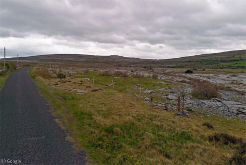
Sometimes a particular scene leaps out at me from the millions (billions?) of images captured for Street View. This misty morning along the Appian Way is one of them. The vivid green grass and vague shapes of trees in the mist, offset by the sharp brown of the fence... just lovely. ↩︎
About the author
Ian Brown lives in Ottawa, Canada, and spends his spare time perusing maps to find new routes to ride on his orange bicycle.
A quick search hasn’t turned up anything definite, but I’m pretty sure I remember one of the Top Gear boys (probably Mr Clarkson) driving along part of this in a Supercar. Apparently the suspension on that car was a bit too low and stiff for the Roman paving techniques ..
Found the clip 🙂 The part on the Via Appia starts at 4:00 Oh … and it was Mr May rather than Mr Clarkson.
Top Gear clip
Very cool post Ian!
Thanks Chris!
And thanks Tammo – the clip is excellent! “Err… I’m going to be overtaken by a Smart Car!”