The War of 1812 – USA
Wednesday, 22nd August 2012 by Ian Brown
We recently took a look at important Canadian battlefield locations from the War of 1812, as well as a number of memorials. As a follow-up, here is a collection of equally-important sites in the USA, where the War covered a huge area, from the Great Lakes and mid-west, to the east coast and the deep south. We begin with Fort McHenry in Baltimore1.
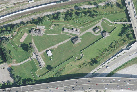
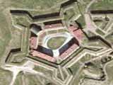
The distinctive star-shape of Fort McHenry, with the surrounding trench, was designed to allow effective defense from a land-attack, while the fort served its main purpose of defending Baltimore harbour from a naval attack. This it successfully did in mid-September 1814 when US forces were able to repel an attack by the British Navy, despite being out-gunned.
Seeing a large American flag fly proudly above the fort following the heavy artillery bombardment inspired Francis Scott Key to write a poem titled "The Defence of Fort McHenry", later retitled "The Star Spangled Banner", which over time was set to music as the country's national anthem. The flag is now displayed at the National Museum of American History in Washington D.C.
A statue of Orpheus on the grounds was commissioned a hundred years later, to honour Key and the soldiers who valiantly defended the fort and harbour.

Fort McHenry is a national park and the only location in the country to be jointly designated a National Monument and Historic Shrine. When the 49th and 50th states joined the Union, the newly-redesigned Stars-and-Stripes flags were flown for the first time over the fort. Historical reenactments are held here regularly, and every September the city holds a large celebration of the fort's history: Defenders Day.

In downtown Baltimore there is a large monument which honours those who died in the battle. The 18 layers of stone at the base of the monument represent the states which made up the Union at the time.

There is also a memorial to Key, depicting him in a rowboat returning from seeing the flag being raised, and the house where Mary Pickersgill made the flag is a popular museum.


In Boston Navy Yard, we find another American icon of the War of 1812 - the distinctive three-masted frigate USS Constitution. While Street View only gives us a glimpse of the bow and masts, the 45° imagery allows us a good look at this historic vessel whose name was selected by President Washington and which is the oldest commissioned naval ship still afloat.

Launched in 1797, the Constitution had already seen heavy action in the Mediterranean2 but the War of 1812 sealed her legendary status, with the defeat of five British warships and the capture of numerous other vessels. Her 53cm (21-inch) thick wooden hull withstood attack so well that she was nicknamed "Old Ironsides".
At the time most wooden naval vessels would only serve for about 15 years, but the Constitution saw active service until she was retired in 1881. She was made a museum in 1907 and regular restoration work has always been required to keep her in good condition, and a major reconstruction (where the aim was to keep the ship as close to the original design as possible) was actually able to get her sailing again for her bicentennial celebrations in 1997.3
There are remnants of forts along the New England coastline, and monuments in many small towns that saw action. One example is in Stonington, CT, where a pair of cannon flank a monument topped by a cannonball.

A decisive battle on Lake Erie in 1813 saw a fleet including the USS Niagara (under the command of Oliver Hazard Perry) defeat a significant number of British warships to secure US dominance in the region. The Niagara was taken out of service and sunk in 1820, refloated in 1836 but soon resunk. After being refloated again in 1913, and following considerable restoration work, she has been on display in the city of Erie. While she must have been out on the lake when Google's images were captured, Niagara can be seen on Bing, as can the large beacon memorial to Perry on South Bass Island.4


There is also a memorial to Perry in Cleveland, and another in Buffalo. The latter is in the middle of a large paved area 'decorated' with interesting tire tracks.


As we saw in the Canadian post about the War of 1812, the areas around Lake Ontario and the Niagara and St Lawrence rivers were the sites of some of the most intense fighting. Across the Niagara from Canada's Fort George, the Americans had Fort Niagara. Originally built by the French, the Fort and surrounding area were ceded to the US following the War of Independence.

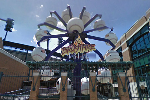
On the south shore of the lake, Fort Ontario was built by the British in the mid-18th century, destroyed by the US in the Revolutionary War, rebuilt by the British but ceded to the US after the War of Independence, then again destroyed by the British in the War of 1812. After this turbulent history, the only threat to the rebuilt fort these days are stray baseballs from the diamonds across the street.

Further east, near the mouth of the St Lawrence, the US had their only deep water port on the lake - Sackets Harbor, where a large ship yard was constructed despite the remote location. The importance of the site meant it was heavily defended. The British, realising its significance, attacked twice but were defeated both times.

One of the darkest periods of the War of 1812 for the American forces was the loss at the Battle of Bladensburg, following which the British forces burned many notable buildings in Washington DC, including the White House, the Capitol and other government buildings. Not surprisingly, there are few memorials to these events.
In the South, the US forces didn't just have to fight the British. At the Battle of Horseshoe Bend in Alabama, Andrew Jackson and his men defeated a band of Creek Indian rebels known as the Red Sticks.

The War of 1812 ended with the signing of the Treaty of Ghent late in 1814, however word didn't reach forces in the south until several weeks later. In the intervening time, the Battle of New Orleans took place in Chalmette, with a resounding victory for the US forces. The site is preserved as National Historical Park, and has a large monument. Alongside is the Chalmette National Cemetery where more than 15,000 soldiers from numerous military campaigns are buried.5

As we've only visited locations with a presence on Google Maps or Bing, this post cannot serve as a detailed history of the The War of 1812, so to learn more about the war in the US, the US Navy site Our Flag Was Still There has some good information, as does this PBS site.
-
Fort McHenry was one of the earliest locations featured when Google Sightseeing was launched back in 2005. ↩︎
-
in the First Barbary War and the Second Battle of Tripoli. ↩︎
-
Do any locals know if the grey covering shown in the 45° imagery was part of the 2010 renovation? Or is it perhaps a cover put in place to protect the ship during the winter? ↩︎
-
Which was also featured in our recent post about the World’s Tallest Lighthouses. ↩︎
-
Zoom in for 45° imagery. There's also Street View shown on the path that loops through the site, though at the time of writing all the images were blacked-out for some undisclosed reason. ↩︎
About the author
Ian Brown lives in Ottawa, Canada, and spends his spare time perusing maps to find new routes to ride on his orange bicycle.
The covering on the Constitution was part of the most recent restoration, yes. Note also the lack of topmasts and rigging. The restored vessel was taken out for a brief sail last week (for the first time since its 200th anniversary in 1997) to commemorate the anniversary of its victory over HMS Guerriere in 1812.
Your forgetting the River Rasin battlefield in Monroe MI and Fort Meigs in Perrysburg Ohio also Fort Malden in Amherstburg Ontario
What about Macinac in Michigan? That was also a fort that was given up in 1812 to the British.
What about Macinac in Michigan? That was also a fort that was given up in 1812 to the British. http://www.historyofwar.org/articles/battles_mackinac_island_1812.html