‘A’ Mountain & Sun Devil Stadium
Thursday, 12th May 2005 by James Turnbull
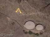
Tempe Butte is more commonly known as "A Mountain" - for obvious reasons. Each year in the run up to the Arizona State University vs. University of Arizona football game the ASU students take shifts to guard the steel and concrete 'A' from being painted a different colour by the rival team.


Colorado School of Mines in Golden, CO, has a big ‘M’ on a mountain over the city:
View Placemark
I can tell you right now that parking there isnt cheap, you end up parking up to 2 miles from your class, and they continually decrease the number of spaces, increase the price, and turn needed parking lots into high price condos for profit at our expense.
If you scroll up to the river, you’ll notice some ghosting effect, with one side of the bridges not quite matching the other.
Then following the ‘dry river’, to the left, and on the other side, there is a nice ‘circular’ something!
rayray hit it dead on–parking at ASU sucks.
The dry river is the Salt River, which is now damned several times and only flows when Salt River Project allows it to. Tempe Town Lake now occupies the riverbed directly north of the stadium, but the water in it is transported from the Colorado River. As a result of the lake, ASU now sports a rowing team.
The circular something is just freeway landscaping.
Go North west of this location and see this triangle. What is this for?
View Placemark
Other interesting sites nearby:
To the southwest of the “A” is a diamond-shaped building. That’s Tempe’s city hall, and it’s actually an inverted pyramid.
South of there a few block (where the road, Mill Avenue, arcs to the east becoming Apache) is Grady Gammage Auditorium, a rather nice Frank Lloyd Wright designed building (which isn’t all that impressive from this viewpoint)
East of campus by an Arizona Public Service (APS) plant are three big water towers, which sport “ASU”, “Tempe” and “APS” logos on them.
SE a bit is a geodesic dome that used to be a bank (don’t know what it is now) that kind of shows up on the map (View Placemark)
The weird triangle mentioned by the Govinator is an auxiliary landing strip that used to be used by Luke AFB. I’ve been out there, it’s literally nothing but three asphalt strips in a triangle.
See http://www.airfields-freeman.com/AZ/Airfields_AZ_Phoenix_NW.htm for more info. If you look around on Google Maps, some of the other Aux fields are around, too, like #3, View Placemark, which has been dveloped, with #2 being slightly NW of there.
Wayne, C’mon now, that’s a ‘W’….for Wayne. How did you pull that off?
Missoula, MT also has a big “M” on its near by mountain:
View Placemark
The dome is a welcome center for ASU.
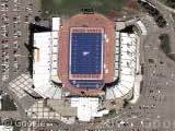
You can also find the Bill Kajikawa practice field to the east of the stadium…notice the SUN DEVILS written in the end zone.
The triangle looks like maybe a former emergency airfield? http://www.topozone.com/map.asp?z=12&n=3734952.00004448&e=348679.999995577&datum=nad83&u=5
As for the “nice circular something” (you mean View Placemark , right?), I noticed that the Phoenix area does a lot of that sort of thing in the rockery and dirt next to its highway offramps and interchanges. I submitted a ton of links to those a while back, maybe they’ll appear here someday. Like View Placemark or View Placemark I seem to remember one on one of those roads somewhere where the designs on the sides of the interchange look like lizards, but I can’t find it.
If you go North and a bit west along the northern shore of the lake/river – you’ll see a mismatch in the pictures lining up. It goes pretty east…not sure about west….check it out.
Check out the REAL A Mountain in Tucson, AZ. Univeristy of Arizona
View Placemark
Eu acho tudo isso muito legal…. o que está na foto é parecido com a letra A… legal… adeus!!!
Keith T., you can see some of the freeway lizards about three miles east of this shot, if you follow the 202 (Red Mtn Freeway) to Dobson Road.
Parking space is another problem for students, as it has always been… No such this as a perfect school, right? That’s why they can just take advantage of the nearest free space nearby.