UFO
Thursday, 12th May 2005 by Alex Turnbull
Tensuns says:
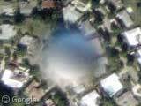
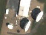
I have no idea what this is. I can’t find anything similar on any google map referenced sites. It doesn’t show up on terraserver and I live nearby so I know there are no towers in that area. It has the same shadow as ground objects and when you zoom out it appears to be too small to be something really close to the satellite.
Well we're completely stumped. Any clues anyone?
Update: See the UFO Update entry.
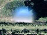
where is the shadow?
Yeah I wasn’t sure about that either. I just posted what Tensuns said verbatim, perhaps he can clear it up? Sure is weird though…
Mat, See how it is lighter/brighter on the southwest side of the orb as if the sun is in the southwest. And if you look at the trees in the background they cast their shadows towards the northeast, implying that the sun is coming from the southwest also.
I take it as futher evidence that whatever it is, it probably isn’t a defect in the film or some object obfuscating the lens.
High altitude weather balloon maybe, if the lens is focused on the ground, that could be the reason for the fuzzyness of the object.
Is it possible that it could be space debris? I know there is a lot of stuff just out there is space.
And i looked at Terra Server and nothing is there
Yeah, a weather balloon, that what you WANT us to think it is 🙂
90% of UFOs are weather balloons
and 73% of statistics are made up
I used to live in that area- West Palm Beach, FL. It’s definetly not anything on the land there!
Also, Notice how it overlaps the adjacent housing. My buck goes on weather balloon.
It is just a weather balloon. You didn’t see anything.
I am no astronmer but could it be condensation on the lens?
That has to be where the Crossbow Project laser hit that poor bastard’s house, filling it with Jiffy Pop.
I guess including links forced my previous comment into a moderation queue, so I’ll post again with out links.
I not exactly sure what this is but I believe it is caused by something either on, inside or very near the lens since you can find more of them at right angles of each other. I’m going to dub them FloridaSpheres. You can find a similar FloridaSpheres exactly exactly due west (FS1) and due north (FS2) from the one pinpointed above (FS0). Just keep clicking the west or north arrow and you will reach it. I’ve found more using the same search pattern. Below is the latitudes and longitudes of other spheres. Copy&Paste the numbers into the appropriate place in a GoogleMaps URL.
ll=26.748651,-80.074550 FS0 – The Original FloridaSphere ll=26.748651,-80.189370 FS1 – Due West of FS0 ll=26.901956,-80.074550 FS2 – Due North of FS0 ll=26.901956,-80.245299 FS3 – Due West of FS2 ll=26.901956,-80.302420 FS4 – Due West of FS3 (Partial) ll=26.901956,-80.357441 FS5 – Due West of FS4 (Half) ll=27.002249,-80.245299 FS6 – Due North of FS3
I believe one of the engineers shot a spit wad at another when they were building the satelite and it stuck to the lens……..or maybe like on your vehicle windshield at night one of the unlucky insects bit the winder “lens” in flight…. you know space insect…..:)
After reading all of these comments-i believe it is a weather balloon or something of the sort. Florida has definatly had its fair share of hurricanes and storms and such. If I were in charge of Florida, I’d have lots of detection mechanisms watching for the first sign of messy weather. and theres always the irrational explination- aleins and UFOS, burmuda triangle, jeb bush, etc etc
They’re all in alignment with each other. I’d bet they’re alignment points for the map data.
If you zoom out to the 3rd level and scroll left/right and up/down in a straight line, they form a grid.
View Placemark View Placemark View Placemark View Placemark View Placemark View Placemark View Placemark
Note also how they’re more or less identical in shading. Light on the bottom, dark on the top. #4 above and #7 above are partially overwritten by new data.
How high do weather balloons go? The top side of it is shaded sky-blue, so if weather balloons still fly low enough to have blue sky above them (and thus reflect it in this direction), then I’d say it’s pretty darn likely to be one.
It’s obviously an Unidentified Flying Object.
If it forms a grid, then something’s a little odd. I would have said it could be a decloaked bouncer…. or baloons, or just the same object drifting fast enough to get tagged by the same satellite?
Given that it’s blurry all the way around it, it’s not motion blur (unless it’s moving up or down really fast or really close to the lens). Motion blur occurs because something is able to travel the distance of the blur in the time it takes to expose the sensors to light. You’d only see blur where the object has temporarily obscured the background at some point during its travel. More likely it’s simply out of focus, which implies that it’s at a significant altitude, probably nearer to the camera lens than the ground.
Given that other posters have found a grid-like relationship to them, it seems likely that it’s something that has condensed/frozen/landed on the lens itself and every photograph taken has this same dot in the same place. I suppose it’s possible that whatever it is is in orbit with the satellite also, but I would expect at least a little relative drift.
Didn’t you see Independence Day (or was it Signs)? They’re in a grid because they’re positioning themselves for an attack!
Prettier than Vogon ships, anyway.
It’s a flying crop circle without the, er, crops.
Weather balloon. Photographs at this scale aren’t taken by satellite, but by aircraft. A balloon would be close enough to the plane (relative to the distance to the ground) to be out of focus.
Maybe it’s a planet :S (showing my ignorance now, perhaps)
Oh no, not a planet! What am I saying?! Just had a closer look on Google Maps. Weather balloon I think.
To my mind a meteorite or spacial garbage has been impected to the camera, and this is making wrong fotos.
it’s just force field around my house
>>They’re all in alignment with each other. I’d bet they’re alignment points for the map data.
Well, it’s obviously a well organized invasion…
They look just like the space craft they used in “V”. It must be space nazi lizards, it would be too much of a coincidence to be anything else.
Oh, there’s where my ball bearing went.
Gabriel, Josh, Jtk, Jared, all you guys – this has been the funniest thread I’ve read in ages. Geniuses, the lot of you 😀
Executives at Google are going to be annoyed when they hear you’ve spoiled the launch of their Google Thumbtacks Beta.
Its a Giant Chewy Peppermint.
Now where’s Mulder when you need him?
Mentos, the Freshmaker!
it looks like a plume of smoke.
It’s a small pond or drainage area of some type….notice the shadow in the top right cutting across the surface, also notice what appears to be a sand shoreline in the top right quadrant at the edge and it appears to have the start of considerable weed growth or an algae bloom at the bottom. Nothing to see here…move along.
Mars attacks!
Know of many perfectly round ponds that bisect homes in subdivisions, do you?
While I’ve seen some highly convincing evidence for UFOs and am actually one to believe in them, this just appears to be a weather balloon or something similar (and hey, I’m not the FBI saying that, so I swear there’s no agenda!).
One thing to keep in mind, though, or so I think, is that our military, for better or worse, is always experimenting with new devices; sometimes we become aware of it by a fluke of timing. Where I live currently, we are having daily sonic booms that rattle our houses; we’re just a tiny town in the mid-south. Nevertheless, the military or some other government facility has deemed this place as appropriate for such testing. It’s hard to say what sort of balloon, if a balloon, that is. It doesn’t remind me of any of the research reports (from more stable people, mind you, haha) that go into detail about UFOs. The design tends to be sleeker.
Duh, it’s just swamp gas.
Hey everyone,
some thoughts about the air baloon theory: if you compare images of airplanes photographed by this sat, their size is at most half of this baloon’s diameter, meaning that if this object is at the same altitude as airplane is, its at least twice bigger. In order to appear this big on this picture, the object has to a) either really be very big, or b) be astonighingly close to the lense. Given that this sat should orbit at around at least 150km and atmosphere ends at about 80-90 km, I’d say this object must be at least about 50-60 km from the lens.
If anybody knows anything about sat optics and can suggest whether or not a 2m diameter weather baloon can appear this big from 50km distance, plz comment! 🙂
After an EXHAUSTIVE SEARCH of the ENTIRE AREA, I found one more point. I’ve logged all of them and grabbed a 90×90 framegrab of each spot, merged all 8 points together into a single image and plastered it on my flickr account. Have at:
http://www.flickr.com/photos/44276669@N00/13645955/
One thing is certain: it’s not condensation on the lens; one of the nice thing about space is it’s vacuum property. And the satellite’s internals were no doubt vacuum sealed on earth (otherwise there’d be a serious pressure imbalance up there). So yeah, no water molecules in the way.
if its on the lens, its moving. You can see that in some pictures it is cut off meaning it is at the very edge of one picture half out of the picture. This would mean it would have to be far to the side of the lens although in other picture it is clearly right in the middle of the photo and therefore the lens
Given that at least a couple of them seem to be partially obscured by trees I’ll go with an anomoly produced by the photographic production process. No way it’s a map alignment thing else they’d be found elsewhere.
…or. This is the beginning of a radioactive grid being placed near the surface via an elaborate underground network of Muslim extremists determined to slowly wipe out the Jewish and infidel population in Florida so it can be populated by flying students.
Swamp gas from a weather balloon got trapped in a thermal pocket and refracted the light from venus.
¡¡VAMOS A MORIR!!. WE ARE GOING TO DEAD!!
Does anyone know if these photo’s where taken by aircraft or by a satalite? And if so, what type of aircraft-mounted camera was used?
I’m thinking there might be something close to the camera, that is interfering in some way with the lens, or something. Just like the VHS-cameras that all showed footage of flying saucers, and later they found out it where reflections on the shutter of a perticular type of camera, producing the same ‘UFOs’ all around the world on peoples home-video’s.
That combined with the effect seen in some quicktime VR’s, where if you look all the way up or down, you’d see some blurry circle because there’s no image of that spot…
No… probably just weather balloons.