Juscelino Kubitschek Bridge
Friday, 24th June 2005 by Alex Turnbull
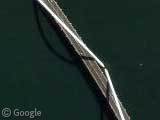
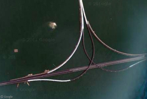
We have no idea where exactly this is (lack of map data makes it a little tricky to work out), but check out the totally cool bridge somewhere in Brazil! Best shadow yet I think.
If anyone knows what and where this is, please let us know in the comments. Cheers 🙂
Update: Thanks to our helpful readers, we now know that this is the Juscelino Kubitschek Bridge which crosses the Paranoá Lake, in BrasÃlia. There's an absolutely stunning image of the bridge available here, and another here, but the Wikipedia page is a little lacking. If interested, you could also read this article about it though.
There's also some fascinating stuff in the comments thread about the construction and design of Brasilia itself.
Thanks to Ben Singleton and everyone who commented on this one! 🙂


Some googling turns up that it’s the President Juscelino Kubitscheck Bridge in Brasilia: http://en.wikipedia.org/wiki/Juscelino_Kubitschek_bridge
Pics here: http://www.architectureweek.com/2004/0609/design_1-1.html
Very cool
It’s somewhere north of the capital Brasilia, it seems.
I’m pretty sure that’s Brazilia.
check this: http://www.brazilia.jor.br/Historia/img/oldMapLago.jpg
It is Brasilia. Note the formal spaces. Also there is one tall tower here: View Placemark The airport is being expanded: View Placemark
“Juscelino Kubitschek Bridge, inaugurated in December 2002. It is also called ‘3ª Ponte’ (‘Third Bridge’) or ‘Ponte JK’ (‘JK Bridge’).”
Good picture
This is the Juscelino Kubitschek bridge that crosses the Lago Do Paranoa. Great land shot can be found here:
http://vortex.hawkworld.net/gallery/argbraz03/DSC01034?full=0
It’s the President Juscelino Kubitscheck Bridge in Brasilia – AKA: The JK Bridge.
http://www.architectureweek.com/2004/0609/design_1-2.html
It’s beautiful!
I concur. Actually, I was just reading about Brazilia, and it has a very interesting story. It was meant to help spur development of the inland, and was build in something like 3 years from start to finish. It is a planned city. Oddly enough, I had already looked it up on google maps, and I also noticed the bridge.
About it being a planned city- I heard somewhere that the city is shaped like a bow and arrow, which is obvious from this view.
View Placemark,.170803&t=k&hl=en
this bridge is located in my city 🙂 brasilia
Brasilia easily recognized by the central city’s airplane-shaped layout visible just west of the bridge: View Placemark (known as the “Plano Piloto”).
Brasilia is famous for the ultramodern (at the time) architecture of Oscar Niemeyer, and the wacky-looking bridge seems to fit that scheme.
Also it was designed by Oscar Niemeyer.
About what Tim said, it’s not a bow and arrow, it’s a plane. The city was designed by many architects, mainly Oscar Niemeyer, in the “Pilot’s Project” (have this name because of the plane shaped city).
Also, it is divided in the Left Wing, Right Wing and the body of the plane that have the federal and administrative buildings of our Capital (President’s House, Congress, Ministeries, and other).
It is considered by some geographers as the only “artificial city” in the world, as it was planned AND built before people start living there. It’s the first and only (at the moment) with this caracteristics.
So what is this VERY tall shadow? It appears to be opposite to the shadows on the buildings just south of it. View Placemark
That is the Brasilia TV tower. 218m tall. Picture here: http://www.geocities.com/TheTropics/3416/torre_bl.jpg
Yes that bridge is in Brasilia, Brasil. I drove over that bridge a few times in 2003. The light-colored diagonals are suspension loops that arch over the roadway. The bridge cost a lot of money, and some Brasilians think a simpler bridge that cost less would have been more appropriate, but others love it.
Yes, that’s the JK bridge… This lake you see there, is also artificial.
da ora…
escrevam em portugues tb po!!!
I live in Brasilia and I want to correct what Bruno said earlier:
There is no proof that the urbanist Lucio Costa wanted to make it look a plane. The name “Plano Piloto” is commonly mistranslated to “Pilot Plane”, but the correct translation would be “First Plan” (Plan in this case being a method, something conceived beforehand) what it really is. And it´s not divided by Left and Right wing, its North and South wing because the are really aligned to north and south like the most locations in the city: North lake, South lake, SouthEast habitation sector (some literal translations of the places), South commercial sector, and goes on.
Well, this bridge connects the “main” city to the Habitational sector called South Lake. You can see that in this map View Placemark where the Shout wing is in the upper left and you can see the three bidges connecting it to the South lake (and the JK bidge being the upper right bridge). The South Lake is an sector where only houses can be built and where some of the richmost people here lives (or the first one that came here when all areas to live where cheap) and its one of the most expensive m² in the brasil (losing to the av. paulista). People and the media says that the construction of this bridge was used to deviate money (a common and sad practice in this country) from the livings here and blame the governor (because we don´t have a mayor, instead we have a governor that do the same job) Roriz for it.
And to correct Bruno again: the city wasn´t all built and the people started to live here. Only the administrative (because its now the capital of the country) and the vital organic pieces of the city was built beforehand. All the rest is being built until today (there is a building next to my building that was finished this year). But the city were all planned, that means: all buildings have an certain place and lots of restrictions that the constructor must follow. The most famous one is that the buildings in North and South asa must be 6 or 3 floor (depending the area, the most near the lake must be 3 floor only because the lake makes the soil less consistent and a 6 floor building would be afected by this).
Well, I think I wrote much. Sorry for all the “because” in parenthesis, but they were all needed to understand a little more of the city.
Another interesting urban planning trivia fact is that Brasilia was originally designed in a way that there would be no intersections w/ traffic lights, if you zoom in closer in the residential areas in the “airplane” shaped sectors of the city, you’ll see a lot of roundabouts, merging lanes and overpasses… the city’s growth has proved this orginal idea to be unfeasible, and traffic lights are now found in many areas.
About Bruno’s comment that Brasilia is the only city that was build before people begin to live there, that’s not true, there’s another city also in Brasil and very close to Brasilia called Goiânia, the capital of the State of Goiás, it was also completely planned before people begin to live there, but unfortunately Google hasn’t got the full-zoom image yet of this city.
JK Bridge looks nice.
Are you sure Goiania was made before people moved in there? I don´t think so… it´s not completely planed like Brasilia…
My city is he best of the world… i live in rio de janeiro since i was born… for is the most beautilful city… the problems is the violency =/
i LIVE IN BRASILIA, IS WITH S!
Goiania was not built before its ocupation. Goias and its capitol can be found in really earlier brazilian history, when Goias still was part of a grand Mato Grosso State. What happens is that Goiania had a reurbaned planning, of really huge amount, like happened with brazilian city of Belo Horizonte, capitol of the state of Minas Gerais.
Brasilia is internationally known as the biggest project of that kind in the world history. Oscar Niemeyer, of course that not alone, draw almost the entirely First Plane of that city.
It is said that brazilians attempts to enter modernity in the begining of 20th century were strongly influenced by the positivism, wich defends a conscient and before-planned construction of the society. Since the 1910s, talks about transfering brazilian capitol from Rio de Janeiro to the interior central area took place at brazilian geopolitic thought. And in 1950 it started to be done.
Sorry Fabricio. But Goiânia was in fact planned and reurbanned years after that. The former capital of state was “Goiás Cityâ€?, and Goiânia was built to be the new capital of Goiás State. In effect, the city grew a lot and the planned was not respected. In BrasÃla, same in the present the original plan has to be respected.
It was in 1823 (just one year after the independence of Brazil) the fist idea of transferring Brazilian capital from Rio de Janeiro to a central area, but just on the next century the project of build was started.
Beyond BrasÃlia, Belo Horizonte and Goiânia, there is another artificial capital city in Brazil: Palmas (capital of Tocantins State) which was built in 1990.
Yes, it’s Brasilia! (write with “S”)
http://www.brazilia.jor.br/Vias/ligaPonte3.htm
http://www.brazilia.jor.br/Vias/ligaPonte3a.htm
http://www.brazilia.jor.br/Vias/ligaPonte3b.htm
http://www.brazilia.jor.br/Vias/ligaPonte3c.htm
“brazilia” with “Z” is wrong….
In fact, TERESINA (capital of State of Piaui) was the first planned city in Brazil (earlier than the well-known planned capital city of Brasília, founded in 1960, and Belo Horizonte, capital of the state of Minas Gerais, founded in 1897). It was founded in 16th August 1852 by Conselheiro Saraiva. But I think even Brazilians don’t know this fact… Read more: http://en.wikipedia.org/wiki/Teresina