Tacoma Narrows
Wednesday, 1st June 2005 by Alex Turnbull
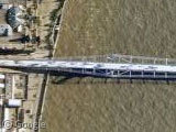
This is the Tacoma Narrows Bridge, which is the replacement for the original one which famously collapsed on film in 1940 (the link is to the movie on Wikipedia in ogg format, there's loads of statistics there too).
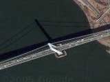
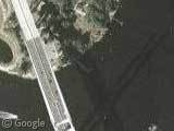
What's really cool is the incredible angle on the West part of the bridge! Compare it to the East side, pretty crazy image huh? Cool shadow too.
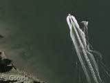
Also, just to the West is the Tacoma Narrows Airport, which has some great large type, some cool looking planes, and should be well known to any Microsoft Flight Simulator lovers out there 😉
Thanks to Scott Foster and Ivan M.
<img src="http://www.googlesightseeing.com/wp-content/images/tacomanarrowsbridge.jpg" <img src="http://www.googlesightseeing.com/wp-content/images/tacomanarrowsairport.jpg"


The Tacoma Narrows Bridge pic has to be from an airplane. Or one lucky satellite that flew right accross the middle of the bridge.
I think that I read somewhere on here that all of the high-res pictures are taken from airplanes rather than satellite.
I also noticed that you can see the inside of each of the support towers on the bridge.
Wish they would get some recent pictures of the new bridge going up next to it, its really amazing looking down on the ground… HUGE project in the works for SR16 out to the Gig Harbor/Key Peninsula!
Some quick google bridge dimensioning, photoshop measuring, and back-of-the-envelope number crunching puts the camera elevation at only around 5000 feet. Wow!
I thought of an easier way to figure this, and got the same number. Here’s how:
I photoshopped together the left and right side images, and used the Measure Tool to find the length in pixels of the center span at the deck (874.57) and the length between the tops of the tower (933.45). The center span is 2800 ft, so divide 2800 by each of these by the pixel measurements to find the number of feet in one pixel at deck height and 309 feet above deck height. Subtract to find that each 309 feet of elevation (that’s the height of the tower) decreases the number of feet per pixel by 0.20194829… Divide the deck resolution (3.201573 feet/pixel) by this number and multiply by 309, and you get 4898 feet. Add the height of the deck (which I can’t seem to find right now, but around 100 feet) and the plane is at almost exactly 5000 feet.
Whew!
Also, unrelated, construction on a parallel bridge started in October 2002, to be finished in 2007. The towers for the new bridge should be finished around now..
This is an excellent example of some of the strange things that can happen when aerial photos are orthorectified. I think google’s imagery for Tacoma, and many US cities, comes from the USGS orthoimagery, which in turn comes from a variety of sources, all airplane flown (and should all be online in the USGS National Map).
The closer your camera is to the ground, the greater the distortion you get from changes in ground elevations. These distortions are more pronounced the farther from “directly under the camera” a feature is. You can tell that the Tacoma Narrows Bridge was not directly under the camera (very little ever is) because you can see the sides of the towers. That is, you aren’t looking straight down.
Aerial photos are orthorectified to be made “map like”. The prefix “ortho-” implies “right angles”. Spatial distortions caused by features not being directly under the camera are corrected through some image processing magic, resulting in an image that is “as if” you were looking straight down at every point (“orthographic”). But since the camera was not in fact looking straight down at every point, weird artifacts can result.
More weirdness can occur when the images are processed to remove distortions caused by changes in landscape elevation. A hill that is not directly under the camera will end up farther from the photo’s center than it should be in an orthographic map. I think this is a form of foreshortening. These distortions are removed with more magic, using terrain elevation models. These USGS orthos use the USGS DEM elevation models, I bet. The newest generation of orthos are starting to use extremely high resolution LIDAR data instead. But in either case, bridges are trouble.
The elevation models of the Puget Sound Narrows don’t take the bridge into account. So when the aerial photos are orthorectified, the bridge ends up running right down the coastal bluff and across the surface of the water, and back up the bluff on the other side. This is quite clear when viewing the bridge in Google Earth (with the elevation exaggeration turned up). It looks quite silly!
This is also the reason there are two “shadows” under the bridge. One shadow that is clearly that of the bridge. You can see the towers and cables and everything, shadowed onto the water. The other shadow is closer to the bridge, and completely black. That shadow has been painted in by someone to cover up the artifacts caused by orthorectification. Since the terrain models omit the bridge, it ends up “corrected” to the surface of the water, with a crazy twist at either end where it crosses the coastal bluffs. This was corrected, probably by hand. The bridge was moved so the twists at either end went away and the road looked straight, as it would on a map. But that left a gap in the image, which was filled in with black pixels.
Another curious artifact of the orthorectification process you can see involves the cables. While you can see both the main cables in the shadow of the bridge, only one of the actual main cables is visible. I think the other got mangled when they adjusted the bridge’s position and filled in the gap with black, and they didn’t bother to try to draw in a new cable over their black pixels.
I work near the bridge, doing GIS stuff, and staring at lots of orthophotos. That’s how I came to learn all this stuff. I even have some related images on the topic:
The bridge in Google Earth: http://seattle.gii.net/~pfly/ge-narrowsbridge.jpg
The bridge in other orthos: http://pfly.org/misc/narrowsbridge.jpg
Fun fun… pfly
I just stumbled across this, and noticed the image anomaly while, ironically, gathering high-resolution satellite imagery for a Flight Simulator scenery project.
The Tacoma Narrows Bridge towers in the images are not totally accurate. The real Tacoma Narrows Bridge (er, the existing one built in 1950), each has a set of three twin-X-brace setups above the road deck. This can be easily seen by doing an image search on either Yahoo! or Google. The aerial image of the bridge as seen on Google Earth isn’t accurate, as it depicts five twin-X-brace setups.
Something to consider in this debate.
Also, in the real shadow, the cables are (correctly) attached to the top of the towers. In the image of the bridge itself, the cables are attached to about the middle of the towers, while a little snippet of cable comes out of the top. It appears the top part of the towers was doubled to meet the top of the black false shadow on the water.
Would love to go go to Tacoma . I am building a 737 throttle for my sim and am looking for some spar parts , anyone got any ideas? i hear ther is a parts retailer there.