2nd Annual Google Sightseeing Volcano Day!
Tuesday, 20th June 2006 by Alex Turnbull
I can't quite believe it myself, but despite what I said a year ago today, the 2nd (and now actually annual) Google Sightseeing Volcano Day is upon us!
Things have changed on Google Maps a lot since then (and even more so on Google Earth), including image updates for some of the volcanoes we featured last year, so that's where we'll start.
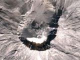
Mount St. Helens (Wikipedia page) isn't yet in full high-res, but the imagery is much better than it was last year. Very cool when you zoom in a bit.
I was going to feature Krakatoa today by the way, but it seems that the images which people described in their submissions have been removed - it doesn't feature in Google Earth either unfortunately, so it'll just have to wait till next year :-/
More later!


Funnily enough, I was looking at Mount St Helens only the day before yesterday, now that I can finally use Google Earth! It must be the most impressive place I’ve seen so far, particularly the way the initial zoom takes you right inside the crater! I wish they could include historical data of what it was like pre-1980 (something it will obviously never be possible to see in real life!)
In this picture of the Etna ypu can actually see lava streaming down the volcano … https://www.googlesightseeing.com/maps?p=&c=&t=k&hl=en&ll=37.744657,15.007324&z=13