Square Circle, Saudi Arabia
Friday, 30th June 2006 by Alex Turnbull
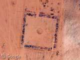
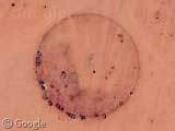
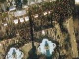
Here in Saudi Arabia, there's a large square with a smaller circle inside it. Um... yeah, I really don't know what this place is!
It's just outside of a small town, and the square is about 500 metres across, defined by walled(?) areas which sometimes contain small buildings. Some sort of compound? An empty and organised shanty town? A very tidy dump?
But the weirdest thing is course, is the totally bizarre colour scheme. Whaddup with that?
Thanks to Uri.

My first guess was some sort of dye operation, dyeing cloths and fabrics and such….but then there are those HUGE purple blotches to the east!?!?….no idea.
You got me. I can’t figure this out at all. Of note is that there is a rectangular extension which goes to the north with a few buildings with yards also. Signs that some have been removed. There not not only tracks all inside the square where people drive from one house to another, but tire tracks radiate out in all directions from this site to the north. SE of this place is either a line of trailers or semi trailers. There is an older, smaller square located along the southernmost side. Also, what appears to be a wall enclosing the area is not. You can see evidence that this is just a burm which can be driven over.
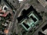
I believe the color is an error. Look at the city. The streets are glowing teal.
Well, I’ve seen these colors all over the globe (India in particular) and I think it’s over-exposure or some other photographic process, rather than local color at ground level – These are bright places to photograph and the exposure / contrast probably over-reacts to the conditions – I don’t thing there is purple dye running down all the roads…
The colors are not representative of the real colors in the scene. This is an artifact of the processing of the photo by Digital Globe (or whoever provided Google with the photos of this area). Its possible the photo was just processed improperly, or there is a problem with the data itself. But, these color problems occur all over the entire photo and the adjacent photo to this area.
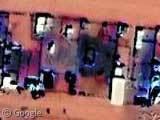
Not sure what the square/circle areas are. They do appear to be some sort of “compound”. There are a bunch of 18-wheeler-sized trucks in a row to the southeast.
Here’s more of the same color in India https://www.googlesightseeing.com/maps?p=&c=&t=k&hl=en&ll=28.804105,73.38275&z=18
Intriguing… I wonder what these skinny rectangles are to the southeast. https://www.googlesightseeing.com/maps?p=&c=&t=k&hl=en&ll=25.58822,47.169178&z=18 At first I thought some kind of pens for goats, but they appear vacant. Circle gets the square!
Well using flashearth.com I’ve found the name of the town to be Rumah in the “Riyadh” or possibly “Eastern” Province/Territory(?)
Haven’t had a chance to look into it any more than that yet.
Could be where they execute people. they are big on that in SA, and as far as i know it happens in an observational circle.
Rob you dont’ need permanent equipment for that.
The colors all seem odd all over that picture. Look at the streets also, they seem to be blue. It could have been an old military (US) base outside there…and the US burns all its stuff when we leave a place like that. Watch the movie Jarhead and those are the same kind of walls they used in their camp.
Those look like the kind of water troughs you would see in the middle of the desert Phillip
Did a quick search, didn’t come up with much of Rumah besides this link… http://the.honoluluadvertiser.com/2000/May/21/business13.html
Could it possibly be some kind of park or exhibition grounds for cerimonies and such? That’s what I thought when I first looked at it.
The town is Rumah. I suspect they are settling ponds for some sort of mineral extraction process. The same colour can be found around uranium mines in Australia (Olympic Dam, for example).
Could it be oil or something similar?
Looking at it, I would say that the central part is a firepit or central square.. It looks like the ruins of a trully huge compound.. Maybe the weekend getaway fo the orld’s richest man (outside of the USA)?? Al Saud??
I’ve never even been to this site before (and I’m finding it to be quite interesting), but I had to post here. You guys have like ten different theories going: – Dying Compound – Photographic Exposure Error – US Military Burn Site – Execution Compound – Giant Water Troughs – Ceremonial Grounds – Mineral Extraction Pond – Weekend Getaway
Personally I think it is the mineral extraction pond.
I dont know what they are but have flown over the ara and there are lots of them, and they do really exit.
Hmm, interesting.
I see it’s a newer rebuild of some older (ancient?) place. Just to the south of the large square you see the remains of a previous square, roughly quarter of the size of the new one. No center circle left though…
I see many, many tracks converging on the roundabout, and a long shadow cast by the pilar/statue/obelisk in the center of the roundabout. So that would explain all the tracks coming to there: it’s the highest thing in the surroundings for people to head to when travelling from afar, or else they all have the same brand of navigation units 😉
I see a few hundred meters to the south-east of the large square a parking lot with lots of freight trailers. Brothel?
I see traphic on the roads.
I see the town of Rumah. (which country is this anyway? Saudi Arabia?).
I see the whole thing is relatively in the middle of nowhere.
I would guess, that last is exactly the “raison d’etre” of it all: it’s a traditional oasis/watering place/gathering place/trading place which is precisely needed in the middle of nowhere. The older square would be the original owner’s/chief’s/clan’s conclave. The newer bigger square being the modern upgraded version, and the town of Rumah having arisen next to the squares over time.
The circle in the center of the new square is to me obviously for social, religious or recreational, purposes.
It remains for me to guess whether the original focus of these places has an aquatic, a religious, or an arbitrary reason. I would rule out mineral and certainly also military.
Cheers, Nick
Thanks for the quick sign up\post method, otherwis i would have kept my opinion to myself xD. i say missle silos! the squares with little evidence of a circle in the middle are silos that have no been opend in a long time, the missle ports are simply coverd in sand?
clearly this is the SA division of Burning Man…
https://www.googlesightseeing.com/maps?p=&c=&t=k&hl=en&ll=40.749013,-119.242666&z=16
This area out side the town of Rumah is famous for camel racing
Want to see more? There’s thousands of weird circles in Saudi Arabia.
View Placemark On high resolution regions, it really looks like some kind of sprinkler system for agriculture.
The circles you found in Saudia Arabia are for Central Pivot Irrigation.
http://en.wikipedia.org/wiki/Center_pivot_irrigation
OK. Looking into this, there are some seriously messed up places out there in the desert!
Houses/dwellings/buildings: probably a large, extended family built the small community, then abandoned it. All of the abandoned houses out there are stripped of materials, supposedly due to no trees anywhere?
I think the trucks that are lined up might be practice areas for suicide bombers? I thought SA was a little mellow in that regard, but the area seems to have been deserted for a while.
Looking around, I saw a lot of military bases with large airports and TONS of housing that is seemingly completely abandoned. I didn’t post a link (don’t know how), but you don’t have to look far.
Aren’t there some other satellite sources? I was at one the other day, but can’t remember what it was. An alternate shot might help.
OK. Im not taking back wat I said about all the strangeness in the desert i’ve seen as a result of this post. I am, however, posting the results of asking some African friends of mine about this site.
As soon as I showed the site to them, they said it is (not was) a large family grouping/compund. The colors are a screw-up that the entire photo pass suffers from.
In Saudi Arabia, when you get married you are allowed to ask for land, and the government has to give it to you. As you can see, there is plenty to go around.
Typically, the union of 2 families is quite large, and it is customary for them to all live together afterward. The site’s earlier rectangular areas are (they think) from earlier marriages i nthe family line, each one taking up larger amounts of land.
To keep things even (or to keep an eye on everyone else), the houses (yes, they are houses with yards) are not put in rows. All can see the others. The fact that a house lot is approximately a certain width, and there are so many, is what determined the dimensions of the square. The radial lines on the inside of the block are thought to emminate from the newlywed’s (most recently wed’s, really) house.
The circular area in the middle is a gathering, ceremonial area that is “not finished”. Over time it will be developed a bit more-this is the “official” word from my “unofficial” friends. I would assume that although the families have obvious relative wealth, they are not necessarily exceedingly modernized/westernized. The area being relatively spartan in nature by western standards is most liekly due to it’s being intentionally traditional (nothing but sand).
Strangely, when I asked if the area to the southeast was a truck stop, they looked at me with puzzlement, saying “There is no such thing in Saudi Arabia!”. It might be true, as there are no fuel distribution facilities (pumps), and the area the vehicles are in has no paved access-which would be expected of trucks with heavy loads being “customers”.
The tracks in the area mostly go “through” the places that the “trucks” are, with precious few tracks seeming to come to or from the vehicles. Looking at the site of each truck/trailer, you can see “yards” or sorts drawn out. I think these are mostly tractor trailers for housing. If you notice, there are no “cabs”, or vehicles to pull them. They aren’t there for storage/transfer, as there is nothing stored anywhere near them, nor signs of any vehicular traffic-save for the older tracks. With a lack of building materials, trailers would make ideal housing for those unable to afford more.
…just my $0.02
pat 🙂
Guys,
Took my Harley out there this morning and the colours on google are not what is going on out there. Could get too close to the area due no roads but ohter places close by don’t have those colours.
Snake,
Were the trailers setup along the road make-shift houses?
Thanks for any info, and the gas to go out there!
pat 🙂
After a bit of googling…I think this might be a camel market…The “roads”/paths are used more by camels than actual vehicles.. And the circle in square might be burial place/worship area… I also read that some of the sands have a high iron oxide content..Probably not enough to make them purple…But enough to make it look rather like mars…
Just my uninformed opinion 🙂 Take care all!!!
Mikki (#28)
Thanks for the info!
…Now if only we could get a shot of a camel market in progress!
TIme to “comb the desert” (Spaceballs pun intended) again!
pat 🙂
Looks like somebody finally collected enough ore for gap generators! Due to the splotches of similar color elsewhere, this is most likely a processing issue. Couple drops of the wrong stuff hits the film at any point in the process and it can do stuff like this.
Yes, have seen it too while flying over parts of SA. There many of these patterns on the ground in remote areas.