Telling the time on Google Earth
Wednesday, 22nd November 2006 by James Turnbull
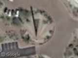
The KT Palmer Sundial is the largest in North America, described well at The Big Waste of Space. As sundials were primarily designed for telling the time it should be easy to find out when this satellite photograph was taken.
By my measurements the shadow of the sundial is at 337 degrees or 11 hours 14 minutes1. To translate this to the local time we must adjust for the sundial's location on the Earth by following the instructions in this article.
Arizona is Mountain Standard Time (MST), which is GMT - 7 so the centre longitude is 105 degrees West. The sundial is 111.9 degrees West, and we need to adjust by 4 minutes for every degree off centre. That means our sundial is 27 minutes and 36 seconds behind local clocks and watches.
Next, we have to adjust for the "Equation of Time", which means we need to know the exact day this photo was taken. As it's a Digital Globe picture, we can find it in the archive where they date the photo to March 12 2005. Looking up this table we need to subtract 9m and 42s2.
Sticking it all together I therefore conclude that this satellite picture was taken at 10:36:42 MST on March 12th 2005!
-
It is here where the most error is introduced, firstly because I measured the angle by holding an old protractor against my laptop screen. Secondly, we have to wrongly assume that the satellite was exactly overhead the sundial and completely stationary at the time of the photograph. ↩︎
-
And, here's even more error. Apparently these values are only for 12 noon and we'd have to interpolate for other times. Did someone say this would be easy? ↩︎


You tried your best =]
So it was anywhere between 4 in the morning and 11 at night. Eh, close enough.
I think the area of houses to the south is almost more interesting – who decided to do such a contrived street/park plan, and who designed all the weird-looking modernist houses?
https://www.googlesightseeing.com/maps?p=&c=&t=k&hl=en&ll=33.805031,-111.922939&z=18
@Birdseed
Those are all John McCain’s houses
One might extrapolate this calculation to any well in Alexandria (https://www.googlesightseeing.com/maps?p=&c=&t=k&hl=en&ll=31.191424,29.910944&z=18).
There is also one other piece of information to factor in: the Digital Globe record states the Nadir and Azimuth angles, to which one might also add the radial divergence from the centre of the photograph, although it would also be appropriate to add the difference of height from the same. That it is a Saturday is relatively evident from the empty carpark of the office block just to the north and the presence of the same in the shopping area opposite. One other approach needs good local knowledge (such as the presence of a bouncy castle in the garden next door to my own house in Brussels, making the white blob in the shade me weeding my garden: this is such a rare occurance I can place it to about 1000 on the day in question).
where do you sleep? do you sleep in space
James: All this not forgetting that Arizona doen’t go on daylight savings time, so from April to October one would also factor that in.
Birdseed.
I’m quite familiar with the place. Its an area of small commercial shops in Carefree, AZ, about 20 mi. or so NNE of Phoenix.
thank’s for this article jame’s I learned so many things because we will have a test about how earth’s tell time and I’m probabbly sure that I can answer the test tomorrow.