Mystery Plane Crash
Friday, 26th January 2007 by Alex Turnbull
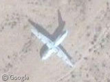
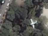
Deep in the Mojave desert, there's some sort of aircraft which looks as if it crashed and was left to rot. So how did it come to be here?
There's a military airfield to the east, Camp Wilson, so it's possible the aircraft came from there - but why would they just leave it in the middle of the desert?
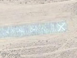
Of interest is that this location is very close to (that famed magnet of extra-terrestrial activity) Giant Rock. There's even more airstrips just south east of the crash site at Outlying Field Seagle, where two of the strips are abandoned but apparently the third is still in operation. Most interestingly, the Xs at each end of the runway indicates that no-one should try to land here, as it's used exclusively by unmanned aircraft...
Thanks to Shane McGillacutty.
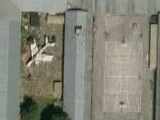

Nearby, just outside the charming looking town of Twentynine Palms, is a really big looking aspirin. That or some secret military installation of some sort.
https://www.googlesightseeing.com/maps?p=&c=&t=k&hl=en&ll=34.155337,-116.018178&z=17
Doesn’t really look like much of a crash. If so, not a recent one. No burn damage on the plane, the plane looks mostly in tact. Not even any crash marks on the ground behind it. That must be the smoothest crash ever had.
If it did crash, its probably because it lacks a horizontal stabilizer. 🙂
More likely it was dumped there and used for scrap.
Poor C-130… It’s odd to see it in the middle of nowhere like that, as opposed to a boneyard. Maybe some general’s kid wanted a desert alternative to a treehouse. =)
Alex I tend to agree, but why would somebody deliberately take it all the way out here? I mean, unless – as phillip says – this is a tree house.
Um, a tree-plane.
Without any trees.
😀
My suspicion is that it didn’t crash, but simply failed to take off from the dirt strip directly SE of it and skidded to a stop. (C-130s, after all, are supposed to be able to use some fairly bad runways.)
It seems odd, but if you’ll notice, (also use the ruler tool in google map), the plane’s position and the X’s on the runway line up exactly?
Also, if you connect the paths it makes an angle that looks like an arrow pointing to a north western direction…just a thought?
Umm… it did not take much Googling to determine that the C-130 airframe is likely used for combat training by the Marines stationed at TwentyNine Palms since it is located within the grounds of the base.
http://www.globalsecurity.org/military/facility/29palms.htm
“The Combat Center at Twentynine Palms occupies 932 square miles, or 596,000 acres of the southern Mojave Desert. The Combat Center is three-quarters the size of Rhode Island. Such a sizable land area is essential to the conduct of realistic air/ground combat training exercises.”
http://www.29palms.usmc.mil/
PeterG, what is this “Googling” thing of which you speak? 😉
Thanks for clearing that up 🙂 (however I reserve the right to continue discussing conspiracy theories regarding X shaped tree-planes acting as arrows towards UFO landing sites…)
😀
From a source in the know:
It is a USMC KC-130F, ex Davis-Monthan store. The unusual shadow of the tail is due to the rudder being removed. Used for assault training via helicopter borne Marines…
X’s on a runway mean that the runway is closed/abandoned and not maintained. A signal to pilots not to land on the runway (even UAVs shouldn’t try to land) as they might find their aircraft hitting a stray cow/cowboy/camel/UFO/marine or your garden variety Pothole.
🙂
The entire area looks like a live fire test/training area to me
Its used for training, I have been on it. There are several of these at 29 palms and NTC.
It did crash in the fall of 2001 on takeoff from the 29 Palms Expeditionary Airfield (EAF). Because of its location and damage to the aircraft, it was deemed unnecessary to remove the airframe.
I’m an air traffic controller that was working on the airfield in spring 2002 and the airframe is actually quite the eyesore from the expeditionary tower.
what are all the little abandoned shacks along the road from Amboy to Twentynine Palms. There are 100’s of them. Some have people living in them but most don’t?
Regarding the big aspirin near Twentynine Palms- it’s just a big water tank on a hill outside of town. It’s very visible from the road coming back from Amboy and Las Vegas. There are a lot of live-fire and assault exercises on the Air-Ground Training Center all the time- we hear artillery and bombing pretty often, and a lot of Marine aircraft shuttle between the expeditionary airfield and the helicopter fields at Camp Pendleton and MCAS Miramar.
The little abandoned shacks are the unimproved homestead shacks that were built by people in the 50’s, with the hope to be able to own the land if they continued to improve. These are the ones that didn’t.
It crashed on Feb 12, 2002 after loosing a few engines on take off.
So #15 Tom is the winner on this one.
Sorry it is NOT on a range and IS on the base.
Closer photos of this plane are here. http://woodser.com/photoshow/29_Palms_C-130_Crash/index.html
neet plane say tom would you at one time have been married to bonnie R???? do they use this plane for target practice????
The plane is a USMC KC-130F that crashed in Feb. of 2002. It lost its number-1 engine on takeoff from Twentynine Palms Airport to the southeast, then started to lose power to its number 4 engine as it tried to return. The pilot attempted to line it up with an old dirt runway nearby, but came up just a little short. He ended up having to land on some “unimproved desert.” Everyone pretty much walked away, but the old (about 40 years old as I recall) tanker was a write-off.
The first one is flying and the second one is not a airplane it is a x on the run way.
Those shacks ARE the improvements to the land that allowed homesteaders to purchase the land at very discounted prices. The minimum requirement for improvement was a 150sqft permanent structure. After this was built the homesteader could buy his 5 acre parcel for (I think) 50$
Lots of these shacks are still standing and some are in ok condition. Most of them were built in the 50s-60’s. I know, I have one. 🙂
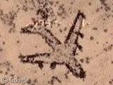
Someone thought this bit was ugly: https://www.googlesightseeing.com/maps?p=&c=&t=h&hl=en&ll=34.352657,-116.277232&z=18
Answer. KC-130F Crahed while I was assigned to 3rd MAW at camp Wilson, Support Co, Heavy Equipment Platoon. As I was a new “Journeyman” equipment operator it was up to me and another devil dog on a LRT 7 1/2 ton marine mobile crane to begin disassembly on the tail section. This was terrifying for me, as I have a fear of heights. Being in a “birdcage” at the horses head end of the boom 50 or so feet in the air with an impact wrench and a compressor scared the crap out of me. Luckily some civilian contractors were soon called to “help” us, and soon took over the process. Apparently, it was decided that it wasn’t worth the money or manhours to complete the project of pulling it all apart. And there is, or was at the time, a debris trail extending at least half a mile where the pilot belly landed with great skill and no serious injuries. Cool to see this online as I had totally forgotten about it. Corporal James, Joshua H USMC
Wow…my husband was the pilot of that plane. He never talks about it and has a roll of undeveloped film from the crash site. It give me chills just looking at this. Why did I google this, I really can’t say. Cpl James, thank you for giving him his props. Yes he is an excellent pilot.
It appears by the shadow that the plane is in the air.
Actually if you compare the maps, this is the exact location.
http://aviation-safety.net/database/record_map.php?id=20020211-0