Jamesburg Earth Station
Monday, 23rd April 2007 by Alex Turnbull
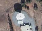
This is the 30-metre wide satellite dish of the Jamesburg Earth Station. Originally built in 1968 to support the Apollo 11 moon landing, the Earth Station was shut down in 2002 and put up for sale.
It was subsequently bought by a group of Ham-radio geeks, who spent several months restoring it - and in February they actually got it working, bouncing 20 radio signals off the moon.
There's a great ground-level shot at the official site, and it was Aviation Week that published the original story.
Thanks to jher via Boing Boing.


Highly imaginative road names leading up to the site and not a bad story but I was wondering what this is just to the north,
Google Maps Link
does it have anything to do with the dish or is it the skinniest runway in the world. Any ideas anyone?
Gosh, you guys are quick. I saw this story last night on /. and went looking for it myself. (Before, of course, I found the L/L on the dish’s website.)
PS The hams don’t own the dish, the owner has allowed the hams to make the dish viable again, probably hoping for either a partially profitable or attractive purpose.
I’m almost sorry that Keith gave us the true story because i had a great vision of the classified ad in the local paper
For Sale One Satellite Dish One careful owner 1968 model ‘classic’ – 30m high – White – VGC All sensible offers considered.
How much does a second hand Earth Station cost i wonder?
That thing Mrb found is interesting – at first i thought it may be a sort of scale model of the universe showing the distance between the planets (there is one at Jodrell Bank in the UK) but it doesnt seem so. There are “R”s at each end just to add to the mystery.
I think it’s a runway for a crop duster..or for RC planes? I dunno…
That runway/whatever thing is quite interesting.
I do think it is a runway, and it’s certainly not for RC planes. About 15 kilometers – sorry – kilometres NNE there is a real, typical RC field: https://www.googlesightseeing.com/maps?p=&c=&t=h&hl=en&ll=36.549966,-121.542982&z=18 Note the differences.
The runway Mrb found is about 850 meters – sorry – metres long, which is quite much for a small private airstrip. But I don’t think it has anything to do with the dish. It’s probably just somebody’s very own “airport”, possibly for a crop duster. Such a plane could be housed in one of the buildings to the east.
What perplexes me are the “R”-markings. “R” on a runway end usually means “Right”, e.g. “18R”, but this would require a “left” runway. Furthermore, there couldn’t be an “R” on both ends of the runway. It could mean “Restricted”, but this abbreviation wouldn’t be very common and I haven’t found it anywhere on the web, including the FAA’s website. If the runway was closed, they would have painted yellow “X”s on it.
I just did some research on the internet and didn’t find much information, but I came across “Rana Creek Ranch”, which is apparently located in that area. http://www.ranacreek.com/ I still don’t know if they have anything to do with the airstrip (although there seems to be some connection to it (as well as to the name “Markkula”). Maybe someone would consider e-mailing or phoning them and ask them about the airstrip.
Oh, here’s a PDF I found, but I couldn’t find out if it refers to this airstrip: http://www.co.monterey.ca.us/pbi/cca/cca2003/PC/02-26-03/PLN020166PC2.pdf
I guess I’m just too much into it.
Man, I’d love to have an antenna like that in my back yard
We are NOT Ham-geeks! Just Hams, thank you.
According to what information I could find about the letter markings on runways and from some of the strips I’ve seen around here, the letter R at the end of a runway designates the runway as restricted or not for public use, just as the letter X on a runway indicates that it has been closed and is not maintained.
At first I thought that since this was originally a government antenna facility, it might be configured like many other remotely located communications facilities, they often have a small airstrip located nearby, but that one is too far away to be practical since it’s over on the other side of a ridge and there is plenty of room nearby for helicopter landings.
I love the video on the web site showing them actually doing EME (earth-moon-earth) communication, it’s not something that’s very easy unless you have a really large antenna (30m should do nicely) that can be programed to track the moon
You can hear the operator doing a test call and hear it coming back as soon as he unkeys the radio. Kewl
Why with a field of that size the they would they make a runway that thin, it might be ok for taking off but what happens when you are coming into land? especially if there was a cross wind, I doubt you would hit it at all. It measures approx. 9m wide by 1/2 a mile long, if you find another airfield in the owrld which is proportionally similar I’d be interested in seeing it.
I emailed the fella at the Jamesburg Earth Station last night anyway, just to see if he had any idea. I will let you know if I get any response
I have it, a response that is from Pat at Jamesburg
Sweet!!
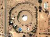
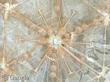
Talking about dishes…this has probably been post on GSS before but this is the worlds largest dish.
18.345442°, -66.751726°
Here are some ground shots. http://www.markerney.com/fun/arecibo.html
sorry…
View Placemark (18.345442,-66.751726)
Cool Dish, seen the above before. Maybe you should start a ‘dish’ month or something lol, I bet there are lots of cool dishes around the world.
Here are some pictures I took of the Jamesburg Earth Station when I operated the dish (moon bounce) in the Summer of 2007. I’ll be going back again this summer: http://picasaweb.google.com/jawayetti/JamesburgEarthStation