Fake City (US Secret Service Training Facility)
Wednesday, 25th July 2007 by Alex Turnbull
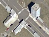
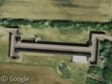
Like something out of Blazing Saddles, here's a completely fake city outside of Washington D.C.!
In fact zooming out to see the surrounding area, we can see there's all sorts of odd things here, including driving courses, underground bunkers, some sort of weird runway / skid track thing, and a helipad complete with helicopter beside what looks like, um.. the front of a rocket?
In actual fact this is the US Secret Service James J. Rowley Training Center which officially comprises around 500 acres of land, six miles of roadway and 31 buildings. Unofficially, it also has an obstacle course, simulated airport, firing range, and several outdoor training and tactical response areas.
The not-very-secret Secret Service website says the facility provides an environment:
that promotes critical thinking and innovation in the areas of physical, site and event security, threat assessments, antiterrorist intelligence techniques, emergency preparedness, criminal investigations, protection of critical financial infrastructure, and management development.
Strangley, on Google Maps there's nothing of this facility shown at all on the road map - and on our own map page (which uses the Google Maps API data), the facility is marked as an Agricultural Research Center!
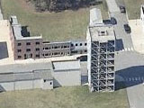
And yet despite the secrecy, you can get an ever closer look at the fake city with Live Map's Bird's Eye View.
Thanks to Rickard Jensen, kjfitz and ZedNaught.
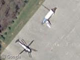
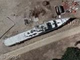
I think that “rocket” is most likely the nose of a plane for practicing protection while boarding/disembarking an aircraft.
But just how many black cars do they need? They’re everywhere!
The “rocket” is a mock up of airforce1. The helicopter is also a mock up of the helicopter used by the president.
That would be the James J. Rowley Training Center.
Not only a great find, but admittal that Live Map is a great prog..?
Here’s another one, near Sacramento. Not sure what the purpose is. I think it’s called “Safety City” or something like that.
View Placemark
Hopefully that link worked.
Matt
@Keith T. – hmm, I don’t think I made a typo did I?
@Ben – Hmmpf! If they could make in work in my bleeding browser I might be a be more accommodating…
Thing Rocket looking thing near the Helicopter is a Mockup of “Air Force One”. The helicopter is “Marine One”. These are used to train on getting the President to and from the White House for flights abroad. (secret)
Presumably just to the north of the tower block is the simulated grassy knoll?
There is a huge agriculture and wildlife research center right there, though it’s not marked on Google Maps. Here is the Patuxent Wildlife Research Center page. I’m not sure what the name of the agriculture research center is, but it’s there, too – hence the names of the streets in the area.
The training facility can’t be too secret – there’s a park right next to it…
This is also the exit that is marked “NSA”, so I am sure there is all kinds of secret stuff out there. I need a security clearance! That would be awesome.
I think the north end of the “fake city” is a simulated facade and driveway for the Whitehouse.
Blimey Peter – that is really realistic isnt it? They have even gone to the trouble of doing a mock up of the surrounding streets aswell. Amazing! ; )
anyone read andromeda strain? isn’t the alien research centre in a fake Agricultural Research Center?
There’s another Safety City in Calgary:
51.006552,-114.099798
I seem to recall one in Pinellas County, Florida from my youth as well.
Try again with the link for the Calgary Safety City:
http://maps.google.com/maps?ie=UTF8&oe=utf-8&q=safety+city&near=Calgary,+AB,+Canada&fb=1&cid=51008736,-114101034,14282253639407723485&li=lmd&z=14&iwloc=A&om=1
I live in Anne Arundel County, MD but I’m from Prince George’s County, MD – where this picture was taken. I’ve driven down Powder Mill Rd. plenty of times and they have a lot of signs that say “gov’t property” and “keep out” and whatnot. I had no idea that that was back there. Great find.
That area is about 20 mins outside of Washington, DC and about 40 mins from Baltimore. There is an actual (or assumed) agriculturual faciility around there as well as a farm.
Jack – Pinellas County? I’d be interested in knowing where. Maybe you’re thinking of Safety Villiage in the Lowry Park Zoo area, Hillsborough County.
View Placemark
Interesting find …
I hope Camp Peary will get high-resolution coverage soon: http://en.wikipedia.org/wiki/Camp_Peary
he will soon or later
That’s the Beltsville Agricultural Research Center (known as BARC). It’s just a few miles north of the University of Maryland, College Park. I’ve seen the signs saying US Government Property, but never could’ve expected this!
@Lee B.: I believe this is it: View Placemark
It shows up better in the Live Local Bird’s Eye view: http://local.live.com/default.aspx?v=2&cp=nnrhxy831rcm&style=o&lvl=2&tilt=-90&dir=0&alt=-1000&scene=11476442&encType=1
I live about 5 miles from there! My friend just started with the Secret Service and he is training there for the next few months…
The safety center is not in Pinellas County, Florida but very close. It is called “Safety Town” in neighboring Pasco County, to the north of Pinellas.