Two out of Three views of Japan
Friday, 7th March 2008 by James Turnbull
The "Three Views of Japan" are just like the Seven Wonders of the World, except they're all in Japan. And there's only three of them.
Firstly there's "Matsushima", a group of around 260 miniature islands which are all covered in Pine trees (or "matsu", hence the name). The area is apparently so beautiful that Matsuo Bashō (considered by many the grand master of the haiku) wrote the following:
Matsushima ah!
A-ah, Matsushima, ah!
Matsushima, ah!
Well, perhaps Matsuo Bashō was having an off-day, or maybe he too had only seen Google's current satellite image - because from up here Matsushima looks like, well, a bunch of tree covered islands.
Our second View is thankfully more exciting, the Torii at Itsukushima Shrine, which has been created in such a way that at high tide it appears to be floating on the surface of the water, and seen from ground level with Mount Misen in the background is a truly spectacular sight.
Not that we'd know of course, as this satellite shot sadly looks a little like a couple of sticks in a pond.
So, onto the final View of Japan! Well, we should be looking at a thin pine-covered sandbar called "Amanohashidate", except that it isn't actually on Google Earth yet...
Why bother seeing the world for real? Well, clearly these sights are better seen from the ground, but without the luxury of being able to go to Japan, we recommend that you check out this flickr gallery which really does contain some stunning images of all three of the famous Three Views of Japan.
Thanks to Stephanie and Dan W.
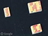

Anyone know what the rectangles out in the water past the torii are? There are a bunch of them and it looks like some have boats docked at them.
Boathouses.
If you’re into Japanese views with a Googley twist you might be interested in reading my site as I walk across Japan with my camera and GPS data logger. The map page will probably be the best one, when I start in three weeks.
Indeed the barely visible letters “E II R” on a forested hill somewhere in England is a much more spectacular sight…
Apologies in advance for the slightly long addition here, I have fond memories of my time in the Hiroshima area!
The rectangles in the water are oyster farms; the boats are collecting the days harvest. E.g., see the following;
http://www.lib.noaa.gov/japan/aquaculture/exchange/ustrip2000.html
The pictures really don’t do the Mijajima area justice in Google Earth! I would highly recommend it to anyone visiting the Hiroshima area. Just be prepared to be hounded by the local deer population that will literally steal food from the hands of unwary pass-by’s. Not to mention residents of the monkey colonies near the top of Mount Misen that will steal pretty much anything. The local English language signage is clearly written by someone with a sense of humour, whether it is the “8 minutes to the cable cars, or 6 if run a little”, the quaint “beware of the monkey” signs, or the simply badly spelt “free rockers” for storing your possessions to keep them safe from the marauding deer and monkeys;
http://realtravel.com/miyajima-reviews-a4452373.html
Rather more sinister in the area, 10 miles across the bay to the North East is the Hiroshima Prefecture Industrial Promotion Hall. This building was quite literally blown up in the atomic explosion of 1945 (hence it’s other name, the A-Bomb Dome). The ruined hulk has been left as a memorial to future generations as to the horrors of war…
View Placemark (34.3955,132.454)
http://www.richard-seaman.com/Travel/Japan/Hiroshima/AtomicDome/index.html