Weirdness on the Ocean Floor
Wednesday, 28th January 2009 by James Turnbull
There's some odd sightings on the ocean floor, thanks to the much-improved ocean surface depth images that were added to Google Earth and Maps last week!
Reader aliosha was browsing the atlantic and discovered a bizarre grid pattern in the deep.
About 150 km square, it presumably isn't a natural occurrence, but what else could create such a pattern it what must be extremely-deep water?
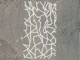
Even more bizarre, off the coast of Indonesia is what would easily be the largest writing on the planet. At around 130 km wide, it would dwarf second place by a factor of about 30x.
Unfortunately, it is only the largest writing on Google Earth, as this message doesn't actually exist.
It says "DTS/SIO", and was added by David T. Sandwell (DTS), a professor of geophysics at the Scripps Institution of Oceanography (SIO).
The sea bed imagery comes from a variety of bathymetry sources, including the SIO, and Mr Sandwell added the false underwater canyons so that they could see where the SIO's data was being used.
Thanks to aliosha and GEarth Blog (who also have news of a special event Google are hosting next week in relation to oceans on Google Earth).


Are you saying the grid pattern isnt real? If it is real then can i suggest perhaps some sort of fishing activity? These fishermen have all sorts of methods and i’m sure dragging their nets in a uniform grid may be one of them. Or its Atlantis. One of the two.
That grid pattern is far too vast and deep to be fishing related. There is also some variants on it slightly to the east near the Canary Islands. Very weird. I vote Atlantis.
Those are probably trawl marks associated with commercial fishing operations. But if that’s really deep water then I would say it is a data quality issue. It kind of looks like they had processing issues right along nadir when collecting single beam data. (those do look like sea mounts). If those scars are real and it is deep water then maybe it is something exotic like teleco buried lines or petro pipelines.?
“Reader aliosha was browsing the atlantic…” – some people do amazing things.
BTW, the first link (related to the atlantic browsing) only gives me a kmz file.
My vote is for the grid pattern just being a natural phenomenon. I compared the lines to the scale on the map and I’d say they’re about two miles wide. If you look off the west coast of Ireland you can see another huge grid pattern that’s about twice the size of Ireland.
only one comment… 90º angles do no mix with natural formations. it’s very unusual to find that king of angles in nature.
@dr.R: I’ve fixed that link, thanks.
I don’t know – given its position and proximity to Banda Aceh, I’m thinking that this may have been the cause of the tsunami back in ’05. See what happens when you mess with Google Earth????
What happened to “View in Google Earth” ?
Apparently the grid-pattern location was studied for disposal of radioactive waste, so I would guess that it has something to do with the information they gathered about the site. Here is a research report from ’87 http://eprints.soton.ac.uk/15118/01/250.PDF. the diagrams near the end show the location of the study site .
pooms, Are you talking about the square starting on page 68? Very strange. The lines off Ireland and equally freaky. Those too definitely look man-made.
Some guy over at the Google Earth Community picked up on the find of that giant DTS-SIO and located two more, both at the Equator: one in the Atlantic, the other in the Pacific Ocean.
http://bbs.keyhole.com/ubb/ubbthreads.php?ubb=showflat&Number=1194410#Post1194410
They look man made because they are simply man made artifacts of the data collection itself. You are looking at collections of images and data that has been stitched together and gridded to give a very rough sample of the surface. When put into a 3d visualization program like Google Earth it will add shading and colors to make it look as real and seamless as possible, but at this view can’t just wipe away artifacts from projection issues or tide zones or any number of data quality or processing issues that have caused the “man made” looking artifacts in that image. This data is probably collected long ago with lower resolution sonar and without modern techniques for tides.
If the lines were a result of a data issue, wouldn’t they be even more uniform? Even after reading the very interesting paper poops posted, I’m still not convinced that they’re man-made.
Not necessarily. The boundary of the collected data is dependent on motion of the vessel. If you’ve ever been on any kind of boat you know it doesn’t travel in a straight line.
That makes sense. I assumed that satellites were used for mapping the seafloor.
then, it seems to be just a mother nature’s joke 😉 “…The abyssal plain sediments consist of a sequence of thin to very thick structureless muds, sometimes underlain by thin, commonly laminated, silty muds interbedded with thin bioturbated marls and clays. The thin to very thick structureless muds were deposited by turbidity currents from three main sources: the flanks of the volcanic Canary Islands and, possibly,Madeira; the Northwest African continental slope; and seamounts and hills to the west of the plain). […] Over the last 300,000 yr, 600 km3 of turbidites, compared with 60 km3 of pelagic sediments, have been deposited on the plain…” from http://www-odp.tamu.edu/publications/157_SR/VOLUME/CHAP_28.PDF
aliens…
Something funky going on here as well: https://www.googlesightseeing.com/maps?p=&c=&t=k&hl=en&ll=74.531614,42.1875&z=5
What is the official largest type? The grid is kind of strange. Are there any people local to the nearest are that may have some knowledge?
The grid lines are most likely a processing artifact. Most of the ocean bathymetry data comes from satellite measurements of gravity. The gravity data are cross-checked against ship sonar tracks from a variety of vessels. The pattern you are seeing is typical for a research vessel surveying a patch of ocean floor. The gravity data and sonar data don’t always match up perfectly (the sonar data are many times more detailed than the gravity data) so you get these artifacts along the edges of the ship sonar.
I’m an oceanographer. I can tell you the grid pattern is simply the location where a ship has been to collect high-resolution data. In most places, the seafloor bathymetry is deduced from satellite measurement of the sea surface. It’s the “predicted bathymetry”, a good guess, but still, not as reliable as a direct measurement. In this case, some ship went there, collected bathymetry, but it seems that it didn’t agree exactly with predicted bathymetry, so the ship tracks appear as a grid. It shows how poorly know the seafloot really is! There are many other places where similar tracks are found (for example see a bit to the east). The tracks are particularly visible where the seafloor is sedimented and very smooth, like here. As for the irregularity, it’s a function of targeting study locations and minimizing the time (and cost) of the survey.
I think it’s bad to assume that all the lines on the topography data are a result of processing artifacts. While a great many of they may be, there are still a few that are actually being picked up on satellite imagery. For example, look at this site with Google Earth: http://www.satellitediscoveries.com/discoveries/land_sea_coast_structures/florida/florida.html If you look closely you can see the lines ARE being picked up on the topography and they ARE in the satellite image.
Also look at this anomaly: http://www.googleearthanomalies.com/Anomalies/tabid/56/articleType/ArticleView/articleId/31/Topographic-Anomalies-NC-Area.aspx More than a bit odd. Is it really there?
A ship track from a detailed sonar survey certainly seems plausible, though it does beg the question why anyone would do that on the featureless abyssal plain well away from the more interesting mid-Atlantic Ridge or the many seamounts and volcanic islands surrounding this region. In 1968 the US nuclear submarine ‘Scorpion’ sank in this part of the Atlantic with the loss of all hands. Might this be a sonar survey associated with attempts to locate the wreckage or even recover the wreck?
hey look – we’re famous! (NOT!) wow. Google should have been proactive on this for all of us (expert or not). Look how the wildfire burns:
http://www.informationweek.com/news/internet/google/showArticle.jhtml?articleID=214502197&cid=iwhome_art_Googl_mostpop
http://www.thesun.co.uk/sol/homepage/news/article2255989.ece
I stumbled upon this last year while exploring the ocean depths on Google Earth and have examined the pictures extensively. Its about 100 miles long by about 80 miles wide, and obviously not produced naturally. It cannot be marks left behind by fishing trawlers for the width of the channels or “grid line” is a mile or more wide and very deep. Furthermore the oceans are over fished, if these were marks left by fishing boats I am sure the entire ocean bottom would be scarred up by these same marks. Somebody mentioned waste dumping, that’s just stupid… why do you need to dig channels that are a mile or more wide and a hundred miles long to dump barrels of waste products. I don’t know what this is but its big and very interesting, being discovered by ordinary people exploring the ocean bottom on Google Earth. Plato did mention Atlantis was east of Gibraltar in the “real sea” Atlantic Ocean. And the land mass is gradually moving and sinking westward beneath the fault line that can be seen just west of this grid pattern. So due to this geological tectonic action we might expect this large grid formation to have been dry land at one point. That does cause a few problems with geologists, I think the rate at which the Africa land mass is moving is only a few inches a year. So at that rate we are dealing with hundreds of thousands of years back in time before this grid could have been exposed, and well before humans had the ability to construct even primitive cities… Erich von Daniken may very well want to propose an Alien city which may make sense if the human race was influenced or genetically influenced directly by Aliens …”Let us create man in our image”… William Bullerwell