GPeniS
Friday, 27th February 2009 by Alex Turnbull
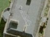
This is the very lovely, but otherwise totally normal-looking Place de Terreaux in Lyon, France. Nothing strange about it at all, right?
However if you turn on the "show labels" option on Google Maps, it looks a lot like Google have been trying to draw a gigantic GPS penis.
Is it possible that the map provider did this on purpose, as a way of identifying their map data (a Trap Street), or is this just a very happy-looking coincidence?
Thanks to Keir at Google Maps Mania.


It looks like there are 2 ramps going down, so this will be an underground parking
YEs, this is a underground parking ! http://www.location-parking.com/parking-public/69001-Lyon/Parking_Terreaux.htm
There may be something stranger yet about this, which makes this non-accidental – go ask some French esoteric specialists about the history of Lyon and the Place.
It is definitely a garage. Here you can see an entrance on Rue d’Algerie just east of its intersection with Rue Terme.
https://www.googlesightseeing.com/maps?p=&c=&t=h&hl=en&ll=45.767446,4.83212&z=19&layer=c&cbll=45.767542,4.83211&cbp=12,96.50602409638554,,0,23.072289156626503
The other entrance is on Rue Sainte-Mane des Terreaux just south of its intersection with Rue Sainte-Catherine.
https://www.googlesightseeing.com/maps?p=&c=&t=h&hl=en&ll=45.767667,4.832928&z=19&layer=c&cbll=45.768167,4.832694&cbp=12,174.45783132530124,,0,31.987951807228953
There are two other underground garages just east of this location that are also depicted, despite that you cannot see them in the aerial photography.
https://www.googlesightseeing.com/maps?p=&c=&t=h&hl=en&ll=45.768503,4.837208&z