Weird Waterways
Tuesday, 24th February 2009 by Ian Brown
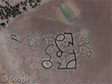
Today we have a trio of mysterious water-based sightings. First up, these strange pools in Arizona.
With all the other weirdness in Arizona, these symbols could only be alien communications, right? The reality is that they were created by Forest Service employees. While they were indeed thinking of how they looked from the air (do I see a face with a Picasso influence?), the intent was to improve water collection in this mostly dry pond known as Duck Lake.
Secondly, in central New Brunswick we find this network of varying zigzag lines:
I cannot come up with any explanation for this one. Aliens again? Some kind of scientific research?
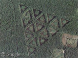
Lastly, a triangular network of ponds in Maryland:
Occult practices? Yet more aliens?
If you have explanations for the last two, do let us know. And of course if you know of weird waterways in your part of the world, we'd love to see them!
Thanks to Sean McCabe, Bully, Bob and Troy Stanley.
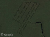

The second one looks like some sort of irrigation system, although the surrounding area doesn’t look much like farmland.
According to Wikimapia, the triangles were dug by a local farmer to clear the area for hunting, but he underestimated the water table and they became little ponds.
http://wikimapia.org/7955423/Dorchester-Triangles
That first image looks a lot more like Paul Klee than Picasso to me.
Little ponds? Those triangles have sides of over 100m!
Dug by a local farmer? Why so precise? I don’t buy it.
The first one seems to be art or silliness. Maybe someone wanted some ponds and got creative. Any 14-year-old can operate a backhoe.
The second one seems to simply be drainage like I’ve seen many times in swampy areas The zig-zag might be to slow down the water and minimize erosion and/or to break up the line-of-site for hunting waterfowl.
The third one is obviously aliens.
Phew, for a moment there, I thought you were going to say it was all perfectly explainable! 😀
…says the Forest Service. So it could still be alien communications, which the government is trying to cover up!
Aah, it must be so nice to believe in conspiracies…
Cummon’ use your imagination! Just off Chesapeake Bay, must be the storage silos for the missles off Red October…;@>
Googling the area – Decoursey Bridge Road – brings up a company in the area that does “game propagation” – raising game probably for hunting there are elsewhere. The triangles may be fenced areas to raise various game birds, a wild square in the didle for shelter and the cleared area around to see and eventually trap them for later release. There are also some scientific papers about “pen-raised” birds associated with the company. A complex area to the left, by the river, looks like some kind of rearing pens too. Up and right of the triangles, across the main road – Decoursey – is an interesting sort of runway with short winding roads alongside. I’ve no idea what that is.
very intresting
The New Brunswick photo is an image of cranberry bogs. They grow the berries and flood the region to harvest the berries.
Here is an article about the Triangles in MD.
http://articles.baltimoresun.com/1993-12-26/news/1993360081_1_wetlands-ellen-zeal/10
Here is an article about the Triangles in MD.http://articles.baltimoresun.com/1993-12-26/news/1993360081_1_wetlands-ellen-zeal/10