Saharan Stone Circle Mystery
Monday, 16th March 2009 by Alex Turnbull
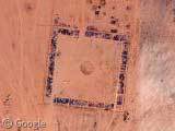
Right in the middle of the Sahara desert, in the dunes of northern Niger, there's a circle which is clearly not a natural formation.
The circle itself is roughly 52 metres across, but if we zoom out a little, we can see eight other markings which mark the sides and corners of a huge square area, about 620 metres on each side.
This French website claims that French soldiers created similar looking circles and markings elsewhere in the Sahara "at the beginning of the aviation era", although the reason why is unclear. Although the one in the article has no coverage yet National Geographic has a ground level photo of it.
However, very faintly visible above the circle are another set of markings, which might have once been a makeshift runway.
On closer examination, it seems that this particular circle has been "updated" since it was originally made. It's a little hard to make out, but in the centre of the circle is the word "FACHI", which it turns out, is the name of the nearest village.
See also the previously posted mysterious circle in a square in Saudi Arabia.
Thanks to Crash.


Looks like this was an old airfield which the circle would be explained not as a helicopter landing area, but what pilots would look at from altitude to determine wind. Inside the circle would be a large windsock or other wind indicating device. Here is the modern day equivalent. http://www.istockphoto.com/file_thumbview_approve/1331042/2/istockphoto_1331042-airport-wind-sock.jpg
There is also precedent for permanent markers being set up in the deserts for orientation of aircraft, which often relied on visual markers to confirm direction and location. I’ve read of these being used all the way up to World War 2 to assist aircraft with navigation.
okay, every single ime when i see the title in my rssreader, i think it’s something about Sharon Stone. what a disappointment… 🙁
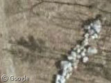
These stones indicates only the Fachi airstrip … sorry for the Mystery … This type of indication, with stones on the sand, visible for years, gave us the idea for the UT772 Memorial. See on June 15th 2009 on this website or on http://www.dc10-uta.org for details …
it seems to say ‘facki’ we have no idea what it means but i could of been made by the nazis
As I wrote before, it is wrtiiten FACHI, which is the name of the nearest village and it indicates the air stip…
it*
look closer it says FACKI
Weird, looking at lines of a similar nature, have you seen the markings a edwards air base, these have been there since the 1940’s, the were to give the pilots orientation when they left the runway i was talking with the guy at http://www.737throttle.com, he seemed to know all about it ,you can also see it on google earth.