AZF Explosion
Monday, 21st September 2009 by Alex Turnbull
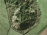
8 years ago today, on 21 September 2001, a huge explosion occurred in the AZF (AZote Fertilisant – nitrogen fertiliser) factory in Toulouse, France. Three hundred tonnes of ammonium nitrates blew up, creating a 200 m wide crater up to 30 m deep.
Steel girders were found 3 km away from the explosion, which itself was heard 80 km away (50 miles).
29 people died as a direct result of the incident, and over 10,000 people were injured – many thousands by the flying glass from the two thirds of the city's windows that were shattered. Around 40,000 people were also made homeless for several days.
The official enquiry stated that the ammonium nitrate had exploded following "improper handling", but there were unconfirmed rumours at the time that suggested that this tragedy was actually the result of a terrorist attack.
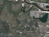
Just to the east of the crater is a large pixelated area. The Street View imagery isn't pixellated though, and shows gives a fairly clear view of a factory. I wonder what it is?
There's more information and theories available at Wikipedia.
Thanks to @KeirClarke.


The pixelated area is a factory that produces products for the French military among others, therefore it’s probably top-secret…
Not secret enough for MS though 🙂
http://www.bing.com/maps/default.aspx?v=2&FORM=LMLTCC&cp=43.564267~1.434946&style=h&lvl=18&tilt=-50.9026514088523&dir=75.1369713779252&alt=632.990239359438&cam=43.563442~1.43067&scene=-1&phx=-0.0740370185092546&phy=0.0688599846977812&phscl=1&where1=Toulouse%2C%20France&encType=1
The pixellated area corresponds to SNPE http://fr.wikipedia.org/wiki/SNPE (Société Nationale des poudres et explosifs = gunpowder and explosives). The logo is visible at the entrance when you take the smaller “chemin de la loge”. Most french army sites are requested to be blurred.
The “poudrerie” (SNPE, the pixellated area) was connected to the AZF site by a pipeline across the river:
https://www.googlesightseeing.com/maps?p=&c=&t=k&hl=en&ll=43.56453,1.432203&z=19
Supposedly the AZF site made phosgene (one of the gases used as chemical weapons in WW1), which was stored over the river in the SNPE. If that pipeline had been ruptured, things could have got very nasty.
This article is interesting: http://www.lrb.co.uk/v23/n21/seab01_.html
It’s even less blurred on the official french “we can’t let google do this alone” site: http://www.geoportail.fr/visu2D.do?cg=djoxLjEqYzptZXRyb3BvbGUqY3Y6MS4wKnZ2OjEuMSp4eToxLjQzNjQ2MzM2ODA1MjUzMTJ8NDMuNTY2NjQzMzM5MDg0MjEqczo2KnB2OjEuMCpwOmRlY291dmVydGUqbDpQaG90b3wxfDEwMHww
For a while, they didn’t blur secret stuff, but just removed it entirely, leaving holes visible from very far out zoom settings – which could then be looked up using google and (at the time) live.com That was fun.
Nevertheless, géoportail is actually quite cool, with the possibility to overlay multiple layers etc.
Seabright’s article is pretty flimsy. I find it hard to beleive anyone makes phosgene these days.
Why would you?
Parabellum – millions of tonnes of phosgene are produced every year worldwide (I found references on the web giving varying figures between 1m and 7m tonnes per year).
It’s a raw material for the manufacture of plastics (polyurethane and polycarbonate), as well as antibiotics and other products.
Certainly the SNPE site at Toulouse used a lot of phosgene – this article from 1998 says demand was increasing to 45,000 tonnes per year: http://www.icis.com/Articles/1998/01/19/52619/snpe-boosts-phosgene-unit.html
For pixelated area, see historical imagery (14 Apr 2002 imagery has no pixels) in Google Earth