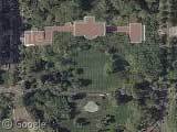
The Whitehouse
Thursday, 7th April 2005 by Alex Turnbull
Here's the Whitehouse, complete with 'national security protection' (some quick Photoshopping...)
About the author
Alex has decided that his title will be Senior Vice President of Stuff.
Not sponsored by or affiliated with Google
Thursday, 7th April 2005 by Alex Turnbull
Here's the Whitehouse, complete with 'national security protection' (some quick Photoshopping...)
Alex has decided that his title will be Senior Vice President of Stuff.

back up one notch and look. it almost looks like it is in a partial pentagram, and are those devil horns? hmmmmm. fitting depending on your political view. or maybe it’s just me seeing things.
A funny picture that is similar in theme can be seen in kokogiak’s flickr photostream. It made me laugh.
I think it’s a Masonic thing… there’s also a Maltese cross over to the right a little bit.
What’s really odd is that the capital to the right.. it’s blurred. What a shame we live in country thats so scared of everything.
Does anybody know what is this blurred out area NE from the White House?
View Placemark
That’s NW of the White House, not NE. I believe it’s the vice president’s residence.
Yup, that’s the Naval Observatory off Massachusetts Ave., where the VP’s residence is.
Wow… Blurring ‘sensitive’ areas out can really help a terrorist pinpoint his target.
They just don’t want you to be able to snipe the snipers that they have positioned on every-other roof in that whole town…
If you’d like to see what it looked like in 1988 (and in black and white with a big seam running down the middle), check this out:
http://terraserver.microsoft.com/image.aspx?T=1&S=10&Z=18&X=1604&Y=21550&W=3
Yeah.. masonic thing.. even the pentagram pointing at the whitehouse
http://maps.google.com/maps?q=1600+pennsylvania+ave.,washington+d.c.&ll=38.896140,-77.036444&spn=0.007939,0.007607&t=k&hl=en
and some other things
googling: pentagram washington should reveal some more
Heh, I’m mildly amused that various key locations in Washington DC are blurred out, but your friendly neighbors to the north have our Parliament Hill left in plain sight. Thanks guys, thanks… 🙂
Oddly, even though the Federal office bldg and its identical twin, the Treasury department bldg on the other side of the white house, have been crudely photoshopped over with olive-colored blockiness that don’t even accurately depict the shapes of the buildings, the deep wells/atriums of the buildings seem to have been given the lo-res treatment, since the details inside them are visibly choppier and blurrier than they should be.
For comparison, check out this pic of the white house which shows its roof, also shows the old Federal office bldg next door…. clearly, the rooftops shown in the satellite pics have no basis whatsoever in reality:
http://photos.nondot.org/2002-04-20-Washington-DC/2002-04-23/full/50%20-%20WM%20View%20of%20White%20House.jpg
I can’t understand what they have to hide by giving the low-res treatment to Observatory Circle, since it’s already well mapped anyway and has been for many, many years.
Interestingly, however, the Pentagon imagery seems not to have monkeyed around with.
For some reason, the Supreme Court building doesn’t get the same protection as the other two branches of government…
http://maps.google.com/maps?q=1st+And+E+Capital+St,Washington,+DC&spn=0.007467,0.008315&t=k&hl=en
The crude Photoshopping was not done in an effort to obscure potential terrorist targets, it’s been done to obscure various sensors and weapon systems on the roofs. Top Secret type stuff, ya know.
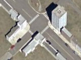
Also capitol seems to be blurred. I’ve looked closely and the all the buildings here seem to have been built following a certain geometric form. I can see alot of roads shaping triangles around the capitol. Check it
View Placemark
Well, the capol has been unblurred and the white house unphotoshopped on google Earth.
yeah, it does look blurred. but maybe that was the plane or satellite.
Pedro, All of the buildings that you see blurred out around the capitol are all SENATE and REP Offices. That is the Rayburn, and so on building, 2 are senate office and the others are for the house of rep…
In short, the capitol and the offices of the capitol are blurred out.
Just tu add that since Google Maps got an add’l level of zoom, all those sensitive buildings are in plain sight. For instance : View Placemark
The Gov’t must have finally understood the images were already easily available elsewhere on the net.
The images at Terraserver-usa.com are still photoshopped…It seems pretty pointless at this point since they are openly available at Google and other places on the net.
Anyway, why can’t I see the OUTSIDE of the Whitehouse, but the Whitehouse can see INSIDE my private phone records?
Can somebody explain clearly how you know the picture has been photoshopped? and what precisely has been altered? thank you