Planes In Flight Mega-Post
Wednesday, 13th April 2005 by Alex Turnbull
Please note that some or all of the objects mentioned in this post are no longer visible on Google Earth or Google Maps.
Well it's my own fault really. Since I posted that I hadn't seen any planes in flight, we have been absolutely inundated with submissions proving that I was completely wrong. Glad to hear it, 'cos some of these are really cool.
- Ryan (Cool shadow - look about 4 plane widths west)
- nowak (Can you find the shadow? I think its all the way over here)
- Arvo Huru (Anyone know what kind of plane that is?)
- Eric Thelin
- Brian Lalor
- Miker
- Chris (Pink plane. You sure its not parked though? I can't see a shadow anywhere!)
- Matt (From the comments - Three at once! Very cool but is it really three planes, or just one?)
- Geoff Sulcer (Tiny little one)
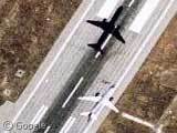
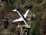
- Jason (This is the one in our first picture)
- Colin (This one is huge! Or perhaps just very high up...)
- Tobic (Another three planes?! One just off the top and another just off the bottom)
- Kent (Kent says this is a U2 spyplane!)
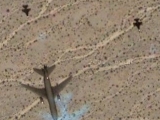
- josh k (Quite a few of the planes have this weird blue 'ghost' in addition to their shadows, perhaps its due to their speed...)
- caknuck (...or perhaps its a reflection?)
- Arvo Huru (Now that's fast!)
- Stilt (Apparently this is over Graceland)
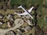
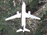
- Rod Levin (This is the one in our second picture)
- Tom (This is cool, its a razor sharp image. Can't find the shadow though.)
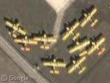
- DDA (And finally... toy-town planes!)
Couple of extra plane related ones, first from punk floyd, who says that this is a SR-71 Blackbird Reconnaissance plane parked on Beale AFB, and also from Allen Ormond, who fittingly points us towards the Wright Brothers National Memorial in Kitty Hawk, North Carolina. This is where the Wright Brothers made the first powered airplane flight.
Many thanks to everyone who submitted links but didn't get a mention, there were just far too many of you!
Here’s an airliner flying near Reklaw, TX:
View Placemark
This is the only plane on approach to Houston Hobby that I can find. It is obviously a Southwest B737 on about a 3 mile final for 12R at ~1500′ View Placemark
I’ve just found this page and found it very cool. This is a plane I found. It is about to land in Orly airport, in the south of Paris, France.
View Placemark
Caught this one over Paris, France with an odd blue shadow.
The plane found by Stilt is on the ground, not flying. Near the left wing stands smaller plane – military fighter, I suppose. Check this place in Google Earth for better view.
And the machines found by Ryan and Miker are the same plane – there are few more images of it nearby.
If you follow to this news story you will see the only flying lancaster bomber left in the UK in flight. http://www.theregister.co.uk/2006/01/09/google_lancaster/
the coolest plane and also the most unlikely plane to see..
Fabulous.
A military earplane flying over Bakersfield, CA, casting a fuzzy blue shadow.
Here is a plane (I don’t know what kind) flying over a residential area near the University of Minnesota in Minneapolis: View Placemark
Here is one I found today, not sure if it’s been seen before. It’s over Stanley Draper Lake in Oklahoma.
View Placemark
[quote]54. Ben Says: April 27th, 2005 at 11:59 pm Another nice one is Barksdale AFB in Shreveport, LA – B52s everywhere, plus some A-10s, and what looks like a group of US bombers of the past. [/quote]
Check http://www.8afmuseum.net/ for an overview of which bomber of the past is which. It seems a SR-71 has arrived as well (not on the maps yet though).
Re the SR-21 at Burbank, go north over the hangar ant there on the apron is something with a massive wing and little else. What is it ?
I found the shadow for the “pink plane”. It’s near the zig zag building to the west and a tad north along Southfield Fwy. I didn’t read all the posts so I hope this wasn’t a repeat post. =)
B-737 on finals over Bangalore, India View Placemark
i want a picture from HORABAD of iran
A plane over San Diego – very clear:
View Placemark
I think the “blue shadow” phenomenon is an artifact of image processing. All the images I looked at with blue shadows appear to have been Color Infrared images. CIR is routinely flown by agencies that need to do vegetation surveys, since it is easier to tell different kinds of vegetation apart in CIR than in “true color” or “natural color.” In CIR images, vegetation shows as red. It looks like the CIR images have been processed to make them more natural, and that probably shifted the shadow into the blue.
This leads me to a common misconception about Google Maps/Google Earth imagery. It is NOT all from satellites. The best imagery (i.e., the really high-resolution stuff, with 1 ft or even 6″ pixels) is shot by relatively low-level aircraft. Notice that the best imagery is typically over cities, out in the middle of nowhere the imagery is low-res. That’s where you’ll find either national 1 meter resloution photos done by high-altitude aircraft for the US Geological Survey, or actual satellite imagery from a variety of sources (e.g., Digitalglobe Quickbird, 0.6 m; Geoeye IKONOS, 1 m). When you use Google Earth to see places outside the US that have no equivalent to the USGS, the best available imagery might be Landsat (15 m) satellite imagery.
So, when you see multiple versions of the same aircraft in Google Maps (e.g., 3 images of the same airplane on a runway), that’s because the aircraft (not satellite!) taking the photos was flying on a line roughly in the same direction as the plane taking off, ensuring that the plane lifting off was captured in several subsequent photos. When the photos are mosaiced together, the plane appears in several different places, giving the appearance of multiple planes on the same runway.
Lancaster bomber over England
View Placemark
They should really come up with new planes and they should start to make jet packs
Here’s a new one in Madrid-Spain.
https://www.googlesightseeing.com/maps?p=&c=&t=k&hl=en&ll=40.583567,-3.564548&z=16
Heres a C-130 over the southeastern part of lake mead View Placemark
View Placemark
I was looking for my house and I found this plane with a loooong contrail at View Placemark (36.0057,-79.9585) in High Point, North Carolina. Just type Tangle Lane, High Point, NC and you can see it! View Placemark (36.0057,-79.9585) http://maps.google.com/maps?hl=en&tab=wl&q=
Small aircraft above Parker CO. There is a civil airport about 3 miles NW of this location.
View Placemark
ATR-72 plane approaching Quebec City Jean-Lesage Airport with that weird ghost in front of it.
View Placemark
What about half a plane, does that count? (The shadow is complete). It’s landing at Schiphol airport, Amsterdam.
Google maps
Awesome.
there’s also one near Ikea in Richmond BC, over the big intersection nearbye
I found a jet while looking over some hunting ground. It isn’t far from the house of an uncle and aunt.
Link:
http://maps.google.com/maps?q=6635%20Baux%20Mountain%20Rd%2CGermanton%2C%20NC%2027019%20(Tony%20Crews%20–%20home)
A jet flying over some family land I hunt on.
Sorry for being stupid and not figuring the out the first time. But the jet is about a 1/4 mile South Southeast east.
Plane over newport beach, ca. Just zoom in. http://maps.google.com/maps?q=221+a+st.,+newport+beach,+ca
View Placemark (46.962993,8.291609)
Found it just today.
airliner in flight over residential McHnery county, IL
http://maps.google.com/maps?client=opera&rls=en&q=il+60156&sourceid=opera&oe=utf-8&um=1&ie=UTF-8&split=0&ei=Q7_lSfzgGcTI-AarzYWBCQ&sa=X&oi=geocode_result&ct=image&resnum=1
above should be at Randall/Village Road
Another Scooby-Doo-Where-Are-You? ghost plane. Probably been spotted before but cant be bothered to trawl through 134 responses to check!
Near Hong Kong airport
View Placemark
Here’s a good one.
Looks like either a 737 or a A-319, can’t tell, flying over residential Hayward, CA
View Placemark
hi there is one from naples in italy View Placemark
Another one right over the beach (Huntington Beach CA)
View Placemark
The same plane photographed multiple times.
here’s one of them; try looking east and west for the other times when it was “seen”:
View Placemark
Found one over a small island south of HK
View Placemark (22.104031,114.030812)
I Found this one near to FL…
View Placemark