Trippy Triangle
Wednesday, 13th April 2005 by
More strangeness scratched into the earth this trippy triangle thing in the desert north of Vegas.
Not sponsored by or affiliated with Google
Wednesday, 13th April 2005 by
More strangeness scratched into the earth this trippy triangle thing in the desert north of Vegas.
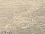
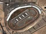
It’s a target, as indicated on the topographic map. Zoom out on the topo map, and you’ll see Nellis Air Force base nearby. My guess: this triangle and its inscribed circles are a bombing target.
And if you scroll up (north-northeast) from the triangle, you’ll see what looks like a military airfield and some other facilities. From what I can see, that airfield is not marked on the Terraserver topo maps at all. It’s all part of Nellis Air Force Range.
I saw this (or something just like it) from a plane over Nevada on a flight and I thought I was crazy…glad to see I’m not…
Is this another one? View Placemark
Not to become the official TopoZone fanatic, the but topos can help you find a lot more (smaller) marked targets in the area, like these two small targets due southwest of the triangle, on a bluff:
View Placemark
Looks to me like they were successful.
As for the airstrip to the NNE, it’s sort of there: http://www.topozone.com/map.asp?lat=37.795372&lon=-116.774025&datum=nad83&u=5
Due east of this location is Area 51, mysteriously omitted from Google Maps and shot at a much lower resolution. (Gee, I wonder why.)
I may be wrong, but this appears to be S-4. A smaller site associated with the facility at groom lake.
Due east of the trippy-triangle thingy there is what looks like some letters in the mountains. 2 “H”s are clearly discernable and ghosts of other letters. Maybe just natural formations but interesting all the same.
I found these posts because a friend had sent me an entirely diferent trinagle with circles than the one above:
View Placemark
Also in the test range. And I still wanna know, a target for what? If it’s for bombs, they need to practice more, ‘cuz they’re missing. Weird!
Spaceman’s triangle also seems to have a “3” in the top of it, or an “8” maybe.. if you look at the same place on the first triangle posted (the trippy triangle one) i see an eroded “2” .. bonus points to whoever finds #1….
My previous post was the wrong link. This one is to a star shape south of the targets
View Placemark
Endroits intéressants à visiter
Voici quelques endroits intéressants à visiter avec Google Maps! Le Serpent Blanc de Baja (à droite)
Neverland Ranch La Statue de la Liberté Cible militaire…
thats pretty wicked, why is area 51 so special, (i live in Canada) i know that the government does “secret” things with the airforce, but whats the whole thing about aliens?!?! emal me with the answers, thanks alot, have a good one,…[email protected](if you give me info, ill send you a gmail account invite)
regarding the trippy triangle: Theres no doubt in my mind that this is a target of some kind. other posts aroud military bases yielded similar shapes that did get hit. And that star thing is clearly some bored wicka in the desert trying to start their own burning man thing. But what i find a little weird about TrippyTriangle3 is that you can’t see any roads leading up to. To inscribe that into the ground, and have it stay for this long would probably require some heavy equipment. And on the other targets, the roads are plain as day. Maybe i just can’t see it.
here’s a crosshair near the same location View Placemark
Where are the Hs? I can not find them…
If you look around the same area as the targets, there is this array or “roads”, but if you zoom into the highlest level, there’s a plane in the middle of the desert
View Placemark
hi, well it’s probably thats the triangles are bombs target, but if you look the star you will see that the corner with the inverted “E” point to one of the triangles (wich one have a “E” inverted ponting north…are really targets?..all arund the A51, and bases, and some censured bases…it’s something weird ….i try to find tragets like that in other places..but i don*t find anyone..by the way..did you find the nuclear silo in this area?…
Ry, the plane in the “road is supposed to be there. In the nevada desert, each of these odd marking are part of an airplane testing program. Due to the secret nature of these tests, runways are painted the color of the background, in this case desert, and the planes are camoflauged as well. There is another area, View Placemark where if u look at one of the airstrips you can see another plane. You may say that enemies using this software can see the test planes, but they have more developed satellites than google eath that can detect infrared and heat, so they might as well be seen anyway. also, if enemies are looking for things such as this, they will be quickly scaning, at a much higher altitude with satellites, and will not detect the presence of an airplane.
Evan, just to the north of their you will find yet another target zone though this one looks like it has been touched. View Placemark
The “Trippy Triangle” pictured and surrounding area is within the Nellis Complex (area 51, Yucca Flats, etc)
Some people have been presenting misinformation here and claiming that airfields are “Nellis AFB” Nellis AFB is just outside of Las Vegas and these places are nowhere near Nellis. The airfield to the north is the Tonopah Test Range where the DOE tests all sorts of weapons.
This whole area around the “Trippy Triangle” is all apart of the some 625 square miles allocated to the Tonopah Test Range. You can see roads and targets and small black specs that appear to be machinery or artillery all around here.
To read more on the Tonopah Test Range please go here: http://www.serve.com/mahood/nellis/ttr/ttrmain.htm
In response to Evan’s comments made on Sept 10th 2005:
That airfield is a test airfield used for target practice. Those runways are non functional for anything heavier than a single engine prop aircraft (Cessna, Piper, etc)
The US Gov’t is really good at hiding runways if you look at Area 51 in the Groom Lake Lakebed you’ll see extremely camouflaged runways. There are 4 total in the groom lake lakebed at Area 51.
I noticed that the triangle is directly north of runway 30L at area 51. If you follow 30R you will see it it Tonopah. If you follow the runways in the lake bed. All fly direct routes out of the country passing over no major cities or towns. Maybe for supersonic testing. It looks like easy access to the Pacific. The weird circle farms all over look very weird too. They seem to grow in number and have shapes that don’t deem random. It all looks like it could be all a marking system, but who knows. We do know that Area 51 is real and shows up in high quality on a simple google earth search.
look around this area.. and you find some very weird thing… just up a but
here you see giant black block, with several strange coloured objets inside https://www.googlesightseeing.com/maps?p=&c=&t=k&hl=en&ll=37.871508,-116.788541&z=18
and these bizarre radar looking objects https://www.googlesightseeing.com/maps?p=&c=&t=k&hl=en&ll=37.918946,-116.778488&z=15
The “bizarre radar looking objects” you see are Irrigation guns. you have a military bace and need food… shipping food from las vegas is too expencive and you cant just hire a local truck driver…so you stick a big water cannon in the ground that rotates 360 deg. and you plant ALOT of seeds… after a wile you get one big circle of living crops. you may be asking your self why so many…. 1. less transportation of food to base, you dont need to go all the way across the range to get a head of cabbage or some corn(which costs alot of gas money 2. (my other thought) to also help pilots know where they are in the range without any fancy electronics.
I might have come across something here…
If there are three triangles numbered 1 2 and 3 If they are for calibrating satellites they would be placed directly in a equlateral triangle formation
I tried up and did not find anything instant (Quick Glance) I tried down and found something you should look at
not in good resolution but the shapes are pretty clear
It is..no They are what I think are missle silos now Im from CANADA and I never saw a real silo but these are what I think are silos if I ever saw any.
heres the pic https://www.googlesightseeing.com/maps?p=&c=&t=k&hl=en&ll=37.251237,-116.473446&z=13
could be this the missle silo??
View Placemark
at least it seems as a full underground construction.
WOW
This is about the 50+ nukes i have discovered
I went to google earth and clicked on Google Earth Community untill it turned into a checkmark
Lots of people have found alot of -BEEPING- nukes and the killoton ammount CHECK IT OUT NOW!!! You will thank me latter
JP…there is a nuke above the place you are looking at. Around the square with a circle looking hill. Nuke strength is .2 kilotons and is named RAY
Also I realized that I need to correct my previous entry
in Google earth… 1. Turn every thing off (no checkmark/dot) 2. go to Google earth Community 3. go to Google Earth Community forums 4. check MILITARY
from JPs map area, fly around north west to find large nukes (1 megaton) and to right where there are blast marks are some smaller nukes p.s. turn on earthquakes
north west big nukes View Placemark
east small nukes among previous undergroung nuke testing facilitys View Placemark
The Tally of all ovious ground etched the targets (circles, crosshairs, and triangles)
2 triangles numbered 2, 3 (#3 abandoned) 5 circles unnumbered crosshairs one numbered 7
this is my tally and still working on it
I think most of these are “Photo Resolution Targets” for testing the resolution of Spy Satellite, which is why they look so old.
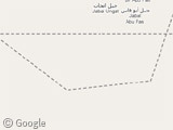
Here’s the “trippy triangle” is Target #5216T on the Topo Map at 37.6281°N, 116.8486°W
http://www.topozone.com/map.asp?lat=37.62758&lon=-116.84806&s=48&size=l&u=5&datum=nad83&layer=DRG25
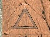
NEW IMMAGERY Number “2” triangle has been hit In other words… number “2” is a bombing target and i still believe that number”3″ is “Abandoned”. 3 has one or two odd looking shrubs that could actually be small craters
Any comments about these targets and others? contact me at [email protected]
hey im interested in area 51 link some stuff about it or about aliens that r interesting. please thankyou
http://bbs.keyhole.com/ubb/showthreaded.php?Number=1022942 this link goes to my Google Earth Community topic on all of the targets in the Nellis Airforce Range and the Tonopath Test Range
To anybody who was asking about the numbers/letters noticed around the trippy triangle- those characters say “2007 google”. You find them everywhere on google earth. If that’s what you were referring to, I definitely doubt they have any sort of significance.
I noticed a similar triangle out in Arizona.
View Placemark
It’s not close to any air force base (Luke AFB is over 25 miles away.) It’s actually pretty close to residential houses, so it’s definitely NOT an air force bombing target.
If you zoom out, you see that it’s right on the edge of the major cluster of civilization in the middle of Arizona. It almost looks as though this city was being “labeled” from the sky.
That gave me the idea to start looking around cities with lots of UFO sightings. (google search “phoenix lights” if you haven’t heard)
So I checked out Roswell, NM and guess what I found?
View Placemark
ANOTHER triangle! Perfect in dimensions, pointing exactly north, right on the edge of a city with many UFO sightings.
Notice how all three of these triangles are slightly different, but all have the same dimensions and they all point perfectly north. The Arizona one is just a solid triangle. The Roswell one has longer points. And the Nellis AFB triangle has circles inside it.
I can’t see any other explanation for these triangles other than someone wants to label these cities from the sky. Maybe the air force, maybe something else. Who knows???
Those triangle shapes are actually old airforce locations… with a traingle configuration no matter which way the wind blows (or how strong) you can have a runway that you can takeoff from. In times of war that is/was an important consideration for protecting the area.
its near the military proving grounds for Edwards AFB. they do alot of ground testing with artilery such as the NLSC 1000 self-propelled artilery as well as more accurate field gun testing and stabilizing rounds. Also it is around this area that the B-1B’s tested their new equipment such as the “sniper pod” laser designator and newer free fall munitions. Look up “yuma proving grounds” and you willl see similar targets.
Arent these marks on the actual map itself to calibrate it? As in if this is one of the scanned images, or its a marker they use for GIS operations and is not actually there?
http://www.defensetech.org/archives/001511.html
There is also another smaller circle near the triangle, a little bit to the north east. 37°45’19.58″N 116°31’41.37″W