Castro Street Fair, SF
Friday, 15th April 2005 by James Turnbull
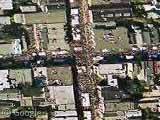
Castro Street is a street in San Francisco, California. Between Market Street and about 20th Street, it is at the heart of that city's gay village. When this shot was taken the Castro Street fair was on - you can make out the white tents in the middle of the streets and the sea of colour around them are the hundreds of people.

Fun with Google Maps
OOPS! Union Square Filled! View Placemark
Google Maps Satellite Image of Castro Street Fair?
…
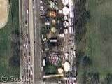
Can anybody find any other large gatherings of people? I was trying to find the Burning Man site, but the resolution in that area of Nevada isn’t good enough.
Good idea Wayne: View Placemark
Beyond Belief!
The Playa! Cool!
I was really surprised to find the photo was of the Castro Street Fair when I went looking for my house a few weeks ago (Noe & 15th, one block from the fair). As for Black Rock City, a friend in the Organization was able to pin the date that photo was taken as either Sunday August 20, 2003 or Monday August 21, 2003 after being able to spot that her dome was already set up and the state of the Cafe construction.
What a coincidence! These usually do not happen by itself. Here is the San Francisco Virtual Tour
I’d noticed the Street Fair, but I’m not sure about the date — because if you move northeast a few blocks, you’ll see that the central freeway is still up. Despite the fact that I live mere blocks away, I can’t quite remember when they took it down. Was it before or after the suggested 2003 Fair date?
Also curious is that the path of the long-gone Gough branch of the Central is still visible, ghosted by less development.
I think it was in the spring of 2003 when it came down. I moved from Gough & Market to the Castro in June of 2003 and it had just been taken down. Maybe 2002? The “new building in Golden Gate Park”:View Placemark is a big whole in the ground.