The Manicouagan Impact Crater
Sunday, 24th April 2005 by Alex Turnbull
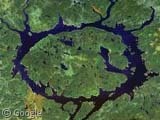
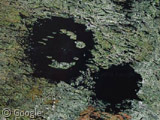
Wow. The Manicouagan impact crater is huge. Apparently it's one of the largest impact craters still preserved on the surface of the Earth, and was formed during a tremendous impact about 200 million years ago. The annular lake that shows the perimeter is 70 kilometers (43 miles) in diameter. Solarviews.com says:
Although the original rim has been removed, the distribution of shock metamorphic effects and morphological comparisons with other impact structures indicates an original rim diameter of approximately 100 kilometers (62 miles).
Thanks to Mike Scher, Philippe, Keith, Stuart Reid, Andy M, Markus and many others.
About the author
Alex has decided that his title will be Senior Vice President of Stuff.
The Manicouagan lake is now a reservoir for one of Quebec’s largest hydro-electricity complexes. Follow the river that leads south from the lake. The Manic-5 hydro generating station (http://www.hydroquebec.com/generation/hydroelectric/manicouagan/manic_5/) is located there. You can easily make out the main dam as well as its main gothic arch. Further downriver, you will find its smaller brothers: Manic-3 (View Placemark), Manic-2 (View Placemark), and Manic-1 (View Placemark).
No, I don’t know what happened to Manic-4. I guess it was planned but never built.
It’s also fun to know that nobody noticed the http://miac.uqac.ca/MIAC/crat-fr.htm before they build the http://maps.google.com/maps?ll=50.646629,-68.726006&spn=0.066433,0.085316&t=k&hl=en with multiple vaults of the world. http://www.hydroquebec.com/generation/hydroelectric/manicouagan/
Sorry, some of my text didn’t show, here it is…
It’s also fun to know that nobody noticed the crater before they build the biggest dam with multiple vaults of the world. More info.
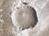
Just to the North West you can find the Clearwater West twin impact craters which are about half the size of the Manicouagan impact crater.
It’ll be just like any other day. A fireball will come flying down from the sky and plunge into the earth, bringing up dust and hot magma that will block the sun and create a huge tsunami that willl destroy all towns near the ocean, worldwide. The entire area hit will be on fire.
Here’s proof that it has to happen.
Sorry. The first link in my last post was wrong. The post should have been as follows. Just to the North West you can find the Clearwater West twin impact craters which are about half the size of the Manicouagan impact crater.
Wow — huge is right. You can still pick out the crater even when zoomed all the way out on the scale!
Wow, I actually was looking at this last night on Google Maps quite independent of this post. This area has always intrigued me on maps; I didn’t realize that it was an impact crater!
You can follow “the road” from Baie Comeau up to Manic 5, 219km paved. You’ll notice it then goes below the dam and up its right side. The road them goes for another 200 km of dirt road to a ghost mining town of Gagnon. Divided streets and sidewalks but no buildings left at all (after being there for 30 yrs.). Another 75 km of paved road and you hit the old Fire Lake mine (see if you can see all the fire damage along the way). It’s a twisty, narrow road from there for 60 km (takes about 2 hrs. to drive!) to Mount Wright, where Quebec Cartier Mining has an iron ore mine. About 20 km from there is the Labrador border and further North you can then see the other two iron ore mines (Wabush Mines and Iron Ore Company of Canada). Nice drive back and forth to vacation, eh?
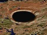
While on the subject of craters in nothern Quebec, we can mention the New Quebec crater (formely known as Chubb crater) View Placemark which is not as big as the Manicouagan, but is remarkable for its near-perfect geometry. Given its location however, I doubt many people have visited this place. There’s a ground-level picture at http://www.unites.uqam.ca/tuvaaluk/milieu_physique/FrCratNQ2.html
Crater-hunters should visit the Earth Impact Database http://www.unb.ca/passc/ImpactDatabase/NAmerica.html#
Manic is the biggest meteor impact in Quebec. At least recognized by scientists. The impact, 214 miliionsyears ago, provoked an extinction, the one that set place for the reptiles and dinosaures. The impact was such, that ejected lava was found in Great-Britain!
Many elements tend to prove that the Hudson bay could also be a meteor impact crater.
View Placemark
The islands have a different age and soil type than the coast and look at the nice circular curve (231km in diameter). Scientist hesitate to class it as such, because of the size of the meteor that it would take to do such a hole (30km in diameter). Some think it was smaller at the time, but expanded because of succesive earthquakes. But anyway, that would have been a real big impact…
oups, wrong link: View Placemark
My wife and I kayaked the whole Manicouagan Reservoir circuit during three weeks in August 2006. See http://www.astro.uu.nl/~rutten/Manicouagan_2006.html for extensive trip report and our photographs. We navigated on Google Maps prints – excellent! They showed much more reliably than the topographic map where to land and camp.
Doesn’t this look a bit like Strong Sad’s face (www.homestarrunner.com)?