Ford Proving Grounds, Dearborn
Tuesday, 26th April 2005 by James Turnbull
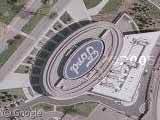
Giant Ford logo at the Ford Proving Grounds, Dearborn. A little to the east is what appears to be a large black vehicle driving around the track.
Thanks: Rick
Not sponsored by or affiliated with Google
Tuesday, 26th April 2005 by James Turnbull
Giant Ford logo at the Ford Proving Grounds, Dearborn. A little to the east is what appears to be a large black vehicle driving around the track.
Thanks: Rick
Just north of there
That’s a lot of parking!
Just northeast of the “Ford” roof sign, between Village Road and Michigan Avenue is Greenfield Village, which contains a large number of historical buildings spanning several centuries, most of which were reconstructed at this sight. Well worth a day’s visit!
I can imagine a lot of companies will start adding a big logo on their roof to advertise as satellite shots like this get more popular…
w00t ford owns
If you look closely, going at angles from the large + sign near the middle of the picture, you can see the remnants of the airplane runways from when this particular plant produced planes for WW2.
I used to work right across the street from that building; it’s the Ford Motor Company Car & Historical Museum.
The Proving Ground did used to be an airfield; Henry built it in 1924.
Interestingly, Ford has apparently done the “logo from the air” thing for quite a while, as seen in that article.
The building with the Ford logo on top is actually not part of the Proving Grounds, it’s Ford’s Conference & Event Center: http://www.cec.ford.com/
Formerly, the awesome Spirit of Ford museum.