Usery Pass, Mesa
Saturday, 23rd April 2005 by
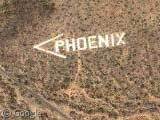
A giant sign just west of Usery Pass, Arizona pointing the way to Phoenix. Neat 🙂
Thanks: Richard Kaszeta
Not sponsored by or affiliated with Google
Saturday, 23rd April 2005 by
A giant sign just west of Usery Pass, Arizona pointing the way to Phoenix. Neat 🙂
Thanks: Richard Kaszeta
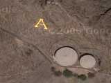
Actually, it’s just west of Usery Pass, in Mesa, Arizona.
This sign is made of a whole bunch of white rocks – whether painted or natural I can’t remember – that were placed there by an aviation pioneer in the late 20’s – early 30’s. At the time Phoenix was not big, and aparently difficult to find by air. It’s easily visible from the ground for several miles as it’s partway up the mountain, on the side of a hill.
This was whitewashed by the boy scouts in the 1950s:
http://www.roadtripamerica.com/signs/phoenix.htm
Just off the base of the sign is the Rio Salado gun range
Glen Farnsworth supervised the repainting of the arrow and the P by volunteers as an Eagle Scout project on January 1, 1999.
I drove by there the other day and saw that the Phoenix sign needs to be re painted again. It’s in sad condition. How many gallons of paint are needed to do this job?
are you repainting the sign? where are you?
Im in Mesa AZ. I went up there to check out the sign. It is very big. Just the I in Phoenix is 12ft by 100 ft. I mesaured it. I can’t imagine how they did this. As far as repainting? Forget about it. Way tooo big of a job.
THIS WAS CREATED BY THE BOY SCOUTS AND COMPLETED IN 1954.
THE MARKER WAS BUILT BY THE AIR SCOUTS SQUADRON 13 OF PHOENIX UNDER THE LEADERSHIP OF CHARLES E. MERRITT. EACH BOULDER WAS PLACED AND PAINTED BY HAND BY THE BOYS OF THIS GROUP, WHICH INCLUDED MY FATHER. THE MARKER WAS COMPLETED IN 1954.
ANYONE WITH PICS OF THESE SCOUTS OR ADDITIONAL INFORMATION, I WOULD BE INTERESTED….