Aerostat, stat!
Saturday, 14th May 2005 by
Aerostat balloons are all along the southern borders of the US. The one shown here is at Fort Huachuca located near Sierra Vista, Arizona. The "Tethered Aerostat Radar System" is a balloon-borne radar primarily used to provide radar data to US federal agencies involved in the "war on drugs". Before these balloons came in the military's radar systems were aimed at detecting high altitude fast moving objects (bombers). Small, slow moving aircraft flying low could easily slip into the US, running drugs and the like.
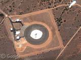

if you pan to the left, you will see the balloon’s shadow
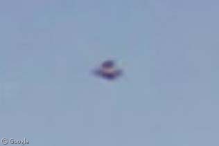
Looks like a DJ’s disc player from way up here
Dang – I suggested this one a few weeks ago…I wonder if I’m doing something wrong…..
Oh my god! they killed kenny!! Can you see it?! oh…ok!
😛
oh yeah it does look like kenny. uncanny. Obviously the makers of South Park went there for inspiration
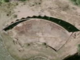
Not a hi-rez, unfortunately, but here’s an aerostat site near Matagorda, Texas.
View Placemark
If you zoom out a couple steps, you can see the cooling pond for the South Texas Nuclear Power Plant (northwest).
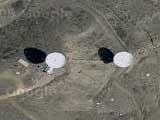
…and here’s the one in Eagle Pass, TX (hi-rez).
View Placemark
The shadow is NNW of this image.
View Placemark is the link to the Aerostat near me, unfortunately a remote area with poor resolution.
And what it is down there? Launch site or what?