UFO Updates
Wednesday, 18th May 2005 by James Turnbull
Thanks to everyone who commented on the original UFO find, although we're still not sure what they are, there's been some interesting developments.
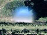
Ian Pottinger and jher were the first to find that there are in fact eight of these UFOs over Florida, at the following points
One - Two - Three - Four - Five - Six - Seven - Eight
and Tensus used keyhole to map the points showing that they make a very neat grid.
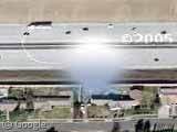
Yoshino and jher later noticed that the UFOs are not limited to Florida but can also be found over L.A.
One - Two - Three - Four - Five - Six - Seven - Eight - Nine - Ten - Eleven - Twelve - Thirteen
and Tensus again mapped the points, which appear in an almost straight line.
Things the UFOs are definitely not...
Space debris or another satellite?
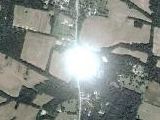
Derek & Tensus discovered that the close-up images of Florida are taken by AerialsExpress.com at an altitude of 17,500 feet so are aerial photos and not satellite images.
Marks added to obscure famous peoples homes?
While there's no doubt the whitehouse photos were processed for security it is very unlikely these UFOs are intentional 'cover-ups' due to the neat grid layout.
Water towers?
The UFOs are just too big to be water towers (and there's no shadow).
Anomaly produced by the stitching software?
Shi Ju says
Definitely they’re NOT marks for picture stitching. In most stitching software (like for making panoramas) the algorithm comes down to finding sharp and contrasting details and aligning those spots with each other.
Things the UFOs still could be...
An alien spacecraft?
It's still possible!
A weather balloon?
Tm says
The "Grid" is centered around an airfield, common launch points for weather balloons.
Although Klem says
All currently used radiosonde devices (weather balloons) are latex, yellowish beige to transluscent
and Jello adds
The object in question here does not cast a ground effect, therefore does not exist in the air.
A 'lenticular' cloud?
Patrick was the first to float this idea and the images he posted do look similar to the UFOs, although it is unlikely clouds would form in neat grids.
Condensation on the lens?
Possibly the current forerunner for most likely explanation, Stuart said...
Condensation inside some sort of housing would be my guess. If the drop were directly on the lens it would be effectively invisible. Put it a few inches/feet away and have the camera shooting with a very deep depth of field (as you would with a small aperture) and it would look just like that anomaly.
Something else?
Possibly one of: Peppermint, baseball, Vogon ship, crop circle, planet, thumbtack, ballbearings, smoke, pond, swamp gas, golf ball, satellite, flying ninja, space junk or contact lens as others have suggested!
all these UFOs were erased by Google. Thank you for your cooperation.
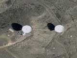
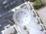
you’ll find this interesting as it’s definately not a weather balloon and google did not delete this image yet. triangular ufo over austrailia 30°30’38.44″S 115°22’56.03″E heres a youtube link incase they delete http://www.youtube.com/watch?v=49Rg6ilvvv8
Check this out go on google maps and type this in 30°30’38.82″S, 115°22’56.14″E can anyone tell me what it is?
It is a radio tower. Note the structure in the center of the triangle. That black line you see is the shadow of the radio antenna on the ground. Those bright spots in and near the corners are bare spots in the ground…..these are there because that is where the guy wires that keep the antenna erect are anchored. This is also also why the formation is triangular, because it takes three sets of guy wires at equally spaced distance to give the antenna the necessary support. Three wires from the very outside corners and three more a little closer in. This explains why there is such perfect symmetry in the bright spots. They simply marked off the minimum necessary land for their facility and built it. The site is probably leased from the farmer who owns the land, so that may be why it is a triangle, using only what land is necessary for the radio tower to be able to operate.
Also, using Google earth you can run your cursor over the ground and read the elevation…..you discover that this particular spot is high ground for the surrounding area, what you would want for a radio tower. The only place that is higher ground is a few hundred yards to the ENE, and as I look at it, it may also be another radio tower.
Hypothesis… IF UFO’s are “cloaked” to keep them usually invisible, might not this unit shown up as partially transparent because the satellite shot was taken in infrared? Just a thought… Also, I saw there is another unit like it over a lake somewhere in Germany. I have it bookmarked on my home PC, not here on my work Comp. You rarely see Antenna Towers out in a lake…
the 2nd ufo update is a cloud. i cant belive someone would confuse it with a ufo! what was that person thinking! the 1st ufo update i belive is a raindrop. i learn about ufos by loking at planes and watching histiory channel subjects about planes and space. i compare ufo pics with plane pica and videos. also i watch the clouds whenever i gt a chance so i can compare ufo pics with clouds. i can tell now when a ufo pic is fake or not. and u cant! haha!!!
These could be UFOs. Why not? they are all over the place. Visible and invisible.
MIRROR anyway i cant c any ufo`s on those pics the dont call it a lie n for nothin
umm right im no scientist but in regards to the comments about condensation, the temperature in outerspace? gas molecules being able to condence into a liquid?….i dont think condensation is actualy an issue in outer space, as these types of molecules would be in a planets atmosphere, not in the vacuum of space…………………………………………………………………, especialy with the lens actualy being the same temp as the surrounding area, its not like a bathroom mirror and someone running hot water…..
as for the condensation on the inside, think about it, all the effort and money to keep a sattelite up there to do various jobs, errors like that cannot be made so procedures would be put in place to avoid things like that.
ALL of them are gone. I think I found this forum way too late. Google sky is out now, with a whole crap load more stuff that looks like aliens.
stop that thing u guys they are meteo baloons i’ve flyed many of them. they are in many colors yellow white gray and sometimes black.as they are going higher they get bigger and bigger because of the pressure of the atmosphere is droping. just before they BANG and fall down again they have the size of a 3 floor building (when they start to fly (2 meters from the ground) they have the size of a person standing ) as the airflows change when they go higher the mey be found many miles away. so dont expect to hear anybody saying “oh yes they are flying baloons in this area” the baloon 5 mins after the release is not visible from the ground and it takes 2-3 hours to reach the highest point and BANG! as this time later it could be found 2 miles 20 miles or 200 miles away of the lanch point. so stop seeing UFO everywhere. its a freaking balloon completly out of focus as the focus of the camera is to the ground many-many feets/meters lower than the baloon. did you ever ask your self why you dont see many birds on the photos? is this leading you to the conclusion that on earth there are no birds? if the baloon was in a lower hight it would have smaller size and then it would have been software-removed.
Hey guys in google earth when swith to the sky you can see something strange first go to july 22 on moon orbit then zoom you will see the green line whats that???
I FOUND 12-13 OF THESE THINGS IN FLORIDA AND 15 IN RANCHO ,CA 5YRS AGO. I POSTED THEM ON MY SITE AND THERE ALL GONE…..YOU CAN’T EVEN FIND ONE ON GOOGLE EARTH NOW THE WAY THEY CHOPPED UP THE GRAPHICS ON THE SURFACE. WHAT ARE THEY HIDING BEFORE YOU GET THE REAL PICTURE?
I’ve got like 5 explanations~ Water spot, blurred water tower, glitch in the all too wonderful Google earth map, blimp, weather balloon, and (one of my best) PHOTO SHOP! OOOOO and what about a CLOUD!!!!!!!! It isn’t a UFO… hence my sarcasm… it’s just a mistake.
wow its a flying matres thats wat all u f o s are i mean i invented them lol jk
Am I so dumb that I couldnt see anything in the pics or somehow they disappear or where deleted?
The aerial cameras used for these kind of photos are placed over a clear window in the bottom of the plane, the offset could be enough to allow a drop of water to form on this window. Air pressure being lower on the outside of the plane this window should bow slightly and allow a drop of water to center in this window. The telling feature here is the East – West lines on which these photos line up. This is the way that aerial photographers take their runs, East – West.
I see nothing, could some point it out to me?
Is this a UFO??
View Placemark (-30.510525,115.3828)
The aerial cameras used for these kind of photos are placed over a clear window in the bottom of the plane, the offset could be enough to allow a drop of water to form on this window. Air pressure being lower on the outside of the plane this window should bow slightly and allow a drop of water to center in this window. The telling feature here is the East – West lines on which these photos line up. This is the way that aerial photographers take their runs, East – West.
Exactly. The neat grids and straight lines that were produced when all of these ‘ufos’ were mapped out are just a result of the straight lines on which the imaging aircraft was traveling and the grid pattern of the stitched together images. It’s just some fouling on the camera housing.
The UfO in Flordia is gone. The one below. “Something Else?”
I think there’s a rip in the time space continuum here:
View Placemark,,0,-2.22
i do not undertand why erase those things. I do not care what they could be, but i feel too much energy to desapearing all of it. i am disappointed.
I wanna know why google has been posting UFO….