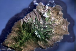
Saint Lawrence Seaway
Friday, 27th May 2005 by Alex Turnbull
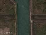
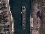
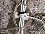
You don't often see a river running under a river! This is the Welland Canal, a part of the Saint Lawrence Seaway which is the system of canals that permits ocean-going vessels to travel from the Atlantic Ocean to the Great Lakes as far as Lake Superior. You can see the size of of the ships a little further South at the edge of Lake Erie (thumbnail #2), and there's another to the North.
10 villages were submerged to allow the construction of the Saint Lawrence Seaway, and apparently a few remnants of sidewalks and building foundations can be still be seen under the water in some places!
Thanks: John Schilling
About the author
Alex has decided that his title will be Senior Vice President of Stuff.
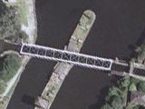
Hmm, but in general a canal is not a river. Canals crossing rivers is not all that rare; for example here’s one such aquaduct near my home.
Dang. I was looking for the places where the Lost Villages were to see if we could see any. But, I found out the area is in low-res, so all I can give is this link. Eh, I tried.
View Placemark,.341606&t=k&hl=en
View Placemark shows a tanker in a lock.
wow
Tom, What is left of Aultsville is the very small lsland in the center right beside the mainland. The larger island to the left is called Ault Island. The most that is left of any of the Lost Villages is submerged roads, sidewalks and foundations.
View Placemark
The URL Tom refers to in his May 31 post is not a tanker but a Laker, a self unloader probably owned by CSL or Upper Lakes and it is entering Lock 1 upbound.
The ship is about 78′ wide and 730′ long. The lock is only 80 feet wide by about 740′ long so you can see the captain has to be an excellent ship handler
View Placemark