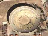
Bullfighting Stadium, Playa Tijuana
Friday, 6th May 2005 by James Turnbull
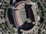
The bullfighting stadium in Playa Tijuana, Mexico. Just to the north of it is the US border fence which stretches across the beach into the ocean.
Thanks: Mike
Not sponsored by or affiliated with Google
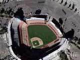
Friday, 6th May 2005 by James Turnbull
The bullfighting stadium in Playa Tijuana, Mexico. Just to the north of it is the US border fence which stretches across the beach into the ocean.
Thanks: Mike
that’s pretty cool.
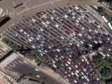
also, are these lots of boats do you think? it’s up to the north of the bull fighting stadium. View Placemark
there were more comments here before weren’t there? am i going mad?
i’ve suspected i might be for a while now actually.
yup, my comment with lots of info on the boats in SD harbor and such is gone.
Rescued from the RSS feed 😀
Posted by: Keith T.
Re the boats: That must be this one:
(from http://www.sdwaterfront.com/knowledge.shtml)
The platform to the west of the boats appears to be the National City Marine Terminal, “a primary port of entry for Honda, Acura, Volkswagen, Isuzu, Mitsubishi Fuso, and Hino Motors vehicles.” (from here)
Also tucked in amidst all that industrial area is Bayside Park, in the center of the channel to the south.
And east of the vehicle storage just on the other side of the train tracks are three rusted circles; these are the remains of three SD Port Authority fuel tanks that were demolished, sparking some local controversy.
Another view at this site: http://www.californiacoastline.org/cgi-bin/image.cgi?image=10114&mode=sequential&flags=0&year=2002
Look to the north… The grass really is greener on the other side.
The capes of Bullfighters are red. Why? I have some ideas, but does anyone of you know for sure? Can you cite a verifiable source?