Alien Civilization
Friday, 10th June 2005 by Alex Turnbull
Please note that some or all of the objects mentioned in this post are no longer visible on Google Earth or Google Maps.
Brilliant bit of weirdness here... Tom Comeau says:
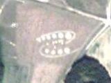
I believe it's winter, and we're seeing snow and ice on the lake surface. But where there's clear water, something very odd is showing through.

About the author
Alex has decided that his title will be Senior Vice President of Stuff.


I guess that’s that. The oracle has spoken. Any further comment is just stupid. Too bad “random” ain’t clever enough to post a link to the coordinates he is all excited about. I am not going to take the trouble to load it up myself, but I would click on a link.
I dont know what it is, but i live near there and gonna go try to find it
Ok, take a screenshot of the image, then paste it in photoshop. Now, you need to create a new adjustment layer, set it to brightness and contrast. Brightness 80 and contrast to 40. Press ok. Go to new adjusment layer choose hue and saturation, boost the sauturation to 80 and the hue to 20. Press ok. Then you create a new adjumsnt layer, select curves. Click the line in the middle to make a new point. Then in the input box put 190, in the output put 100. Now it will become clear to you what the lake hides…Enjoy!!
Ok, take a screenshot of the image, then paste it in photoshop. Now, you need to create a new adjustment layer, set it to brightness and contrast. Brightness 80 and contrast to 40. Press ok. Go to new adjusment layer choose hue and saturation, boost the sauturation to 80 and the hue to 20. Press ok. Then you create a new adjumsnt layer, select curves. Click the line in the middle to make a new point. Then in the input box put 190, in the output put 100. Now it will become clear to you what the lake hides…Enjoy!! If you have any questions, please email me at [email protected]
Hmm, not really. Was that an attempt at a joke too?
Area 51 looks cool on google earth
From these glass lined tanks of old Latrobe…
WTF, I see it now…
Screw all the weird science thories and bable regarding photos. Just look at the darn thing through some green glass. I am out of beer, later!
LOL at all thoes people that think a camera digital or otherwise can see into its self and reveal circuitry… plus if you were seeing a reflection from the water or ice you would not see the insides but rather the whole of the air plane (or satalite… but its not one).
This thing you are seeing is part of a global defence network set up thousands of years ago by the Anunnaki. The only reason why you can see it now is because it had recently been deployed to destroy an incoming meteor large enough to cause a lot of damage.
Other anomolys like the thing at 38’59’15.93N 49’03’59W is just the government using a monopole to hide what they are doing. This affects the path of light which causes the blackened out area and the rainbow affect around the outside of it.
Were on to them!!!! 🙂
i believe that this is the inside of the earth!! as u must know, the earth is en electronic creation of the aliens and all of us are experiments with life.. the other explenation is that the god is a master at electronics and creaated all the universe based on electronic circuits.. but noone is perfect! he forgot to fill this hole and as a result we can see the truth..
LOL
If anyone in the long list of posts has not yet answered the question of where this is, it is called Smithvile Lake. It is in the northern part of Smithville, Missouri city limits.
Isn’t it obivious? NASA has obviously screwed up and loaded an image of Mars onto the Earth page. If they notice what they have done, they’ll probably send men dressed in black to all our homes and kill us all. Look out your windows and be watchful.
I must inform you that the image is nothing but the light of Venus reflected in swamp gas creating an efect of mass histeria (swamp gas tend to do that… well gas in general… specially in elevators). It’s either that or the doing of a couple of english old men with lots and lots of free time… and some rope, very important the rope… -what?-… well, with some rope and old folks you can do just about anything anywhere, I don’t care if its icy water, crops or Nazca, it’s always the old folks… and the gas, do not forget about the gas… gas and rope… allways gas and rope… yeah, and Venus…
Well, in case anyone is still reading and wondering – my theory is quite simple: The camera taking the photo’s will probably have a glass or plastic window that it takes the pictures through. This window may be at a slight angle so, if the camera were to view the image reflected from it, it would see some circuitry within the camera housing (think looking thorugh a car window and seeing part of the cabin reflected). Usually this would not show up – as the light coming from the image would be much brighter and the image would be swamped. However, in the black portions of the image the contrast/gamm correction has actually picked up and amplified these reflections. Now – does anyone know who we email at google so I cdan confirm this and claim my prize? There is a prize isn’t there?
If you go to 39 29′ 18.19″ N, 94 30′ 15.84 W, rotate the picture 90 degrees clockwise, and zoom in to an altitude of about 1200 feet, you’ll see what looks to me like Steven Wright. Or maybe it’s Tom Cruise’s image proving that Matt Lauer is arrogant to believe we may be alone in the universe.
My Theories !!!
It´s a fake.. Someone did that on purpose. Must have been a real hard job. It´s not just adding some layers in Photoshop like some seem to think !! I´don´t believe it happend that way.
The photo was taken in Spring cause the shores of the lakes are Iced and partial covered with snow. Also in the surrounding area you can see some places still covered by snow. The region our “Alien City” is located must be wet, melting Ice. I think it´s not yet liquid water cause the white lines that run randomly (not those of the “Alien” Pattern) must be cracks in the melting Ice (what else ?). So maybe this is really some sort of macro crystaline structure of the ice as it´s reflected and scattered by the sunlight !
It´s an error caused by the CCD of the camera cause of some unusal feature of that surface btw. day and time the photo was taken. The sun was reflecting that strong in an disadvantageous way so the CCD became overmodulated and caused errors. (Remember the old Digi Cams that turned out a black point when photographing the sun ?) This sounds very likely to me but there are some points that speak against this theory.. like the shadow of the trees are very long.. so it´s quite unlikely that the sun is standing directly behind the camera wich might cause a strong reflection. (Maybe anisotropic reflections ?) Also the pattern varies in different regions of the lake. In some Regions you see the pattern fully saturated in other parts they are much less saturated and have a lot less contrast and “buildings” So if it´s a CCD Error I would expect the pattern to be uniform in every place of the lake
What about bacterias ?? There are a lot of lakes.. in Afrika for example that have colorfull layers of bacterias or different forms of gas ! (Remeber that lake that killed thousends of people when a gas layer bubbled up ?) Actually I can not really imagine that those would form a crystaline pattern like that.. but what do I know 🙂
Dont u guys see that this is just someone CPU? GLITCH
Is everbody always so credulous on this site? It’s obvious that this picture of the lake has been edited in Photoshop or some other graphics program. If you look close you’ll see that it’s a printed circuit board.
No, it’s not inverted, I inverted it and the whole thingy got white.
I’m bettin the guys at google are running a sweepstake on the length of this thread. If whoever picked the 28th Oct wins…..I want a share pls.
for all of you wonder what that lake is…its called “Smithville Lake” I live close to it…..
Like the name says, ya just never know. Secrets have been withheld from us before. but really, I don’t care as long as it’s able to be shot with a double barrel shotgun and/or won’t hurt us.
Or…they’re just… hiding sth…
that, to tell the truth, is a underground assembly base for my new company. Hypron. i suggest you people invest stocks when i go public. to be precise, that area that you see is Assembly Plant 5b.
Right first of all it IS A PHOTOSHOP JOB! i do not deny that aliens exist, i also do not deny that your government are keeping secrets from you! (they still deny the existence of an air force base at groom lake) but this is clearly what is known as an “Easter Egg” something the programmers at google put in as a joke! Google Earth is only a Beta and therefore has no obligation to be 100% correct, so i say a couple of guys at google thought it’d be amusing to see how many people they could wind up! (and it obviously worked)
how they made the image :
take an image of a motherboard from a computer, and take an aerial image of a city… define the lightest areas and make them white (making the rest black… now create 3 other layers and copy the white regions of these images onto the other layers (transparent copy/paste eliminating black regions) now select a different colour for the “white rergion” to be in each layer add transparency to each layer save as a medium quality JPEG thus adding artifacts, and hey presto, you have an image worth of being placed “under a lake” admittedly the next step takes a little while to get right but once it’s done it looks pretty good.
if i can actually be bothered i will re-create this image using the aerial B+W photo to prove to you that this is relatively easy, but to be honest righyt now i have far too much college work to bother!
The U.S.Government do have a project called the Smithville Lake Project, (operated by the U.S. Army!) AND the lake is closed during the winter, but unless there is something a couple of meters below the water’s surface it would not be visible.
http://www.nwk.usace.army.mil/smithville/whatwedo.htm
This is clearly a Hoax, Google like to be jokers… look at the Google Moon Beta. http://moon.google.com keep zooming in, until it wont go any further and you will see why i believe google would go to the effort of putting something amusing like this in their software.
as i said before, i do not deny the existance of aliens at all, infact to say “THERE ARE NO ALIENS” is very narrow minded, here in the uk i and my friends have seen UFOs (bear in mind all a UFO is an object in the sky that is moving that cannot be identified) which definitely were NOT aeroplanes.
but THIS is NOT aliens, and this is NOT a government conspiracy,
its a photoshop or paintshop pro job!
This isn’t anything that’s worth discusion. If anyone wants to know what it is then travel to it. It’s not like you don’t know where it is. For anyone that has visited it and didn’t see anything out of the ordinary, then forget about it.
This is a rather… wierd thing. But I have one thing to say: 42.
Earth is a giant computer program to find the Ultimate Question!
YES IT IS!!!!!! HITCHIKER GUIDE TO THE GALAXY!!!!!!!! YAY!!!!!
I knew it!
lol, but its actually what i said it was: “that, to tell the truth, is a underground assembly base for my new company. Hypron. i suggest you people invest stocks when i go public. to be precise, that area that you see is Assembly Plant 5b.”
Seriously!
I guess that is the Machine City in Matrix!
On the google earth program, that part of the lake is programmed to show the inside of your monitor by making it transparent, so, when you look at it, you see the inside of your monitor. simple.
Come on lets keep this thread going and we can break the world record for the longest running thread.
I think David Copperfield lives there. No kidding – maybe I’m gonna scare you conspiracy theorists: the thing is really there! The parts of the lake clearly each have their own, distinct portion of patchwork, so it is not just an imaging effect. And – submerged farmlands do not create overlapping colours, would they (and why only there)? It’s the camera compensating the over-exposed icy planes surrounding the dark lake, in combination with slight natural differences in the different sections of the lake.
After looking at the picture I have come to a conclusion that it is ice with different layer, making like a crystal effect seen from the sky. how ever maybe lake is filled with diamonds. LOL
I’d guess that parts of the image were too ‘white’ and therefore out of the capture range of the sensor. That looks like a CCD or CMOS sensor to me.
Shit thats pretty damn freaky…
Whoa, man… it’s like the satellite can see right into itself, man! Far out, dude!
I bet it is a bug in the image processing software. In order to improve the contrast of the image, a background level is subtracted from all pixels. The background level is probably a cubic spline over some model. In the cases where the foreground is very dark (ie the pixels are close to zero in RGB), the background model might be slightly larger than the foreground. The result is a negative number. Unfortunately, there are no negative RGB values, so they overflow and becomes very positive. Since the colors are clearly 100% values of cyan, blue, white or magenta, this seems like the mostly likely answer. For example, if very very dark red is the RGB value (1,0,0) and the background is assumed to be dark grey RGB(1,1,1), the subtracted image looks like (0,-1,-1). However, there are no negative values, so it looks really like (0,255,255), which is 100% green and 100% blue, which looks like cyan.
The software either has a bug in the background spline algorithm (ie it rounds up instead of rounding down) or the subtraction is not using saturating arithmetic (read up on DSP processing).
Either that, or the satellite got a little chunk of carbon stuck in its nebulator valve. Happens all the time. Betterfastercheaper.
I’m guessing its cracks or lines in the ice. Maybe when the light hits these cracks it looks like light thru a prism.
Obviously you guys are all wrong. I agree with SoObvious. The Matrix was assimilated and the Borgs were victorious at the breakdancing competition. As for Tron… lets just say that he won’t mess with Neo anymore! Neo got blown up and landed in Machine City where he met the Borgs and teamed up with Tron to breakdance all night long! PARTY!!!
With the image database updates, this is now gone in Google Earth. Google Local still displays it, though, so enjoy it while you can.
我日
This is smithville lake the water is fairly shallow and is often frozen over in the winter
i can´t see that alien civilization in google earth!!
Sadly it also looks like that in the year 2008 this photo also got updated. The weird alien looking thing is not there anymore 🙁
i want to sign up to receive the serendip software.
do u contact to the aliens? if yes than how?????????????????????????