Hojack Swing Bridge
Monday, 13th June 2005 by Alex Turnbull
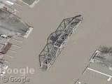
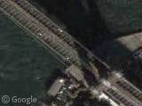
This is the Hojack Swing Bridge on the Genesee River near Lake Ontario, which is slated for destruction. Seems a shame, 'cos it looks pretty cool from up here. Scott Ventura says:
There's a movement afoot to save the bridge (which also has a ground-level photo), but the Coast Guard wants it gone since the owners (a train company) haven't used it in years.
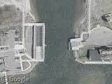
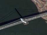
A little to the east lies the mouth of Irondequoit Bay, where you can see a pivoting roadway that closes off the bay from the lake in the winter months. The roadway, which forms part of Lake Road during winter, is visible here on the west bank in it's its storage position. I've been told that it takes fifteen minutes to rotate it at the beginning and end of the season.
Thanks to Scott Ventura.
About the author
Alex has decided that his title will be Senior Vice President of Stuff.
Please tell me I didn’t put an apostrophe in that “its”! It must’ve been 2:30 in the morning for me to make that kind of mistake.
Dammit! No Scott, you’ll be glad to hear that your punctuation was perfect, I’m afraid the error was mine!
hangs head in shame
how neat & small[er] the world is thanks to the internet. While browsing one of my favorite stock photo sites, they had your page up as one of their featured “The Skinny” pages. And so I go thinking this is purdy cool. Only to find Irondequoit Bay pics on your page, which is just down the “road” from where I am sitting in Rochester. Funny. Small. Neat.
This is a very neat site, guys, keep up the good work. [And I like your cross out of the “it’s”. It makes the webpage more human and less computer.]
Oh- and apparently I need a thesaurus for the word neat today. I am sucha geek.
That’s a great find. Neat Bridge, i love checking out google maps.
Ther’s another open swing bridge in the south end of San Francisco Bay. Scan down the track and you see that the bridge ends. Scan to the other end and it looks like the road next to the track ends at the water’s edge too.
I looked at the Irondequoit Bay map and assessed how long the route is the long way around (if the pivoting roadway is open) It looks like a pain in the butt where 590 and 104 come together. There are NO connecting ramps for that route. It looks like you have to get off E Ridge Road and cut over on Culver Road.
Yup – there are NO connecting ramps for 104 to 590. You have to get off E Ridge Road and cut over on Culver Road. They were started when the Bay Bridge was build but never went much beyond the Bay Bridge