Montserrat
Monday, 20th June 2005 by Alex Turnbull
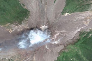
This is the Soufriere Hills volcano on the Caribbean island of Montserrat. Although seismic shocks had been felt on 30 year intervals for most of the 20th Century, the volcano was still considered inactive. However it became active with devastating effect on July 18, 1995, eventually causing two thirds of the inhabitants to evacuate the island. Its eruptions have rendered most of the island uninhabitable, and yet people still continue to live there.
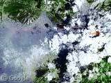
In the satellite image you can see where the abandoned capital city of Plymouth used to lie, buried underneath the grey area on the southwest of the island, and through the clouds you can also see the glowing red lava in the volcano's crater. Scary stuff!
Thanks to Robert Sargant for this one 🙂
About the author
Alex has decided that his title will be Senior Vice President of Stuff.

Sharing statistics
Share this site