Desert Farming
Monday, 27th June 2005 by Alex Turnbull
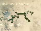
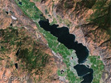
Check out these bizarre circles of farmland smack-bang in the middle of the Libyan desert. This unlikely-seeming sight has been made possible by the construction of the Great Man Made River, possibly the largest water transport system ever built, consisting of a network of pipes buried underground, each four meters in diameter. In the 1960s, efforts to find oil in southern Libya led to the discovery of huge quantities of fresh water underground, and today the Great Man Made River carries more than five million cubic metres of that water under the desert, vastly increasing the amount of arable land.
However, I'm told that apparently these sources of water (which were deposited in the ice age) are only likely to last between 50 and 100 years, yet the project is estimated to have cost 25 billion US dollars.
There's lots more of these circles around to support this theory, but does anyone else think what they're actually doing is trying to draw a picture of a giant dog?
Thanks to Tom Beddard, Stuart McGlashan, Steve Rot, pixiecrinkle, Mark and Phillip.
About the author
Alex has decided that his title will be Senior Vice President of Stuff.
Anyone know what they’re growing there?
Whatever they are growing has to be transported by air (note the airfield to the north west. There appears to be only one minor road exiting to the north.
Talking about weird stuff in Libya, I suppose this is Mount Uwaynat: View Placemark
Can anyone tell me why it’s blue? That can’t be water, can it? In these pictures taken from the Space Shuttle, it doesn’t look all that blue: http://eol.jsc.nasa.gov/sseop/clickmap/map109.htm http://img76.echo.cx/img76/5497/isdhighressts099sts099742299ex.jpg
I couldn’t help but notice the gigantic smoke plume next to some of the “farms.” I wonder what that is!
something’s in the water northwest of those green circles.
View Placemark
I wonder what the hell is this:
View Placemark
Probably something transient, like an enormous fire?
Ah, now we know where they really moved their virus-laden corn growing operation at the end of the X-Files movie…
East of the “dog of circles” you can find the famous “line in the sand” you’re always hearing about:
View Placemark
Those are irrigation circles – found throughout the midwest, def. nothing special
You can tell those farm circles are recent, because they are arranged hexagonally. Had they been older farms, the circles would almost certainly be arranged orthogonally (square matrix) to fit onto the older fields. I guess when you are tied to an underground channel of water, you’re encouraged to make efficient use of space, unlike us lazy Americans. WTG.
Frankj:
Zoomed in, it certainly does look like water, definitely a flow of some sort.
It’s hard to compare with other satellite imagery. Not all satellite images take pictures of visible light — some (especially NASA) take pictures of infrared and then turn the infrared part into green, etc… it’s arbitrary. Take a look at the meta-info on the Mars Observer pictures sometime, they explain the six different filters they use and usually say how they’ve been combined into an RGB image. Also there’s the question of how high was the satellite and what angle it took the picture at — maybe Google’s imagery was such that it reflected the blue sky in the water, and the others don’t
But FWIW, you can still see the flows in the Echo.cx shot, they’re just not blue.
here’s more:
View Placemark
not sure which country that’s in though since i started in egypt.
‘Anyone know what they’re growing there?’ -Yes, the dark circles are wheat and the lighter circles are alfalfa.
It seems that these structures belongs to the project Great Manmade River (GMR), a network of pipes that supplies water to the Sahara Desert in Lybia from a fossil aquifer in the Sahara. More info on en.wikipedia.org/wiki/Great.Manmade.River
Again, some more irrigation circles: View Placemark
It’s interesting how distinctive farms from different regions of the world appear. The farms of Syria appear as long stripes running every which way; in India the fields appear as little almost but not quite square areas arranged a little like plant cells; in Cuba and Hawaii they look larger overall, and so on.
These are wheat circles at the Sarir agricultural project originally a Libyan/USA joint venture from the 70’s. They are irrigated from existing water wells not the man made river project. The smoke/flare and airstrip mentioned in other posts are part of the Sarir oilfield operated by the Libyan AGOCO Oil Company.
Slight Clarification on my last post, the wheat circles shown in the photograph above are actually in Kufra Oasis the Sarir project is to the North where their layout is much more regular. N.B.Water from both these areas is now being fed into the manmade river. the majority of this water is destined for the coastal areas and is already being used to supply domestic users in Tripoli
ok so i was looking on google satelite with my friend night and came across these green circles.i thought they were aliens.lol.so i decided to look up more about em on google.ii just really dont know why they would have irrigation circles in the middle of the libyan desert.it makes no sense.kinda freaky.will someone please explain more to me if they can.id like a better understanding
http://en.wikipedia.org/wiki/Irrigation_in_Saudi_Arabia
I reeped 2 crops a year off of 80 circles at Wadi Aril….about 2 hours east and a little north of Sebha. The council had okayed 99 wells when I left for home. NoOne eclipsed my 80. Rick // FDC // Pasco
hello hello and chelas! ciao bella
The circles at Kufra in Libya were installed beginning in 1972. Each circle is 1850 feet long and represents 100 hectare. The first machines installed were produced by the Ames company in California. Ames has been out of business since about 1973. These machines worked, but were fraught with problems. Then Alsa (an english company) sold a half dozen aluminum machines, but they were not all installed. The coefficient of thermal expansion over 1850 feet would rip any standing machine apart. The French (Irrifrance) sold 27 machines, but the fell down as fast as they were installed. bad design and extremely poor workmanship. Over the next few years, Lockwood Corporation (Gering Nebraska) installed 10 machines of the Ames design and another 80 machines – replacing most of the the Ames, Alsa and Irrifrance machine.
The Kufra is an oasis. There is standing water at the heart of the oasis, but it is extremely brackish. The entire southwest and west of Libya and the eastern part of Egypt is above a very large underground water lake – the Nubian aquifer. This aquifer is stagnant. There is no flow. The elevation of the water table is the same through out the aquifer. An oasis is where the level of the land (sand) dips down to expose the water at the top of the aquifer. Since the water at the top of the aquifer is very brackish, there is a well at each circle that goes down some 1500 feet. While the water artesians to within a few feet of the surface, the irrigation water is actually drawn from a depth of 1500 feet. Since the water is stagnant, and under a great deal of pressure (nearly 700 psi) at this depth, it contains dissolved CO2. As the pressure is reduced, this goes to a week carbonic acid. This acid will eat through the conventionally galvanized steel machine is a few short years. This is why Alsa attempted to use aluminum. The Lockwood machines were constructed with steel, but lined with stainless steel.
I have pictures of the installation if one would like to see them.
Clif
A group of us ,Kiwi’s Aussies and Americans installed these pivot irrigation systems in 1980 ( Jan to March ) It was overseen by the French Government . I think that they bankrolled the project . You should be able to count 84 circles but some died very early on. here is a rumour that they are to be rebuilt.
Dessert farming, I worked this and other sites from 1982 -1984. This site is (Northern 6 rows) Is Sarir North which was run by the French. The southern 10 were run by Food Devlopment Corporation (From Pascoe) FDC also ran two other sites Wadi Aril and Maknussa which are Norht west of Marzuq. The crops we grew were onions, potatoes, sorghum at Sarir with wheat and corn at the others. FDC were also involved in setting up a dairy in Sabha which had 500 Fresian cows and two bulls but they couldn’t cope so 2 Holstien crosses were brought in to help out
Hello I ‘ll be there in two months. ı ‘ll send detailed photos
My name is Steve Hefner. I was the agronomist at the Arizona State University research farm beginning in 1973. ASU was a part of the consulting group that helped to setup the Kufra project just before I began working at the university.
Sarir project was setup approximately at the same time run by the French government.
In 1973, the Lockwood Corporation sent two men to the ASU research farm over Christmas break and we worked together building a small demonstration center-povit sprinkler system identical to the Kufra machines. The idea was that if problems came up in Libya our researchers could workout a solution without having to travel to Kufra.
In the end, the machines had steel joints/couplers between sections of aluminum pipe that rusted severely causing leaks, while rust particles clogged the fine mist sprinkler nozzles. We grew alfalfa under the sprinkler at the ASU research farm. In the Arizona summer, I ran the irrigation system as fast as I could 24 hours a day and could just barely keep the alfalfa alive. The nozzles put out an extremely fine mist which was totaly wrong for desert conditions. Evaporation and volume of water dispersed were the biggest issues. Modern L.E.P.A. systems would have solved these problems.
At the Kufra Project, they grew wheat and alfalfa. I believe most of the wheat was shipped by truck back to the cities on the coast, while the alfalfa fed sheep and maybe goats that were brought into Kufra. The sheep grazed the irrigation circles and excess alfalfa was baled sent to the coast.
Ok guys, this isn’t some sort of rocket science, all they’re doing is accessing the ground water/water table, same as if you were to drill a well. This is possible in most of the world and they’re circles because its easiest to water that way. You can find these in the states as well. Granted technology in the 60’s was much more limited than it was today but if this truely was discovered through oil drilling, they were quite bad at what they did as oil is found in a different sort of rock composition. You can drill anywhere, depending on the depth you’ll eventually reach the water table, hence why mines need to pump water out as they dig deeper.
Steve Hefner: I’m confused. I was VP Engineering at Lockwood from 1969 through 1979. Originally, the Libyans were sold a half dozen center pivots by Jim Ayers of Ames Irrigation Company in San Jose. The Ames machine was an untested design with 250 foot spans and an aluminum pipe suspended beneath the structure. It was underpowered and generally badly designed. But Jim did a great “sales” job on the Libyans. BTW, did you know Mahmoud Khatab? He was educated in Az and married a Joan from there – later became head of the irrigation project until he was caught with his hands in the till. Mahmoud was convinced that the Ames machine was the way to go, even tho it didn’t “go” in the desert – or anywhere for that matter.
Meanwhile, the Irrifrance copied a Lindsay pivot and sold 15 or 20 to the project. They were such a poor copy and the workmanship was so bad, that as fast as they were assembled, they fell down. Lockwood (President Fred Schneider) entered the picture and was asked if Lockwood could fix the Irrifrance machines and install them. Fred and I visited the site and surveyed the project. While climbing over the pile of Irrifrance pipe, I accidentally kicked a pipe flange and the weld broke.
Since Mahmoud was well programed by Ayres, he also wanted us to supply some new machines of the Ames design. So, we bought the Ames company – not just for that reason, however – and set out to produce the Ames design. I have absolutely no recollection of sending anyone to AZ with a mock up for testing.
Anyway, we did send a crew – 20 – 25 men as I recall – and did fix the Irrefrance machines and install a dozen or so of our Ames design. I managed the project from Lockwood. The on-site manager was Keith Rogers (see RAAFT.COM).
This successful enough that we were able to supply a quantity of pivots of the Lockwood design. This machine used 120 foot spans. The irrigation pipe was the structure of the machine. However, since the water was acetic and would consume the zinc coating, we lined the pipe with a thin stainless tube. It was explosive formed inside the finished pipe. As far as I know, these are still running after 30+ years.
We used drop spray nozzels to lower the distance that the water had to travel from the pipe to the ground and to control the fine particles inhearant with impact sprinklers. These fine particles would evaporate before hitting reaching the surface. Besides using stainless steel liner, we applied our experience with Ames and Irrifrance to use specially designed motors, controls, etc.
Dylan: Water was not discovered by oil will drilling. The Kufra had long been irrigated with hand move pipe using the brackish standing water in the oases. The Nubian aquifer was well known long before Occidential Oil started drilling for oil. It is a huge aquifer running from Sudan through much of Libya and into Egypt.
Oops, Mahmoud Khatab came after Mohamud Karah. It was Karah who attended AZ state and married Joan. Khatab replaced Karah. Sorry.
I was at the Wadi Aril Project during 1983-1984. I believe we had 130 pivots, we were growing wheat and sorgum. I was the last American to leave this project.
Thanks to the wonderful work of British Caladonia. I owe them my life.
I was the creator, in charge of developing, installing and the operator of those 100 machines.
I read all the information above and everyone covered some part of this uniqe project.
I could writh a book about this project. I purchased the first machine in 1969 and then another 100 machines an year later. We bought these machines from 3 different companies: American, British and French. We want to see which one will be more successful. Each machine irrigated 250 acres from one deep water well. The reason these machines look like a picture of a dog is because we have to plot those 250 acre circles around some hilly areas and also to avoid the severe water draw down if we have them competing with each other in one big square field. These 100 machines irrigated 25,000 acres. Because of the limited amount of water the plan was to have the inner circle in alfalfa and the ouside in wheat. In the winter we could irrigate 250 acres and in the summer we could irrigate only 125 acres.
So Mohamed, you must have worked with Howard Karchner?
Mohamed, it is interesting that I should come across you in this manner after – what has it been? 35 years?
My time working with you was an experience!! After you left the project, it was almost impossible to get anyone to make a decision.
Where are you now? In the states? If you ever get to Omaha, email me and I’ll buy you a drink. You can reach me direct at [email protected]
I did not see my comment to Clif so I repeat it again: First: I believe you should apologize to Mr. Mahmoud Khattab because he is a very decent man. Second: I and everyone else and without exception believed that Ames Machines were the best. All the machines that came in 1970 had the same two major problems: CO2 & thermal expansion.
To Clif & Mohamed: I have to admit it has been a long time ago since I helped build the single leg center pivot machine during Christmas break. I believe it was made by Lockwood but I could be mistaken.
Three Arizona State University – Department of Agriculture faculty members that formed a team that actually visted Kufra consisted of Drs. Daniel Robinson, Grant Richardson and Grant Moody. Do you remember those names? To the best of my knowledge, ASU ‘s involvement in the project ended in 1974 with the change in Libya’s policies toward the U.S.
Yes, it has been a long time. The first machine that was installed at Kufra, was an Ames machine. It was used 250 ft spans. I can’t recall if the machine was 100 hectors machine or not. Likely it was only a quarter section machine. It is likely that this is what you tested. When you refer to a “single Leg Machine”, I assume that you tested only one span, not a full quarter section (or 100 hc) machine.
Lockwood purchased the Ames company in about 1972. Partly for its hand-move irrigation product line and partly because Mohamed wanted that design. We produced and sold 5 of these machines to the project and took a contract to field fix and install some 25 (not sure of the exact number right now) machines that were produced by Irrefrance.
Irrefrance made an unlicened copy of the Lindsay machine. Unfortunately, it was a bad copy and had even worse workmanship. But we got it done.
Later we had a contract to replace the Irrefrance machines with our own bow-string designed machine.
I do recall the names Moody and Robertson, but that ‘s about all. While we are checking names, do you meet Keith Rogers, Jack Huff or Clayton Enix on site?
I left the project in 1973 for personal reasons. An official delegation from the Department of Agriculture and the Project came to the State to convince me to go back but I was not able to. I, therefore, did not know what happened afterwards. Yes I did order the Ames Machine and it was installed in Kufra in 1969. It was the first pivot machine that was installed in Africa, Asia and the Middle East. It was a 50 hectares machine and we were planning to put 50,000 hectares or 125,000 acres under irrigation by the pivot machines. We did not have any problem with Ames Machine because the CO2 and themal expansion problem were not severe enough. Ames machine was a heavy and lower machine and therefore had less problem with the wind. Before we decided to buy the first 100 machines we went to France and England to inspect those two machines plus our knowledge about the Ames. The French were copying Lindsays and the british have an aluminum main pipe to overcome the CO2. We were extremely happy with the Ames but because of the future expansion, we felt that we shouldl try some French and some British therefore we bought 80 Ames, 10 French and 10 British. The rest is history. Yes we worked very closely with Dr. Robinson’s team and there was a wonderful friendship and cooperation. I did not have any idea about the machine that was installed in Arizona and I would love to hear about it in more details.
I don’t remember any names of the two people I worked with from Lockwood. I assume they were company technicans or maybe even independent contractors sent to assemble the system. > I don’t believe the university ever got to use the machine for troubleshooting problems at Kufra, because either the consulting contract ran out or the political climate got so bad the project was abandoned by the U.S. companies involved. > > Yes, as I remember, it was only one section of a 160 acre machine. It had a 1 hp. electric motor geared to 220:1 (I’m not sure of the exact gear ratio but I think it was listed on the machine) to drive the two rubber tired wheels at the end of the machine. It would get stuck in our clay soil if I slowed the speed down too much. > > Dr. Robinson was an agronomist and former department chair of the Agriculture program here, Dr. Richardson was an agronomist and Dr. Moody was actually a dairy expert. > > About 13 years later (1986), I met and worked with a Libyan graduate student here at ASU, Saad El-Aligouri, who worked for a short time at the French sponsored equivalent of Kufra. I used to have a 16mm film describing that project, but I can’t find it. >