Air Base Weirdness, Iraq
Thursday, 30th June 2005 by Alex Turnbull
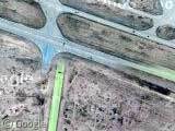
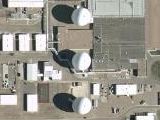
There's something very odd going on at this air base in Eastern Iraq. Quite apart from the aircraft parked on the runways, there's some serious image misalignment, and what on earth is going on with the colours?
It’s the weapons of mass destruction! We found ’em!!
I knew they were out there
Regarding google maps, could you post the coordinates along with the images? That way, us google earth users can just paste them into the ‘Fly To’ text box and go there.
so, for this one, the url is: View Placemark and the relevant coordinates (in the right format) are: 32.930875,39.747591
Keep up the great work!
They may be using color infrared for some stuff, and then correcting colors later. IR gets more contrast on some subjects. And in the desert, they don’t have trees to reference when correcting the colors.
I think these images and the Libyan images prove that at least some of the high res is really satellite, and not aerial photography. What civilian agency would be flying planes with photography rigs over Libya or Iraq?
Try here for the WMDs: View Placemark
somebody ja found a Crater of Meteróro?
found Meteor Crater?
Actually, HERE is where most all the WMDs are:
View Placemark
Steve.. you mean Ontario?
I knew it. Those bastards in the east were the cause of all this trouble all along. Thank god I live in the west!
I thought all the WMDs were here?
http://maps.google.com/maps?q=van+nuys&spn=0.126060,0.162100&t=k&hl=en
Wait. Sorry. Those aren’t WMDs, but they sure cause a lot of explosions.
Just north of the run ways you can see the buildings that have had the shit blown out of them.
No sorry guys this is where the WMD are!!!
here
sorry link didn’t take… i ment here!
View Placemark
I am constantly amazed that a government (U.S.) that is so paranoid about terrorist attacks that it won’t allow tourists to photograph public buildings and bridges, is O.K. with publishing aerial/sattelite images of military installations (in the U.S. and overseas) and of an active warzone. While there is nothing inherently secretive about the layout of this Iraqi airstrip, it does provide for cheap, accurate, easy to obtain imagery that could be used by poorly funded groups to plan an attack.
yeah, but it kills the time
Did anyone notice they have pixelated the US Capitol building recently?
why have goog maps changed the satellite/map toggle buttons? Is this to do with the new ASP thingy (or whatever its called)?
The airfield is the “H-3” Airfield: http://www.globalsecurity.org/military/world/iraq/h-3.htm it was bombed in sep 2002.
These images are almost certainly taken with DigitalGlobe’s Quickbird satellite, although I don’t know why the strange colours here. That satellite can achieve up to 70 cm resolution in B&W mode from 450km up. The images that you see where an airplane has a “blue shadow” are from the quickbird satellite as well.
New military technology for night landings: Indiglo runways. ;P
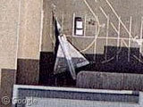
The aircraft “parked on the runway” isn’t parked on the runway. it’s landing.
or probably just flying over the airfield.
I think that the green areas are were there is some Tiberium. Damn my mispent childhood.
Maybe the whole thing was highlighted with a green marker
i think the government had some guys playing around with photoshop on those images. so you cant see whats really on those runways they added wierd colors
OK, nothing to do with WMD or Iraq, but I also noticed some extremely bad misalignment around Naples: View Placemark
I could not believe that the images of my house was shot at a fraction of a foot (3inches). I thought that now I could see everything bigger than 3 inches that I could recognize on the ground. Well I think I am wrong about what it means. No bear cans in the yard and worse, I could motorhome but not the 2ft ac’s on the roof. Anyone know the correct meaning of xinches or xmeters resoution?
I think that the green areas are were there is some Tiberium. Damn my mispent childhood.
Yes!! I just started playing this game again, pwn!
It’s the new technicolor runways
It’s where the Iraqis have painted their runways green to confuse the American bombers, and lead them to believe they have had too much weed.
That is the complete and full explanation.
Peace.
x
Color: as mentioned if infrared is used, than it could be day and night? Alignment: just two different photos, explains the colors as well?
I think this is some kind of nightvision picture (the colors)…
I agree with Ben Brockert’s post, I think these images are color IR, which show vegetation red (not much of that here), and concrete surfaces typically show up bluish.
I also believe that this image was taken during the Iraq war, and shows aircraft and other equipment parked on the runway to prevent Coalition aircraft from landing.
probably aircraft were parked perpendicularly to runways to prevent landings .. only way to aland would be to land choppers drag planes off and then land