Amboy Crater and Lava Field
Monday, 20th June 2005 by Alex Turnbull
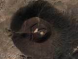
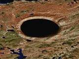
Next up is the Amboy Crater, an extinct cinder cone in California's Mojave Desert. It lies within a 70 square kilometre lava field, and it looks pretty impressive from up here!
Thanks to Art Jones.
About the author
Alex has decided that his title will be Senior Vice President of Stuff.
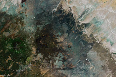
Anyone know what the gird of pits and ridges to the south east of the lava field are?
The roads around that area are labeled “Salt Evaperation Plant St”. So I am going to guess it is a salt evaporation plant. Looks very interesting.
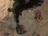
Can anyone explain what the dark marking extending SouthEast of the crater is? At first I thought it was shadow, but the sun is coming from the wrong direction. Is this the path of a massive lava flow?
John in response to your question, it may be ash residue that has blown from the North West winds and, over most likely many hundred years, has discoloured that area behind the volcano. Granted I’m not a geologist but it seems to be a plausible explanation to me.
Chris G… looks like it to me, but it could also be winds having blown black volcanic dust in that direction. I zoomed out and there looks to be some smaller areas (vents maybe) that have the same tailing effect. This is a guess on my part
I guess i should have said John not chris… I posted to late and didn’t read
I was there about a year ago, and there are fields of black lava rock extending away from the crater, which I suspect explains the “shadow area,” although I can’t say for certain that I remember them being primarily in one direction.
I thought I had some good pictures of it, but I must not have uploaded them. This page describes the lava field, and you can see the rock I’m talking about from the ground in these pictures.
I just came back from camping in the Mojave and I can tell you it’s definitely lava flow. Here is a picture I took from a trail extending from Amboy Rd. looking west, toward the crater.
And this is a close up of the rock surface.
http://img515.imageshack.us/img515/7079/img0383pu7.jpg
http://img181.imageshack.us/img181/5416/img0384uu6.jpg
Juliet is correct. The lava flow extends miles away from the crater, though I am not sure how far it extends in all directions. You can access the crater from the north side so that gives you a good idea as to how far the lava field extends. You can only access the other side of the crater by hiking and climbing your way through the lava rocks and desert.
For interest, that road that runs across the north side of the crater is Route 66 (with railway line running north of that again), and if you zoom in to the T junction just to the north east you’ll see the town of Amboy itself and the roof of the famous Roy’s diner. I drove this area in May this year and the desert is so flat and lifeless it’s like the moon and the blue salt evaporation pits are just surreal.
I think it’s about fifty miles down Route 66 from Newberry Springs, where the classic film Bagdad Cafe was shot.