Google Sightseeing takes you on tour of the world as seen from satellite, using the free Google Earth program, or Google Maps in your web browser. Each weekday your guides James and Alex present new weird and wonderful sights as suggested by readers.

The editors: James & Alex

Hole In The Coast

Posted by Alex Turnbull, Monday, 11th July 2005

1 Star2 Stars3 Stars4 Stars5 Stars

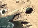
Update: After much debate in the comments of this post, determined reader Patrick has finally tracked down the truth about this mysterious location! Patrick contacted a friend who lives in Mexico and she pointed him towards this forum thread, where he discovered that this is a place called La Lobera; and our ‘hole in the coast’ is in fact, a collapsed sea cave. There’s some brilliant images of the hole and the surrounding area in the thread, some of which show the structure to be of pretty staggering size.

Many thanks and much kudos to Patrick, as this was driving us nuts! :-D

Anyone know what this strange hole in the coast of Mexico is? Weird.

Hole In The Coast

Thanks to Joey Shabadu

51 Responses to 'Hole In The Coast'

  1. Lars says:

    Looks like a blowhole.

  2. Jake says:

    secret army base…shhhh…

  3. Yorgle says:

    James Bond villain lair?

  4. Maybe, the building of a lighthouse?

  5. Sean says:

    Thats where the little pod thing drops through after you fall through the rotating thingy and travel through time. Like on that movie Contact.

  6. Mayweather says:

    It’s so obvious: a castle made of sand, built by some mexican children on their vacation.

  7. Tim says:

    A blowhole sounds right, but why does it have those markings surrounding it? Does this place have religious significance?

  8. The Govinator says:

    So you don’t fall in or get to close

  9. CODY says:

    THATS MY HOUSE!!!!!!!!!!!!!!!!!!!!!!! there is treasure there……..please do not dig up the treasure

  10. Jack says:

    Googling Blowhole “Baja California” came up with this link, which I believe is what is pictured.

  11. Martin says:

    Looks like a temple mound to me. Just look at the shadows. It’s not a hole but rather a mound or temple. The markings are likely smaller stone piles of religious significance.

  12. cacafuego says:

    The yawning pit of hell??

  13. Twombly says:

    Yeah – look at the shadows – they all go to the north west, just like the shadow in the hole! BTW – it is not La Bufadora, the blowhole in Baja Mexico. It is pretty close to El Rosario, but my searching stalled out there…

  14. Parker says:

    I’m with Twombly. It’s definitely not La Bufadora. I spent several hours researching the Baja coastline to solve this puzzle. To the ESE of here is El Rosario, a small agricultural community. San Quintin is to the north of this site, but the main highway in the area (Mexico One) follows the coastline only a short while as it heads south from San Quentin, before veering inland and heading in a SW direction toward El Rosario. Our mysterious hole in the ground appears to only be reachable by some long and treacherous winding dirt roads (read: mud, deep sand, possible flooding, and cacti in the path) through the mountains, and seems to be undocumented on the Internet. Let’s just say that I’m VERY curious now.

    I should also add that I’ve never really studied the geography of the Baja before and now I’m very intrigued. I’ll have to plan on an adventure out there at some point in my life… seems like a two-week road trip through that breathtaking countryside would be an amazing experience for a Gringo like me.

  15. Parker says:

    Pardon me, the road heads SE from San Quintin. If it headed SW, it would end up in the Pacific ocean.

  16. Hoodoo says:

    If the Earth were to receive an enema, that’s where the nozzle is inserted.

  17. EdZ says:

    The markings around the edge are probably fence posts. It wouldn’t be suprising if there were a fence around such a large and abrupt hole in the ground.

  18. raphael says:

    a nuclear silo
    or some sort of weapon of mass destruction
    it’s time for good old bush do something about it

  19. chris says:

    It’s a sandtrap I tried getting out of at Pebble Beach

  20. Neil says:

    It’s one of those big Jedi-eating pits like on Tatooine in Star Wars

  21. Treeshrew says:

    Hmm…
    A. I did some research but got stumped at El Rosario
    B. Parker: if you’re gonna do that, bring a gun :-P

  22. Patrick says:

    I think this might qualify for the weirdest yet in the weirdness category!! It seems like there is some sort of steel and glass structure just to the left of the hole, a couple of vehicles……and if you follow the one road that leads into the place it doesn’t really seem like a public use type of road…..a dirt track really. Perhaps it’s a summer retreat for the Bohemian Grove club and they use the hole for sacrifices?? Is there a way to download the images so as to blow them up in PSP for greater detail? I know they were able to do it for the “ufo” pics….

  23. Mike D says:

    It’s also very odd that the flat area seems to be man-made. Looking up and down the coast, there are no flat areas like that.

  24. Fehler says:

    It’s a tide pool. A very large one.

  25. Kati says:

    I don’t quite believe that it is a natural tide pool… I spent my lunch break trying to figure out what it is and had no luck. Not that I am any good at geography but it looks just south of El Rosario unless I am WAY off. (which very well could be…)

  26. Keith T. says:

    It’s NOT La Bufadora. La Bufadora esta aqui, cerca Ensenada:

    Placemark: Google Maps / Google Earth

    See map at:

    http://www.advantagemexico.com/ensenada/images/baja_north.pdf

    The spot we are looking at is much closer to El Rosario.

    On Mapquest it seems to be very close to a point named Campo Las Mujeres — but Google turns up nada.

  27. noknok says:

    This map is centered on El Rosario (the elbow of Highway 1):

    Placemark: Google Maps / Google Earth

    If you look at the northwest corner of the map you’ll see the hole area on the coast.

    If you trace the road from the hole area you can find several routes that allow access, so I can’t believe this is some unkown phenomenon.

  28. Patrick says:

    Keith T. you are correct….it looks like our mystery spot is very near to Campo Las Mujeres ( camp of women?) I have a friend who lives in Mexico and will try and contact her to see if she knows anymore about it. We WILL find an answer to this mystery….

  29. Paolotto says:

    This is fascinating…

    Looks to me like a construction site that has been cleared before work begins. My guess is that a more recent picture will show a beach resort. I magnified the image in photoshop, and the coast line just south and west of the hole looks like a black sand beach, not rocks.

    The inlet just west of the hole probably has an underwater connection to the hole, making the hole a deep natural pool, probably a sea cave whose ceiling collapsed. I doubt it’s a blowhole (such a large hole would probably be too wide to spurt water to the surface). A hotel with the hole as a centerpiece would attract tourists just on the basis of the odd natural formation next to their swim-up bar. The circular formation around it is almost certainly trees or bushes, as they are all of different sizes. You would want to plant them early during construction to let them take root and grow.

    I suspect if someone were able to search for recently opened (or soon-to-be-opened) resorts in Baja, some fancy resort with a spectacular natural centerpiece would pop up. I agree with Keith T. and Patrick that the spot is near (in fact it probably IS) Campo Las Mujeres.

  30. steve says:

    forgive my ignorance, but didn’t they build some huge tank for the Titanic movie location? could this be that?

  31. Paolotto says:

    Steve,

    Great guess, but unfortunately it doesn’t look anything like it:

    http://www.titanic.com/modules/articles/article.php?id=21

    Anyone want to take a long drive this weekend ;>

  32. stoolpigeon says:

    might be a really big pile of asphalt for paving the flat part.

  33. lostdog says:

    Doesn’t look like a pile of anything to me (due to the casting of the shadows). I believe it’s just a sea cave with the roof removed. The grey part of the hole seems to be the same color as the water off to the west. The size of the shadow also indicates a rather deep hole, which if you look to the north, the shadow off the cliffs looks to be about the same size, which means the bottom (grey part) is at sea level. As for the ring around it, it’s probably a fence of sorts to keep people from getting too close. One, so they don’t fall in, two, so the rim doesn’t crumble under their weight.

    I do find it odd that there seems to be no mention on the internet about this thing. It looks like a tourist location being that the ground has been flattened, it appears there are cars parked out there, and there is possibly a building west of the hole.

  34. amadeus says:

    mexico’s blackhead?

  35. jim says:

    Is it the Location where Titanic was filmed????

  36. Nanabobo says:

    You are all fools. It is quite obviously the all-seeing eye of Earth, which was poked out by a stick.

  37. Baja Jimbo says:

    C’mon guys–we gotta figure this out! Does anybody live anywhere near here? Or are there any California pilots who could do a flyby?

    To sum up this post, we know it is not where they filmed Titanic, we think it could be a sea cave unroofed, it might be some sort of resort they are starting to build, a natural phenomenon, or a secret missle silo. All we need is someone to go check it out.

    Any takers? I would but I’m in Maine. Ugh.

  38. Patrick says:

    I KNOW WHAT IT IS!!!!!! It’s a place called La Lobera….Got a hold of a friend down in baja and she directed me to this site…..long story short, it is the collapsed roof of a sea cave. THere are some great ground level shots at this link….very cool beach down below it with sea lions lounging and the structure we see is a restaurant!!! Do I win a prize for being the solver of this greatest of mysteries!?!?!

    http://forums.bajanomad.com/viewthread.php?tid=10833

  39. Neil says:

    Hey Patrick, I’ve been wondering what this was for a long time now… thanks alot for shedding some light on the mystery!

  40. Baja Jimbo says:

    Patrick! Well-done! Thank you!

    This mystery is solved! Can we send Patrick a T-shirt or something? How about a gift for anyone who solves one of the mysteries?

    :)

  41. damian says:

    when the resolution catches up there is also one of these collapsed sea caves on the north coast of cornwall – trevone – here in england – Placemark: Google Maps / Google Earth

    you won’t know yet as it is too blurry – you’ll just have to believe me…

    we used to find the odd cow down in it from time to time back in the 70’s — ooh what a give away! –

  42. rb says:

    its just a hole which the chinese dug to get to north america. Gosh

  43. some young guy says:

    props

  44. Keith T. says:

    So does anyone know why they flattened the Placemark: mountains to the southeast / Google Earth?

  45. josua says:

    guys…this is not a mystery solved…it’s just una cueva abierta..no tesoro…no movies…no boms…no titanic…it is beautiful mexico…please don’t invade it

  46. Deepblue says:

    hey, the more strange in this place, is not the hole.. the strange is a small zone where are a figure like a women.. i try post the picture.

  47. Helene says:

    If you look at the entire coast in the picture, the hole is clearly the eyeball of an evil zoro type villain.

  48. Pyiush says:

    looks like a distorted face good to see that. it has a proper eye nose mouth and all

  49. Acolyte says:

    One word: Airwolf! :)

  50. Juan Carlos says:

    This hole is a natural hole called La Lobera the hole is like santuary animal of the sea (marine wolf) (sorry for my bad english) if anyone like i have some picture from the hole and may send to you, is not a strange place is a natural place,

Leave a Reply

This form supports simple HTML, but URLs will be automatically linked.

Link to specific places with a Google Maps link, or with a latitude and longitude written like this:
lat/lng:55.9494,-3.2000

If you've found something that you think should be posted in its own entry then use the suggestion form!

Want your own icon? Get a Gravatar.