Florida Water Thing
Monday, 18th July 2005 by Alex Turnbull
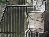
Anyone know what this weird thing in Florida is? It's huge anyway (zoom in all the way), and seems to involve a lot of water... Possibly some sort of power plant maybe?
Thanks: Magnus Schmidt
About the author
Alex has decided that his title will be Senior Vice President of Stuff.

How about this?
http://www.fpl.com/about/plant/contents/turkey_point.shtml
looks pretty close to me
Not sure, but a Google search on “SW 344th St., Miami, Florida”, the nearest named road to this place, reveals many references to an alligator farm… Possibility?
and looks to be in the same area as ou tell from this map of their plant locations
Scratch that. What Fox said. That’s what it is, alright.
lol ok, I’m pretty much certain that its the Turkey Point Plant that I posted earlier.
compare the pictures: View Placemark
http://www.fpl.com/about/plant/images/turkey_point-3.jpg
There’s this too, from a different page on the FPL site ( http://www.fpl.com/about/nuclear/contents/about_turkey_point.shtml ):
“The endangered American crocodile enjoys a favorable habitat in the plant cooling canal system.”
So maybe that’s it – they have to have this large canal system for the water since it’s sort of in the middle of an environmentally sensitive area?
http://sofia.usgs.gov/publications/reports/rali/images/126canalsx.jpg
cooling canals for the power plant linked to by fox
http://sofia.usgs.gov/publications/reports/rali/coastpower.html
better link
hmm – didn’t think that last post of mine went through – it was being slow so I just closed the window and it took awhile to show up on here. o well….
Yes, this is Turkey Point power plant: http://www.fpl.com/about/nuclear/contents/about_turkey_point.shtml
I have found some hi-res images here: http://mfproducts.nos.noaa.gov/images/Photos/5WGS3233.gif http://mfproducts.nos.noaa.gov/images/Photos/5WGS3235.gif
Not all nuclear plants have the big hourglass-shaped cooling towers – this looks to be one that uses a pond system. The plant proper is at the north end of the system – it looks like there are two nuke containment buildings, plus a conventional power plant.
Yeah, the facility in the northeast corner is almost certainly a power plant of some sort. Note the substation on the northwest side with power lines heading north-northwest to a small substation outside Palmetto Bay.
The picture from the first link matches up with the complex at the NE corner of the pond:
http://www.fpl.com/about/plant/images/turkey_point-3.jpg
Eric’s pictures has some interesting features to it. If you look at the two cylinders on the farthest right notice the buildings that seem to be photoshoped in. There seem to be two corresponding parking lots where those buildings are supposed to be.
yea, looks like that is photoshopped. but I think thats what they plan to put there because they are still building it. OR this a more recent picture and the buildings just look funny.
Similar in appearance is the St.Lucie FPL station
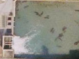
For comparison with an actual alligator farm, here’s Gatorland in Orlando: View Placemark
Its a nuke.
So does anybody know where the gator farm in Miami is that’s referenced in the search I did? Should be near hear somewhere. Unless “That Guy” is right and the gators actually live at the power plant…
That image is the Turkey Point nuclear power plant, in far SE Miami-Dade County, FL. Instead of the more familiar cooling towers that most people associate with nuclear power plants (a la 3 Mile Island), the Turkey Point plant uses a long canal system to dissipate the heat from the water used in the reactor (don’t worry, it’s not radioactive). The year-round warm temperature of the canal water, and the piled-up dredging on the banks (from when the canals were dug) are a perfect, sheltered habitat for the endangered American Crocodile (yes, crocodile…NOT alligator). The crocs live in the canals, and dig their nests in the mounds of dredging on the shores.
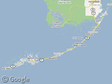
One more thing…the crocodiles don’t only live in the Turkey Point cooling canals. They can be found in the waters off of Miami-Dade County, the northern Florida Keys, and Florida bay in Everglades National Park.
They are very rare, and very endangered (unlike the American Alligator, which has made quite a comeback), but every once in a while you see one on the news that has made its way up to Miami Beach, or in someone’s backyard.
I submitted Turkey Point shortly after I saw the mega nuclear post which didn’t include it. Was my submission just lost in your image triage process? 🙁
I also submitted St Lucie (the other Florida plant) and my local plant, Shearon Harris:
Google image:
View Placemark
More info:
http://en.wikipedia.org/wiki/Shearon_Harris_nuclear_power_plant
More pictures:
http://www.nukeworker.com/pictures/thumbnails101.html
I’m less than 10 miles from the Harris plant, within the evacuation zone, so I’m constantly reminded of its presence by the evacuation signs along the roadside.
Oops, munged the wikipedia URL:
http://en.wikipedia.org/wiki/Shearon_Harris
j.
Jay, I just happened across this submission, and there were far too many ‘power plant’ submissions to cross reference this against them all 🙂
it is a croco doko! you know it! say it!
so its a power plant?!?!?!?!?
Yup, that’s Turkey Point Nuclear Power plant. I’ve been there, and that’s what was there. There are manitties in the cooling canals. They seem to love the slightly warmer than normal water.
It is funny that it does not have the normal cooling towers. People see those and think nukes. There is a coal fired powerplant near my house that has them, and every now and then they get people outside picketing: “No Nukes” etc. They even had a camera crew come down and demand to know why there isn’t more security for the spent fuel.
It’s a giant piano under construction
>For comparison with an actual alligator farm, here’s Gatorland in Orlando: View Placemark
I visited there when I was 8 – long time ago – and had a blast. It’s well worth the visit. At least for an 8-year-old boy. 🙂
Otter
Turkey Point has two coal fired units as well as the two nuclear units.
there is no coal fired units at turkey point the power station consist of 2 oil/gas units rated at 800 mw/2 nuc units rated at 1400 mw/and 1 combined cycle units meaning 4 gas turbines on 1 steam turbine rated at 1200mw
Turkey Point, My stepfather was assistant plant supervisor there. I got to try the simulator there once. I think the control rods were in within 5 min, lol.
Yes this is a power plant. The water ponds you see are for cooling the water before returning to natural source. One of the byproducts of most power generating systems is waste heat. This tells me that enviromental issues such as nearby fishing or perhaps shellfish that would be impacted by hot water runoff. Think of the ponds as and open air radiator system.
Is there a road or trail off of Card Sound Road that leads out to the southern end of Turkey Point ? Is it public land and is fishing allowed on south side of the lower canal leading to Biscayne Bay ? Practice catch and release !